Fallingbrook elevation
Fallingbrook (Prince Edward Island), Canada elevation is 78 meters and Fallingbrook elevation in feet is 256 ft above sea level [src 1]. Fallingbrook is a populated place (feature code) with elevation that is 180 meters (591 ft) smaller than average city elevation in Canada.
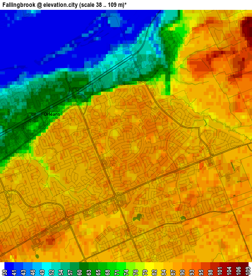
Below is the Elevation map of Fallingbrook, which displays elevation range with different colors. Scale of the first map is from 38 to 109 m (125 to 358 ft) with average elevation of 77.1 meters (=253 ft) [note 1]
These maps also provides idea of topography and contour of this city, they are displayed at different zoom levels. More info about maps, scale and edge coordinates you can find below images.

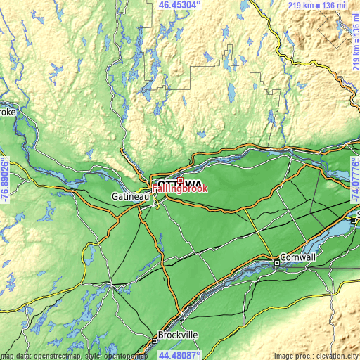
| \ | Map #1 | Map #2 | Topo.Map |
| Scale [m] | 38..109 m | 37..124 m | × |
| Scale [ft] | 125..358 ft | 121..407 ft | × |
| Average | 77.1 m = 253 ft | 72.2 m = 237 ft | × |
| Width | 6.85 km = 4.3 mi | 13.71 km = 8.5 mi | 219.3 km = 136.3 mi |
| Height | 6.85 km = 4.3 mi | 13.71 km = 8.5 mi | 219.3 km = 136.3 mi |
| ↑Max Latitude | 45.506387° | 45.537176° | 46.45304° |
| Latitude at center | 45.47558° | 45.47558° | 45.47558° |
| ↓Min Latitude | 45.444757° | 45.413916° | 44.48087° |
| ← Min Longitude | -75.527955° | -75.571901° | -76.89026° |
| Longitude center | -75.48401° | -75.48401° | -75.48401° |
| →Max Longitude | -75.440065° | -75.396119° | -74.07776° |
Nearby cities:
Cities around Fallingbrook sort by population:
• Ottawa elevation 71 m
18.2 km,  246°
246°
• Gatineau 53 m
17 km,  270°
270°
• Nepean 102 m
24.2 km,  235°
235°
• Clarence-Rockland 55 m
17.2 km,  61°
61°
• Vanier 57 m
14.7 km, 254°
• Buckingham 124 m
13.2 km,  21°
21°
• le Plateau 89 m
23.5 km,  258°
258°
• Queenswood Heights 86 m
1.8 km, 252°
• Val-des-Monts 141 m
24 km,  323°
323°
• Thurso 55 m
22.9 km,  52°
52°
• Limoges 68 m
24.2 km,  130°
130°
• Saint-Alexandre 74 m
20.9 km,  277°
277°
Multilingual:
 En español:
Fallingbrook elevación 78 m.
 En France:
Fallingbrook élévation 78 m.
 Auf Deutsch:
Fallingbrook höhe über dem Meeresspiegel ist 78 m.

Sources and notes:
- [note 1] Map square and city borders are not equal. Map elevation data is calculated only from area inside that square.
- [src 1] Elevation data from geonames database provided with same terms of usage.
- [src 2] The elevation map of Fallingbrook is generated using elevation data from NASA's 3 arcsec (90m) resolution SRTM data.
- [src 3] Base (background) map © OpenStreetMap contributors tiles are generated by Geofabrik and OpenTopoMap.
Copyright & License:
This Fallingbrook Elevation Map is licensed under CC BY-SA. You may reuse any part from this page, if you give a proper credit by linking to this URL:
 More info on terms of use page.