Winchester elevation
Winchester (Ontario, United Counties of Stormont, Dundas and Glengarry), Canada elevation is 75 meters and Winchester elevation in feet is 246 ft above sea level [src 1]. Winchester is a populated place (feature code) with elevation that is 183 meters (600 ft) smaller than average city elevation in Canada.
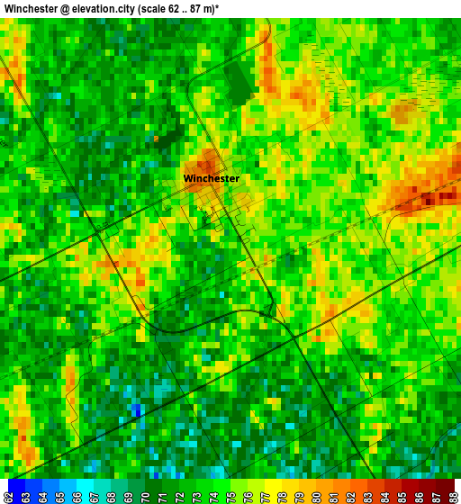
Below is the Elevation map of Winchester, which displays elevation range with different colors. Scale of the first map is from 62 to 87 m (203 to 285 ft) with average elevation of 73.4 meters (=241 ft) [note 1]
These maps also provides idea of topography and contour of this city, they are displayed at different zoom levels. More info about maps, scale and edge coordinates you can find below images.
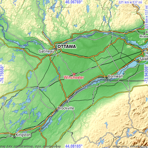
| \ | Map #1 | Topo.Map |
| Scale [m] | 62..87 m | × |
| Scale [ft] | 203..285 ft | × |
| Average | 73.4 m = 241 ft | × |
| Width | 6.9 km = 4.3 mi | 220.8 km = 137.2 mi |
| Height | 6.9 km = 4.3 mi | 220.8 km = 137.2 mi |
| ↑Max Latitude | 45.11442° | 46.06769° |
| Latitude at center | 45.0834° | 45.0834° |
| ↓Min Latitude | 45.052363° | 44.08185° |
| ← Min Longitude | -75.393275° | -76.75558° |
| Longitude center | -75.34933° | -75.34933° |
| →Max Longitude | -75.305385° | -73.94308° |
Nearby cities:
Cities around Winchester sort by population:
• Nepean elevation 102 m
42.8 km,  314°
314°
• Fallingbrook 78 m
44.9 km,  346°
346°
• Queenswood Heights 86 m
44.8 km,  344°
344°
• Prescott 90 m
42.8 km,  197°
197°
• Russell 72 m
18.6 km,  355°
355°
• Richmond 90 m
39.5 km,  286°
286°
• Casselman 64 m
33.3 km,  38°
38°
• Morrisburg 77 m
24.2 km,  147°
147°
• Osgoode 102 m
20.8 km, 290°
• Limoges 68 m
28.9 km,  15°
15°
• Metcalfe 89 m
19 km,  331°
331°
• Bourget 61 m
41.9 km, 21°
Multilingual:
 En español:
Winchester elevación 75 m.
 En France:
Winchester élévation 75 m.
 Auf Deutsch:
Winchester höhe über dem Meeresspiegel ist 75 m.

Sources and notes:
- [note 1] Map square and city borders are not equal. Map elevation data is calculated only from area inside that square.
- [src 1] Elevation data from geonames database provided with same terms of usage.
- [src 2] The elevation map of Winchester is generated using elevation data from NASA's 3 arcsec (90m) resolution SRTM data.
- [src 3] Base (background) map © OpenStreetMap contributors tiles are generated by Geofabrik and OpenTopoMap.
Copyright & License:
This Winchester Elevation Map is licensed under CC BY-SA. You may reuse any part from this page, if you give a proper credit by linking to this URL:
 More info on terms of use page.