Gananoque elevation
Gananoque (Ontario), Canada elevation is 84 meters and Gananoque elevation in feet is 276 ft above sea level [src 1]. Gananoque is a populated place (feature code) with elevation that is 174 meters (571 ft) smaller than average city elevation in Canada.
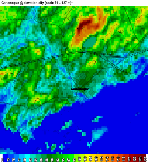
Below is the Elevation map of Gananoque, which displays elevation range with different colors. Scale of the first map is from 71 to 127 m (233 to 417 ft) with average elevation of 84.6 meters (=278 ft) [note 1]
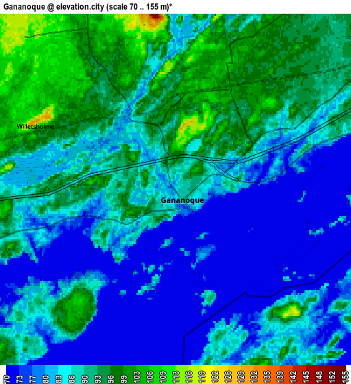
These maps also provides idea of topography and contour of this city, they are displayed at different zoom levels. More info about maps, scale and edge coordinates you can find below images.
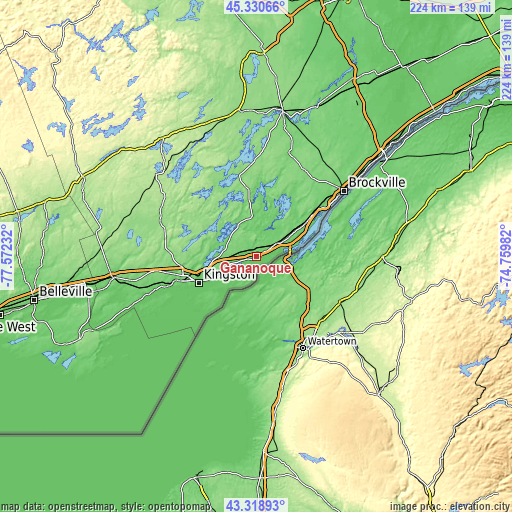
| \ | Map #1 | Map #2 | Topo.Map |
| Scale [m] | 71..127 m | 70..155 m | × |
| Scale [ft] | 233..417 ft | 230..509 ft | × |
| Average | 84.6 m = 278 ft | 86.9 m = 285 ft | × |
| Width | 6.99 km = 4.3 mi | 13.98 km = 8.7 mi | 223.7 km = 139 mi |
| Height | 6.99 km = 4.3 mi | 13.98 km = 8.7 mi | 223.7 km = 139 mi |
| ↑Max Latitude | 44.364845° | 44.396253° | 45.33066° |
| Latitude at center | 44.33342° | 44.33342° | 44.33342° |
| ↓Min Latitude | 44.301978° | 44.270519° | 43.31893° |
| ← Min Longitude | -76.210015° | -76.253961° | -77.57232° |
| Longitude center | -76.16607° | -76.16607° | -76.16607° |
| →Max Longitude | -76.122125° | -76.078179° | -74.75982° |
Nearby cities:
Cities around Gananoque sort by population:
• Kingston elevation 83 m
27.6 km,  245°
245°
• Brockville 93 m
47.6 km,  52°
52°
• Greater Napanee 92 m
63 km,  261°
261°
• Smiths Falls 131 m
64.5 km,  10°
10°
• Napanee 92 m
63 km, 261°
• Perth 134 m
63.4 km,  354°
354°
• Prescott 90 m
66.9 km, 50°
• Picton 149 m
85.5 km,  244°
244°
• Deseronto 96 m
71.9 km, 258°
• Napanee Downtown 92 m
63.2 km, 261°
• Skatepark 93 m
62.6 km, 261°
• Bath 79 m
51.9 km, 251°
Multilingual:
 En español:
Gananoque elevación 84 m.
 En France:
Gananoque élévation 84 m.
 Auf Deutsch:
Gananoque höhe über dem Meeresspiegel ist 84 m.

Sources and notes:
- [note 1] Map square and city borders are not equal. Map elevation data is calculated only from area inside that square.
- [src 1] Elevation data from geonames database provided with same terms of usage.
- [src 2] The elevation map of Gananoque is generated using elevation data from NASA's 3 arcsec (90m) resolution SRTM data.
- [src 3] Base (background) map © OpenStreetMap contributors tiles are generated by Geofabrik and OpenTopoMap.
Copyright & License:
This Gananoque Elevation Map is licensed under CC BY-SA. You may reuse any part from this page, if you give a proper credit by linking to this URL:
 More info on terms of use page.