Picton elevation
Picton (Ontario), Canada elevation is 149 meters and Picton elevation in feet is 489 ft above sea level [src 1]. Picton is a populated place (feature code) with elevation that is 109 meters (358 ft) smaller than average city elevation in Canada.
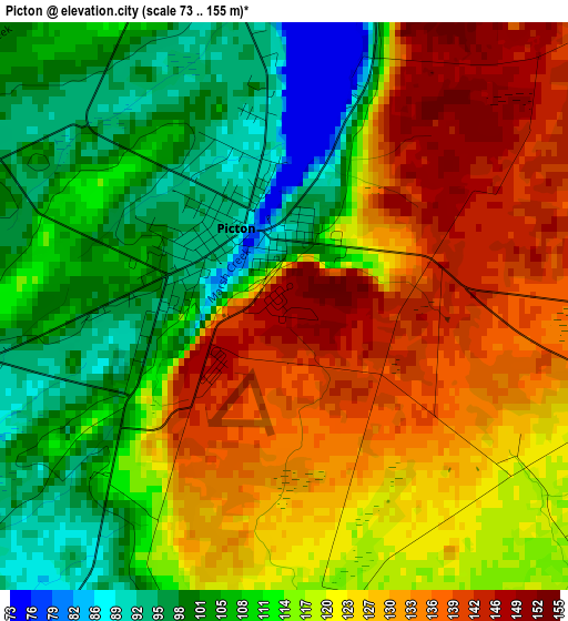
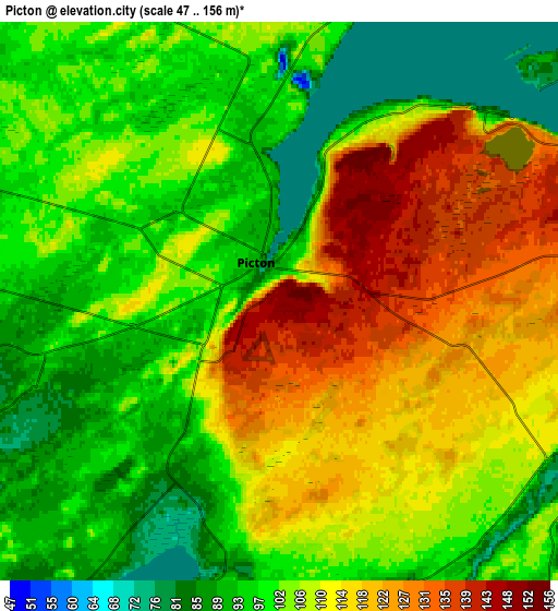
Below is the Elevation map of Picton, which displays elevation range with different colors. Scale of the first map is from 73 to 155 m (240 to 509 ft) with average elevation of 117.9 meters (=387 ft) [note 1]
These maps also provides idea of topography and contour of this city, they are displayed at different zoom levels. More info about maps, scale and edge coordinates you can find below images.
| \ | Map #1 | Map #2 | Topo.Map |
| Scale [m] | 73..155 m | 47..156 m | × |
| Scale [ft] | 240..509 ft | 154..512 ft | × |
| Average | 117.9 m = 387 ft | 105.7 m = 347 ft | × |
| Width | 7.03 km = 4.4 mi | 14.06 km = 8.7 mi | 225 km = 139.8 mi |
| Height | 7.03 km = 4.4 mi | 14.06 km = 8.7 mi | 224.9 km = 139.7 mi |
| ↑Max Latitude | 44.031723° | 44.063309° | 45.00306° |
| Latitude at center | 44.00012° | 44.00012° | 44.00012° |
| ↓Min Latitude | 43.9685° | 43.936863° | 42.97993° |
| ← Min Longitude | -77.176695° | -77.220641° | -78.539° |
| Longitude center | -77.13275° | -77.13275° | -77.13275° |
| →Max Longitude | -77.088805° | -77.044859° | -75.7265° |
Nearby cities:
Cities around Picton sort by population:
• Kingston elevation 83 m
58 km,  63°
63°
• Belleville 93 m
27.2 km,  312°
312°
• Quinte West 130 m
40.2 km,  300°
300°
• Prince Edward 97 m
9.3 km,  270°
270°
• Greater Napanee 92 m
31.4 km,  27°
27°
• Napanee 92 m
31.4 km, 27°
• Stirling 125 m
47.1 km,  315°
315°
• Deseronto 96 m
23.2 km,  16°
16°
• Tweed 157 m
54.8 km,  344°
344°
• Skatepark 93 m
31.7 km, 28°
• Napanee Downtown 92 m
31.2 km, 27°
• Bath 79 m
34.6 km,  53°
53°
Multilingual:
 En español:
Picton elevación 149 m.
 En France:
Picton élévation 149 m.


Sources and notes:
- [note 1] Map square and city borders are not equal. Map elevation data is calculated only from area inside that square.
- [src 1] Elevation data from geonames database provided with same terms of usage.
- [src 2] The elevation map of Picton is generated using elevation data from NASA's 3 arcsec (90m) resolution SRTM data.
- [src 3] Base (background) map © OpenStreetMap contributors tiles are generated by Geofabrik and OpenTopoMap.
Copyright & License:
This Picton Elevation Map is licensed under CC BY-SA. You may reuse any part from this page, if you give a proper credit by linking to this URL:
 More info on terms of use page.