Caçu elevation
Caçu (Goiás), Brazil elevation is 482 meters and Caçu elevation in feet is 1581 ft above sea level [src 1]. Caçu is a populated place (feature code) with elevation that is 100 meters (328 ft) bigger than average city elevation in Brazil.
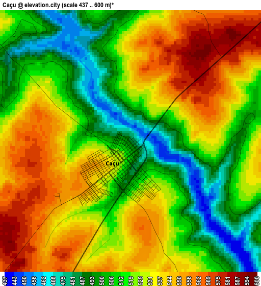
Below is the Elevation map of Caçu, which displays elevation range with different colors. Scale of the first map is from 437 to 600 m (1434 to 1969 ft) with average elevation of 524.8 meters (=1722 ft) [note 1]
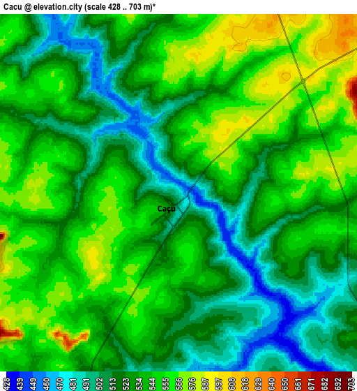
These maps also provides idea of topography and contour of this city, they are displayed at different zoom levels. More info about maps, scale and edge coordinates you can find below images.
| \ | Map #1 | Map #2 | Topo.Map |
| Scale [m] | 437..600 m | 428..703 m | × |
| Scale [ft] | 1434..1969 ft | 1404..2306 ft | × |
| Average | 524.8 m = 1722 ft | 534.1 m = 1752 ft | × |
| Width | 9.26 km = 5.8 mi | 18.53 km = 11.5 mi | 296.4 km = 184.2 mi |
| Height | 9.26 km = 5.8 mi | 18.53 km = 11.5 mi | 296.5 km = 184.2 mi |
| ↑Max Latitude | -18.515004° | -18.473329° | -17.21843° |
| Latitude at center | -18.55667° | -18.55667° | -18.55667° |
| ↓Min Latitude | -18.598325° | -18.639971° | -19.8845° |
| ← Min Longitude | -51.174775° | -51.218721° | -52.53708° |
| Longitude center | -51.13083° | -51.13083° | -51.13083° |
| →Max Longitude | -51.086885° | -51.042939° | -49.72458° |
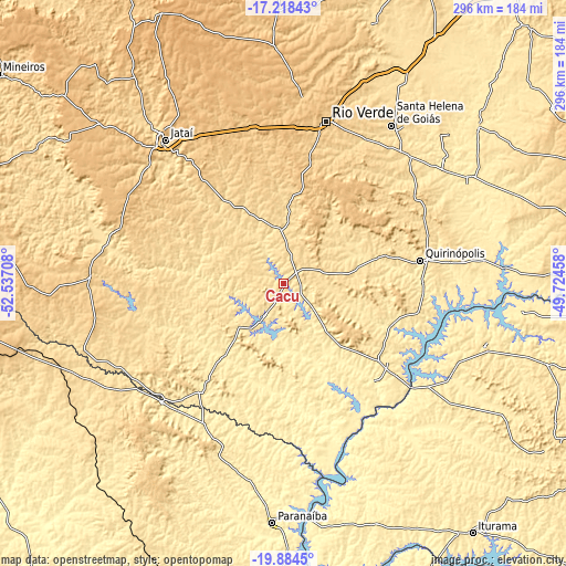
Nearby cities:
Cities around Caçu sort by population:
• Rio Verde elevation 721 m
87 km,  14°
14°
• Ituiutaba 571 m
181.7 km,  104°
104°
• Jataí 741 m
97.8 km,  320°
320°
• Santa Helena de Goiás 566 m
100 km,  34°
34°
• Paranaíba 383 m
124.8 km,  182°
182°
• Quirinópolis 531 m
72.6 km,  80°
80°
• Iturama 469 m
163.1 km,  142°
142°
• Santa Fé do Sul 402 m
185.2 km,  173°
173°
• Cassilândia 475 m
88.7 km,  225°
225°
• Aparecida do Taboado 379 m
170.2 km, 178°
• Capinópolis 536 m
165.1 km,  94°
94°
• Santa Vitória 474 m
110.8 km,  106°
106°
Multilingual:
 En español:
Caçu elevación 482 m.
 En France:
Caçu élévation 482 m.


Sources and notes:
- [note 1] Map square and city borders are not equal. Map elevation data is calculated only from area inside that square.
- [src 1] Elevation data from geonames database provided with same terms of usage.
- [src 2] The elevation map of Caçu is generated using elevation data from NASA's 3 arcsec (90m) resolution SRTM data.
- [src 3] Base (background) map © OpenStreetMap contributors tiles are generated by Geofabrik and OpenTopoMap.
Copyright & License:
This Caçu Elevation Map is licensed under CC BY-SA. You may reuse any part from this page, if you give a proper credit by linking to this URL:
 More info on terms of use page.