Erechim elevation
Erechim (Rio Grande do Sul), Brazil elevation is 790 meters and Erechim elevation in feet is 2592 ft above sea level [src 1]. Erechim is a populated place (feature code) with elevation that is 408 meters (1339 ft) bigger than average city elevation in Brazil.
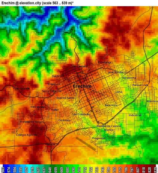
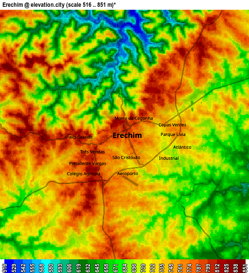
Below is the Elevation map of Erechim, which displays elevation range with different colors. Scale of the first map is from 563 to 839 m (1847 to 2753 ft) with average elevation of 737.5 meters (=2420 ft) [note 1]
These maps also provides idea of topography and contour of this city, they are displayed at different zoom levels. More info about maps, scale and edge coordinates you can find below images.
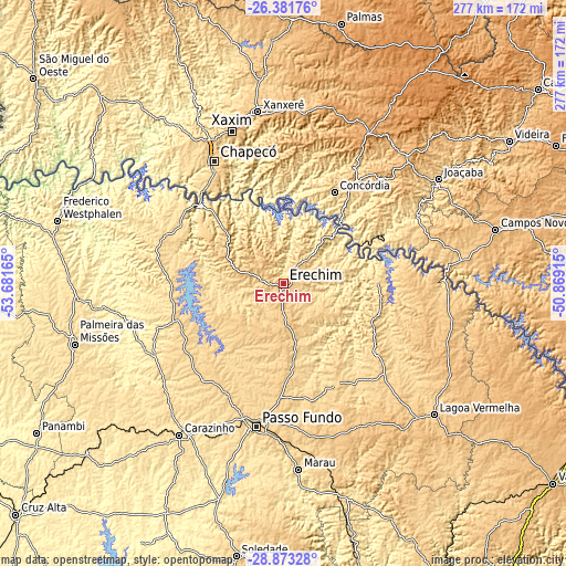
| \ | Map #1 | Map #2 | Topo.Map |
| Scale [m] | 563..839 m | 516..851 m | × |
| Scale [ft] | 1847..2753 ft | 1693..2792 ft | × |
| Average | 737.5 m = 2420 ft | 715.6 m = 2348 ft | × |
| Width | 8.66 km = 5.4 mi | 17.32 km = 10.8 mi | 277 km = 172.1 mi |
| Height | 8.66 km = 5.4 mi | 17.32 km = 10.8 mi | 277 km = 172.1 mi |
| ↑Max Latitude | -27.595671° | -27.556718° | -26.38176° |
| Latitude at center | -27.63461° | -27.63461° | -27.63461° |
| ↓Min Latitude | -27.673535° | -27.712447° | -28.87328° |
| ← Min Longitude | -52.319345° | -52.363291° | -53.68165° |
| Longitude center | -52.2754° | -52.2754° | -52.2754° |
| →Max Longitude | -52.231455° | -52.187509° | -50.86915° |
Nearby cities:
Cities around Erechim sort by population:
• Passo Fundo elevation 689 m
71 km,  190°
190°
• Chapecó 668 m
68.8 km,  330°
330°
• Carazinho 605 m
87.9 km,  214°
214°
• Concórdia 592 m
50.8 km,  28°
28°
• Xanxerê 796 m
85.2 km,  351°
351°
• Marau 553 m
90.9 km,  175°
175°
• Capinzal 459 m
73 km,  63°
63°
• Joaçaba 551 m
91.5 km, 56°
• Celso Ramos 753 m
92.5 km,  89°
89°
• Sarandi 505 m
72.4 km,  241°
241°
• Tapejara 666 m
54.6 km,  151°
151°
• Sananduva 655 m
57.9 km,  127°
127°
Multilingual:
 En español:
Erechim elevación 790 m.
 En France:
Erechim élévation 790 m.


Sources and notes:
- [note 1] Map square and city borders are not equal. Map elevation data is calculated only from area inside that square.
- [src 1] Elevation data from geonames database provided with same terms of usage.
- [src 2] The elevation map of Erechim is generated using elevation data from NASA's 3 arcsec (90m) resolution SRTM data.
- [src 3] Base (background) map © OpenStreetMap contributors tiles are generated by Geofabrik and OpenTopoMap.
Copyright & License:
This Erechim Elevation Map is licensed under CC BY-SA. You may reuse any part from this page, if you give a proper credit by linking to this URL:
 More info on terms of use page.