Chapecó elevation
Chapecó (Santa Catarina), Brazil elevation is 668 meters and Chapecó elevation in feet is 2192 ft above sea level [src 1]. Chapecó is a populated place (feature code) with elevation that is 286 meters (938 ft) bigger than average city elevation in Brazil.
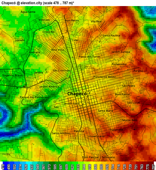
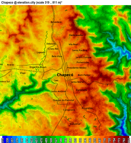
Below is the Elevation map of Chapecó, which displays elevation range with different colors. Scale of the first map is from 478 to 787 m (1568 to 2582 ft) with average elevation of 666.9 meters (=2188 ft) [note 1]
These maps also provides idea of topography and contour of this city, they are displayed at different zoom levels. More info about maps, scale and edge coordinates you can find below images.
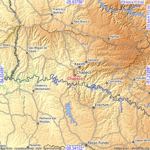
| \ | Map #1 | Map #2 | Topo.Map |
| Scale [m] | 478..787 m | 319..811 m | × |
| Scale [ft] | 1568..2582 ft | 1047..2661 ft | × |
| Average | 666.9 m = 2188 ft | 630.2 m = 2068 ft | × |
| Width | 8.7 km = 5.4 mi | 17.4 km = 10.8 mi | 278.4 km = 173 mi |
| Height | 8.7 km = 5.4 mi | 17.4 km = 10.8 mi | 278.4 km = 173 mi |
| ↑Max Latitude | -27.057261° | -27.018119° | -25.83756° |
| Latitude at center | -27.09639° | -27.09639° | -27.09639° |
| ↓Min Latitude | -27.135505° | -27.174607° | -28.34122° |
| ← Min Longitude | -52.662275° | -52.706221° | -54.02458° |
| Longitude center | -52.61833° | -52.61833° | -52.61833° |
| →Max Longitude | -52.574385° | -52.530439° | -51.21208° |
Nearby cities:
Cities around Chapecó sort by population:
• Erechim elevation 790 m
68.8 km,  150°
150°
• Pato Branco 769 m
96.6 km,  356°
356°
• Concórdia 592 m
60.4 km,  104°
104°
• Palmas 1075 m
92.3 km,  42°
42°
• Xanxerê 796 m
32.3 km, 41°
• Palmeira das Missões 623 m
112.6 km,  217°
217°
• Capinzal 459 m
103.2 km,  105°
105°
• Joaçaba 551 m
110.6 km,  94°
94°
• Frederico Westphalen 528 m
82.1 km,  249°
249°
• Sarandi 505 m
98.9 km,  197°
197°
• São Lourenço do Oeste 881 m
85.2 km,  344°
344°
• Clevelândia 878 m
79.3 km,  10°
10°
Multilingual:
 En español:
Chapecó elevación 668 m.
 En France:
Chapecó élévation 668 m.


Sources and notes:
- [note 1] Map square and city borders are not equal. Map elevation data is calculated only from area inside that square.
- [src 1] Elevation data from geonames database provided with same terms of usage.
- [src 2] The elevation map of Chapecó is generated using elevation data from NASA's 3 arcsec (90m) resolution SRTM data.
- [src 3] Base (background) map © OpenStreetMap contributors tiles are generated by Geofabrik and OpenTopoMap.
Copyright & License:
This Chapecó Elevation Map is licensed under CC BY-SA. You may reuse any part from this page, if you give a proper credit by linking to this URL:
 More info on terms of use page.