Frederico Westphalen elevation
Frederico Westphalen (Rio Grande do Sul), Brazil elevation is 528 meters and Frederico Westphalen elevation in feet is 1732 ft above sea level [src 1]. Frederico Westphalen is a populated place (feature code) with elevation that is 146 meters (479 ft) bigger than average city elevation in Brazil.
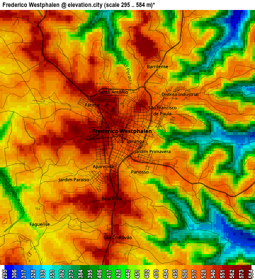
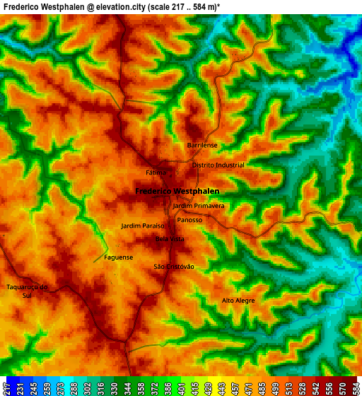
Below is the Elevation map of Frederico Westphalen, which displays elevation range with different colors. Scale of the first map is from 295 to 584 m (968 to 1916 ft) with average elevation of 480.2 meters (=1575 ft) [note 1]
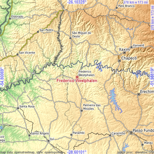
These maps also provides idea of topography and contour of this city, they are displayed at different zoom levels. More info about maps, scale and edge coordinates you can find below images.
| \ | Map #1 | Map #2 | Topo.Map |
| Scale [m] | 295..584 m | 217..584 m | × |
| Scale [ft] | 968..1916 ft | 712..1916 ft | × |
| Average | 480.2 m = 1575 ft | 434.2 m = 1425 ft | × |
| Width | 8.68 km = 5.4 mi | 17.36 km = 10.8 mi | 277.7 km = 172.6 mi |
| Height | 8.68 km = 5.4 mi | 17.36 km = 10.8 mi | 277.7 km = 172.6 mi |
| ↑Max Latitude | -27.320133° | -27.281083° | -26.10325° |
| Latitude at center | -27.35917° | -27.35917° | -27.35917° |
| ↓Min Latitude | -27.398193° | -27.437202° | -28.60101° |
| ← Min Longitude | -53.438385° | -53.482331° | -54.80069° |
| Longitude center | -53.39444° | -53.39444° | -53.39444° |
| →Max Longitude | -53.350495° | -53.306549° | -51.98819° |
Nearby cities:
Cities around Frederico Westphalen sort by population:
• Chapecó elevation 668 m
82.1 km,  69°
69°
• Erechim 790 m
114.5 km,  105°
105°
• Carazinho 605 m
118.9 km,  149°
149°
• Xanxerê 796 m
111.7 km,  61°
61°
• Palmeira das Missões 623 m
60.6 km,  172°
172°
• Panambi 421 m
104.3 km,  185°
185°
• Três de Maio 351 m
95.2 km,  241°
241°
• Três Passos 449 m
54.1 km,  258°
258°
• Sarandi 505 m
79.9 km,  144°
144°
• Horizontina 323 m
94.8 km,  251°
251°
• Giruá 432 m
119.9 km,  231°
231°
• Santo Augusto 533 m
66.4 km,  214°
214°
Multilingual:
 En español:
Frederico Westphalen elevación 528 m.
 En France:
Frederico Westphalen élévation 528 m.
 Auf Deutsch:
Frederico Westphalen höhe über dem Meeresspiegel ist 528 m.
 На русском:
Frederico Westphalen высота над уровнем моря 528 м
Sources and notes:
- [note 1] Map square and city borders are not equal. Map elevation data is calculated only from area inside that square.
- [src 1] Elevation data from geonames database provided with same terms of usage.
- [src 2] The elevation map of Frederico Westphalen is generated using elevation data from NASA's 3 arcsec (90m) resolution SRTM data.
- [src 3] Base (background) map © OpenStreetMap contributors tiles are generated by Geofabrik and OpenTopoMap.
Copyright & License:
This Frederico Westphalen Elevation Map is licensed under CC BY-SA. You may reuse any part from this page, if you give a proper credit by linking to this URL:
 More info on terms of use page.