Tapejara elevation
Tapejara (Rio Grande do Sul), Brazil elevation is 666 meters and Tapejara elevation in feet is 2185 ft above sea level [src 1]. Tapejara is a populated place (feature code) with elevation that is 284 meters (932 ft) bigger than average city elevation in Brazil.
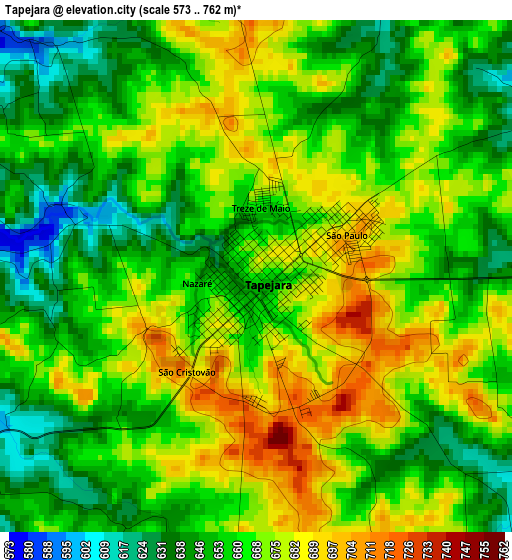
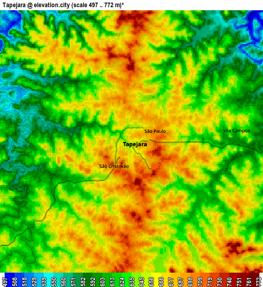
Below is the Elevation map of Tapejara, which displays elevation range with different colors. Scale of the first map is from 573 to 762 m (1880 to 2500 ft) with average elevation of 663.2 meters (=2176 ft) [note 1]
These maps also provides idea of topography and contour of this city, they are displayed at different zoom levels. More info about maps, scale and edge coordinates you can find below images.
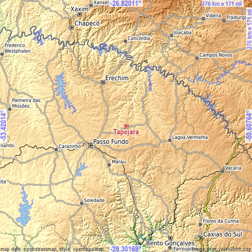
| \ | Map #1 | Map #2 | Topo.Map |
| Scale [m] | 573..762 m | 497..772 m | × |
| Scale [ft] | 1880..2500 ft | 1631..2533 ft | × |
| Average | 663.2 m = 2176 ft | 640.2 m = 2100 ft | × |
| Width | 8.62 km = 5.4 mi | 17.25 km = 10.7 mi | 275.9 km = 171.4 mi |
| Height | 8.62 km = 5.4 mi | 17.25 km = 10.7 mi | 275.9 km = 171.4 mi |
| ↑Max Latitude | -28.029276° | -27.990478° | -26.82011° |
| Latitude at center | -28.06806° | -28.06806° | -28.06806° |
| ↓Min Latitude | -28.10683° | -28.145586° | -29.30169° |
| ← Min Longitude | -52.057835° | -52.101781° | -53.42014° |
| Longitude center | -52.01389° | -52.01389° | -52.01389° |
| →Max Longitude | -51.969945° | -51.925999° | -50.60764° |
Nearby cities:
Cities around Tapejara sort by population:
• Passo Fundo elevation 689 m
44.2 km,  240°
240°
• Erechim 790 m
54.6 km,  331°
331°
• Carazinho 605 m
79.4 km,  252°
252°
• Marau 553 m
46.1 km,  203°
203°
• Lagoa Vermelha 793 m
50.3 km,  108°
108°
• Capinzal 459 m
89.7 km,  26°
26°
• Guaporé 482 m
87.3 km,  172°
172°
• Nova Prata 658 m
88.9 km,  153°
153°
• Celso Ramos 753 m
82.2 km,  54°
54°
• Sarandi 505 m
90.3 km,  278°
278°
• Não Me Toque 524 m
90.2 km, 241°
• Sananduva 655 m
24.2 km,  57°
57°
Multilingual:
 En español:
Tapejara elevación 666 m.
 En France:
Tapejara élévation 666 m.
 Auf Deutsch:
Tapejara höhe über dem Meeresspiegel ist 666 m.

Sources and notes:
- [note 1] Map square and city borders are not equal. Map elevation data is calculated only from area inside that square.
- [src 1] Elevation data from geonames database provided with same terms of usage.
- [src 2] The elevation map of Tapejara is generated using elevation data from NASA's 3 arcsec (90m) resolution SRTM data.
- [src 3] Base (background) map © OpenStreetMap contributors tiles are generated by Geofabrik and OpenTopoMap.
Copyright & License:
This Tapejara Elevation Map is licensed under CC BY-SA. You may reuse any part from this page, if you give a proper credit by linking to this URL:
 More info on terms of use page.