Sananduva elevation
Sananduva (Rio Grande do Sul), Brazil elevation is 655 meters and Sananduva elevation in feet is 2149 ft above sea level [src 1]. Sananduva is a populated place (feature code) with elevation that is 273 meters (896 ft) bigger than average city elevation in Brazil.
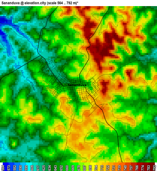
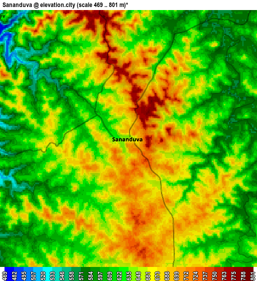
Below is the Elevation map of Sananduva, which displays elevation range with different colors. Scale of the first map is from 564 to 792 m (1850 to 2598 ft) with average elevation of 671.2 meters (=2202 ft) [note 1]
These maps also provides idea of topography and contour of this city, they are displayed at different zoom levels. More info about maps, scale and edge coordinates you can find below images.
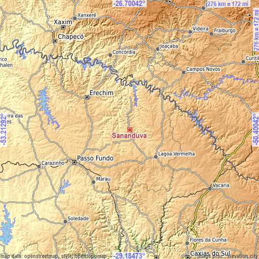
| \ | Map #1 | Map #2 | Topo.Map |
| Scale [m] | 564..792 m | 469..801 m | × |
| Scale [ft] | 1850..2598 ft | 1539..2628 ft | × |
| Average | 671.2 m = 2202 ft | 643.1 m = 2110 ft | × |
| Width | 8.63 km = 5.4 mi | 17.27 km = 10.7 mi | 276.2 km = 171.6 mi |
| Height | 8.63 km = 5.4 mi | 17.27 km = 10.7 mi | 276.2 km = 171.6 mi |
| ↑Max Latitude | -27.910894° | -27.872053° | -26.70042° |
| Latitude at center | -27.94972° | -27.94972° | -27.94972° |
| ↓Min Latitude | -27.988533° | -28.027331° | -29.18473° |
| ← Min Longitude | -51.850615° | -51.894561° | -53.21292° |
| Longitude center | -51.80667° | -51.80667° | -51.80667° |
| →Max Longitude | -51.762725° | -51.718779° | -50.40042° |
Nearby cities:
Cities around Sananduva sort by population:
• Passo Fundo elevation 689 m
68.4 km,  239°
239°
• Erechim 790 m
57.9 km,  307°
307°
• Concórdia 592 m
82.5 km,  344°
344°
• Marau 553 m
67.6 km,  214°
214°
• Lagoa Vermelha 793 m
39.8 km,  136°
136°
• Estrela 910 m
86.1 km,  98°
98°
• Capinzal 459 m
70.1 km,  15°
15°
• Joaçaba 551 m
90.8 km, 19°
• Campos Novos 937 m
83.6 km,  43°
43°
• Nova Prata 658 m
94.7 km,  168°
168°
• Celso Ramos 753 m
58 km,  52°
52°
• Tapejara 666 m
24.2 km, 237°
Multilingual:
 En español:
Sananduva elevación 655 m.
 En France:
Sananduva élévation 655 m.
 Auf Deutsch:
Sananduva höhe über dem Meeresspiegel ist 655 m.

Sources and notes:
- [note 1] Map square and city borders are not equal. Map elevation data is calculated only from area inside that square.
- [src 1] Elevation data from geonames database provided with same terms of usage.
- [src 2] The elevation map of Sananduva is generated using elevation data from NASA's 3 arcsec (90m) resolution SRTM data.
- [src 3] Base (background) map © OpenStreetMap contributors tiles are generated by Geofabrik and OpenTopoMap.
Copyright & License:
This Sananduva Elevation Map is licensed under CC BY-SA. You may reuse any part from this page, if you give a proper credit by linking to this URL:
 More info on terms of use page.