Lagoa Vermelha elevation
Lagoa Vermelha (Rio Grande do Sul), Brazil elevation is 793 meters and Lagoa Vermelha elevation in feet is 2602 ft above sea level [src 1]. Lagoa Vermelha is a populated place (feature code) with elevation that is 411 meters (1348 ft) bigger than average city elevation in Brazil.
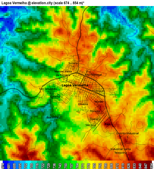
Below is the Elevation map of Lagoa Vermelha, which displays elevation range with different colors. Scale of the first map is from 674 to 854 m (2211 to 2802 ft) with average elevation of 765.9 meters (=2513 ft) [note 1]
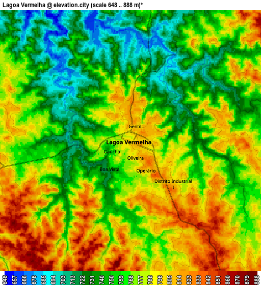
These maps also provides idea of topography and contour of this city, they are displayed at different zoom levels. More info about maps, scale and edge coordinates you can find below images.

| \ | Map #1 | Map #2 | Topo.Map |
| Scale [m] | 674..854 m | 648..888 m | × |
| Scale [ft] | 2211..2802 ft | 2126..2913 ft | × |
| Average | 765.9 m = 2513 ft | 769.2 m = 2524 ft | × |
| Width | 8.61 km = 5.3 mi | 17.22 km = 10.7 mi | 275.6 km = 171.2 mi |
| Height | 8.61 km = 5.3 mi | 17.22 km = 10.7 mi | 275.6 km = 171.2 mi |
| ↑Max Latitude | -28.169877° | -28.13113° | -26.96226° |
| Latitude at center | -28.20861° | -28.20861° | -28.20861° |
| ↓Min Latitude | -28.247329° | -28.286034° | -29.44059° |
| ← Min Longitude | -51.569775° | -51.613721° | -52.93208° |
| Longitude center | -51.52583° | -51.52583° | -51.52583° |
| →Max Longitude | -51.481885° | -51.437939° | -50.11958° |
Nearby cities:
Cities around Lagoa Vermelha sort by population:
• Passo Fundo elevation 689 m
86.5 km,  266°
266°
• Vacaria 970 m
67 km,  120°
120°
• Marau 553 m
71.2 km,  247°
247°
• Estrela 910 m
59.9 km,  74°
74°
• Campos Novos 937 m
94.5 km,  18°
18°
• Guaporé 482 m
79.3 km,  206°
206°
• Veranópolis 669 m
80.9 km,  181°
181°
• São Marcos 741 m
95.8 km,  152°
152°
• Nova Prata 658 m
64.5 km,  187°
187°
• Celso Ramos 753 m
66.5 km, 16°
• Tapejara 666 m
50.3 km,  288°
288°
• Sananduva 655 m
39.8 km,  316°
316°
Multilingual:
 En español:
Lagoa Vermelha elevación 793 m.
 En France:
Lagoa Vermelha élévation 793 m.
 Auf Deutsch:
Lagoa Vermelha höhe über dem Meeresspiegel ist 793 m.

Sources and notes:
- [note 1] Map square and city borders are not equal. Map elevation data is calculated only from area inside that square.
- [src 1] Elevation data from geonames database provided with same terms of usage.
- [src 2] The elevation map of Lagoa Vermelha is generated using elevation data from NASA's 3 arcsec (90m) resolution SRTM data.
- [src 3] Base (background) map © OpenStreetMap contributors tiles are generated by Geofabrik and OpenTopoMap.
Copyright & License:
This Lagoa Vermelha Elevation Map is licensed under CC BY-SA. You may reuse any part from this page, if you give a proper credit by linking to this URL:
 More info on terms of use page.