Ibaté elevation
Ibaté (São Paulo), Brazil elevation is 849 meters and Ibaté elevation in feet is 2785 ft above sea level [src 1]. Ibaté is a populated place (feature code) with elevation that is 467 meters (1532 ft) bigger than average city elevation in Brazil.
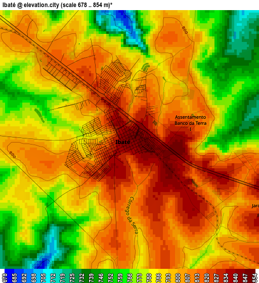
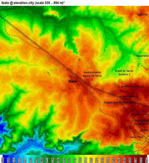
Below is the Elevation map of Ibaté, which displays elevation range with different colors. Scale of the first map is from 678 to 854 m (2224 to 2802 ft) with average elevation of 792.2 meters (=2599 ft) [note 1]
These maps also provides idea of topography and contour of this city, they are displayed at different zoom levels. More info about maps, scale and edge coordinates you can find below images.
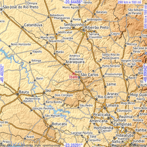
| \ | Map #1 | Map #2 | Topo.Map |
| Scale [m] | 678..854 m | 539..894 m | × |
| Scale [ft] | 2224..2802 ft | 1768..2933 ft | × |
| Average | 792.2 m = 2599 ft | 752.8 m = 2470 ft | × |
| Width | 9.06 km = 5.6 mi | 18.13 km = 11.3 mi | 290 km = 180.2 mi |
| Height | 9.06 km = 5.6 mi | 18.13 km = 11.3 mi | 290 km = 180.2 mi |
| ↑Max Latitude | -21.913956° | -21.87318° | -20.64456° |
| Latitude at center | -21.95472° | -21.95472° | -21.95472° |
| ↓Min Latitude | -21.995473° | -22.036213° | -23.25291° |
| ← Min Longitude | -48.040615° | -48.084561° | -49.40292° |
| Longitude center | -47.99667° | -47.99667° | -47.99667° |
| →Max Longitude | -47.952725° | -47.908779° | -46.59042° |
Nearby cities:
Cities around Ibaté sort by population:
• São Carlos elevation 838 m
13 km,  122°
122°
• Araraquara 677 m
25.7 km,  313°
313°
• Matão 574 m
54.6 km,  315°
315°
• Pirassununga 631 m
59 km,  94°
94°
• Porto Ferreira 564 m
54.6 km,  78°
78°
• Américo Brasiliense 726 m
27.8 km,  337°
337°
• Descalvado 688 m
39.3 km, 81°
• Santa Rita do Passa Quatro 759 m
60 km,  63°
63°
• Brotas 651 m
39 km,  200°
200°
• Itirapina 760 m
37.7 km,  151°
151°
• Ribeirão Bonito 580 m
22.3 km,  236°
236°
• Boa Esperança do Sul 480 m
40.9 km,  264°
264°
Multilingual:
 En español:
Ibaté elevación 849 m.
 En France:
Ibaté élévation 849 m.


Sources and notes:
- [note 1] Map square and city borders are not equal. Map elevation data is calculated only from area inside that square.
- [src 1] Elevation data from geonames database provided with same terms of usage.
- [src 2] The elevation map of Ibaté is generated using elevation data from NASA's 3 arcsec (90m) resolution SRTM data.
- [src 3] Base (background) map © OpenStreetMap contributors tiles are generated by Geofabrik and OpenTopoMap.
Copyright & License:
This Ibaté Elevation Map is licensed under CC BY-SA. You may reuse any part from this page, if you give a proper credit by linking to this URL:
 More info on terms of use page.