Pirassununga elevation
Pirassununga (São Paulo), Brazil elevation is 631 meters and Pirassununga elevation in feet is 2070 ft above sea level [src 1]. Pirassununga is a populated place (feature code) with elevation that is 249 meters (817 ft) bigger than average city elevation in Brazil.
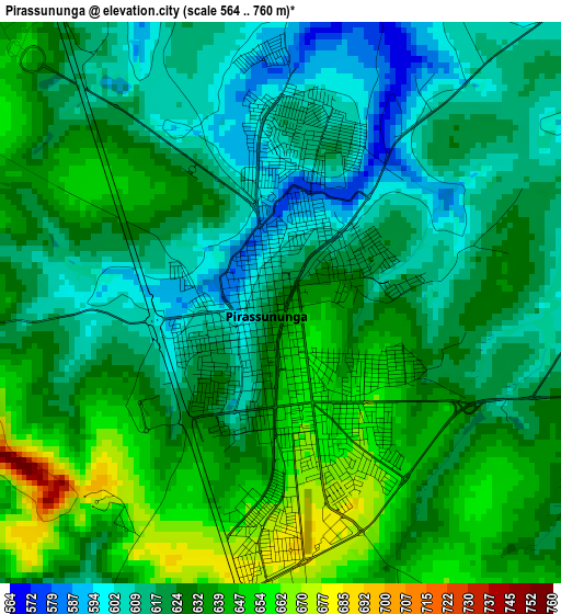
Below is the Elevation map of Pirassununga, which displays elevation range with different colors. Scale of the first map is from 564 to 760 m (1850 to 2493 ft) with average elevation of 626.6 meters (=2056 ft) [note 1]
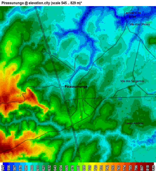
These maps also provides idea of topography and contour of this city, they are displayed at different zoom levels. More info about maps, scale and edge coordinates you can find below images.
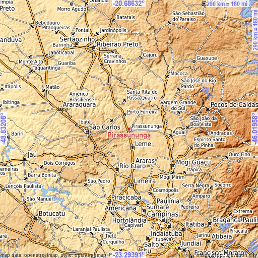
| \ | Map #1 | Map #2 | Topo.Map |
| Scale [m] | 564..760 m | 545..829 m | × |
| Scale [ft] | 1850..2493 ft | 1788..2720 ft | × |
| Average | 626.6 m = 2056 ft | 632.7 m = 2076 ft | × |
| Width | 9.06 km = 5.6 mi | 18.12 km = 11.3 mi | 289.9 km = 180.1 mi |
| Height | 9.06 km = 5.6 mi | 18.12 km = 11.3 mi | 290 km = 180.2 mi |
| ↑Max Latitude | -21.955358° | -21.914594° | -20.68632° |
| Latitude at center | -21.99611° | -21.99611° | -21.99611° |
| ↓Min Latitude | -22.036851° | -22.07758° | -23.29391° |
| ← Min Longitude | -47.469775° | -47.513721° | -48.83208° |
| Longitude center | -47.42583° | -47.42583° | -47.42583° |
| →Max Longitude | -47.381885° | -47.337939° | -46.01958° |
Nearby cities:
Cities around Pirassununga sort by population:
• São Carlos elevation 838 m
48 km,  267°
267°
• Rio Claro 617 m
48.2 km,  196°
196°
• Araras 634 m
40.3 km,  173°
173°
• Leme 630 m
21.4 km, 170°
• Porto Ferreira 564 m
16.7 km,  340°
340°
• Aguaí 665 m
46.6 km,  98°
98°
• Descalvado 688 m
22.4 km,  297°
297°
• Santa Cruz das Palmeiras 655 m
26.2 km,  44°
44°
• Santa Rita do Passa Quatro 759 m
32.2 km,  350°
350°
• Casa Branca 692 m
42.9 km,  54°
54°
• Conchal 594 m
45.4 km,  144°
144°
• Tambaú 703 m
35.9 km,  25°
25°
Multilingual:
 En español:
Pirassununga elevación 631 m.
 En France:
Pirassununga élévation 631 m.
 Auf Deutsch:
Pirassununga höhe über dem Meeresspiegel ist 631 m.

Sources and notes:
- [note 1] Map square and city borders are not equal. Map elevation data is calculated only from area inside that square.
- [src 1] Elevation data from geonames database provided with same terms of usage.
- [src 2] The elevation map of Pirassununga is generated using elevation data from NASA's 3 arcsec (90m) resolution SRTM data.
- [src 3] Base (background) map © OpenStreetMap contributors tiles are generated by Geofabrik and OpenTopoMap.
Copyright & License:
This Pirassununga Elevation Map is licensed under CC BY-SA. You may reuse any part from this page, if you give a proper credit by linking to this URL:
 More info on terms of use page.