Leme elevation
Leme (São Paulo), Brazil elevation is 630 meters and Leme elevation in feet is 2067 ft above sea level [src 1]. Leme is a populated place (feature code) with elevation that is 248 meters (814 ft) bigger than average city elevation in Brazil.
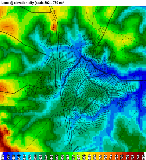
Below is the Elevation map of Leme, which displays elevation range with different colors. Scale of the first map is from 592 to 750 m (1942 to 2461 ft) with average elevation of 642.2 meters (=2107 ft) [note 1]
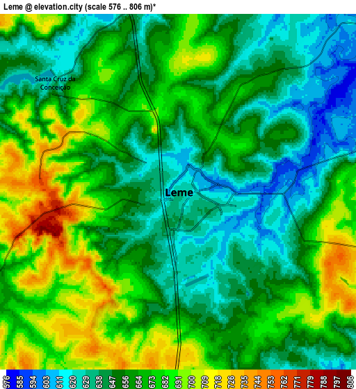
These maps also provides idea of topography and contour of this city, they are displayed at different zoom levels. More info about maps, scale and edge coordinates you can find below images.
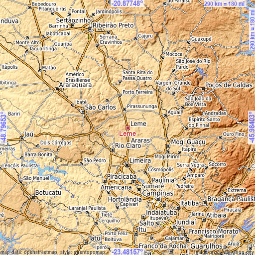
| \ | Map #1 | Map #2 | Topo.Map |
| Scale [m] | 592..750 m | 576..806 m | × |
| Scale [ft] | 1942..2461 ft | 1890..2644 ft | × |
| Average | 642.2 m = 2107 ft | 661.3 m = 2170 ft | × |
| Width | 9.05 km = 5.6 mi | 18.1 km = 11.2 mi | 289.5 km = 179.9 mi |
| Height | 9.05 km = 5.6 mi | 18.1 km = 11.2 mi | 289.6 km = 179.9 mi |
| ↑Max Latitude | -22.144862° | -22.104153° | -20.87748° |
| Latitude at center | -22.18556° | -22.18556° | -22.18556° |
| ↓Min Latitude | -22.226246° | -22.26692° | -23.48157° |
| ← Min Longitude | -47.434225° | -47.478171° | -48.79653° |
| Longitude center | -47.39028° | -47.39028° | -47.39028° |
| →Max Longitude | -47.346335° | -47.302389° | -45.98403° |
Nearby cities:
Cities around Leme sort by population:
• Limeira elevation 582 m
42.2 km,  181°
181°
• Rio Claro 617 m
30.7 km,  215°
215°
• Araras 634 m
19.1 km, 178°
• Pirassununga 631 m
21.4 km,  350°
350°
• Porto Ferreira 564 m
38 km, 346°
• Aguaí 665 m
44.7 km,  71°
71°
• Descalvado 688 m
39.2 km,  322°
322°
• Santa Cruz das Palmeiras 655 m
42.5 km,  20°
20°
• Cordeirópolis 660 m
33.7 km,  191°
191°
• Conchal 594 m
27.6 km,  125°
125°
• Santa Gertrudes 592 m
33.4 km,  205°
205°
• Itirapina 760 m
45.1 km,  260°
260°
Multilingual:
 En español:
Leme elevación 630 m.
 En France:
Leme élévation 630 m.


Sources and notes:
- [note 1] Map square and city borders are not equal. Map elevation data is calculated only from area inside that square.
- [src 1] Elevation data from geonames database provided with same terms of usage.
- [src 2] The elevation map of Leme is generated using elevation data from NASA's 3 arcsec (90m) resolution SRTM data.
- [src 3] Base (background) map © OpenStreetMap contributors tiles are generated by Geofabrik and OpenTopoMap.
Copyright & License:
This Leme Elevation Map is licensed under CC BY-SA. You may reuse any part from this page, if you give a proper credit by linking to this URL:
 More info on terms of use page.