Araraquara elevation
Araraquara (São Paulo), Brazil elevation is 677 meters and Araraquara elevation in feet is 2221 ft above sea level [src 1]. Araraquara is a populated place (feature code) with elevation that is 295 meters (968 ft) bigger than average city elevation in Brazil.
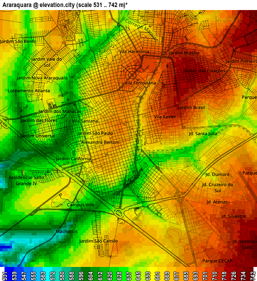
Below is the Elevation map of Araraquara, which displays elevation range with different colors. Scale of the first map is from 531 to 742 m (1742 to 2434 ft) with average elevation of 662.8 meters (=2175 ft) [note 1]
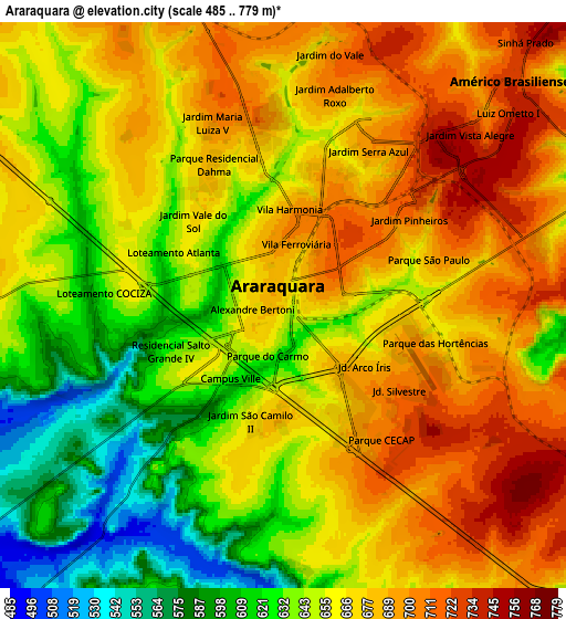
These maps also provides idea of topography and contour of this city, they are displayed at different zoom levels. More info about maps, scale and edge coordinates you can find below images.
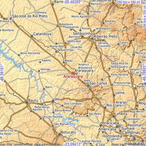
| \ | Map #1 | Map #2 | Topo.Map |
| Scale [m] | 531..742 m | 485..779 m | × |
| Scale [ft] | 1742..2434 ft | 1591..2556 ft | × |
| Average | 662.8 m = 2175 ft | 660.6 m = 2167 ft | × |
| Width | 9.07 km = 5.6 mi | 18.15 km = 11.3 mi | 290.3 km = 180.4 mi |
| Height | 9.07 km = 5.6 mi | 18.15 km = 11.3 mi | 290.4 km = 180.4 mi |
| ↑Max Latitude | -21.75363° | -21.712808° | -20.48285° |
| Latitude at center | -21.79444° | -21.79444° | -21.79444° |
| ↓Min Latitude | -21.835238° | -21.876025° | -23.09413° |
| ← Min Longitude | -48.219505° | -48.263451° | -49.58181° |
| Longitude center | -48.17556° | -48.17556° | -48.17556° |
| →Max Longitude | -48.131615° | -48.087669° | -46.76931° |
Nearby cities:
Cities around Araraquara sort by population:
• São Carlos elevation 838 m
38.4 km,  130°
130°
• Matão 574 m
28.9 km,  317°
317°
• Taquaritinga 573 m
55 km, 321°
• Américo Brasiliense 726 m
10.9 km,  44°
44°
• Guariba 619 m
48.6 km,  353°
353°
• Ibaté 849 m
25.7 km, 133°
• Descalvado 688 m
58.7 km,  101°
101°
• Brotas 651 m
54.7 km,  174°
174°
• Pradópolis 539 m
49.7 km,  13°
13°
• Tabatinga 489 m
53.6 km,  279°
279°
• Ribeirão Bonito 580 m
30.3 km,  180°
180°
• Boa Esperança do Sul 480 m
31.3 km,  225°
225°
Multilingual:
 En español:
Araraquara elevación 677 m.
 En France:
Araraquara élévation 677 m.
 Auf Deutsch:
Araraquara höhe über dem Meeresspiegel ist 677 m.

Sources and notes:
- [note 1] Map square and city borders are not equal. Map elevation data is calculated only from area inside that square.
- [src 1] Elevation data from geonames database provided with same terms of usage.
- [src 2] The elevation map of Araraquara is generated using elevation data from NASA's 3 arcsec (90m) resolution SRTM data.
- [src 3] Base (background) map © OpenStreetMap contributors tiles are generated by Geofabrik and OpenTopoMap.
Copyright & License:
This Araraquara Elevation Map is licensed under CC BY-SA. You may reuse any part from this page, if you give a proper credit by linking to this URL:
 More info on terms of use page.