São Felipe elevation
São Felipe (Bahia, Caraíbas), Brazil elevation is 463 meters and São Felipe elevation in feet is 1519 ft above sea level [src 1]. São Felipe is a populated place (feature code) with elevation that is 81 meters (266 ft) bigger than average city elevation in Brazil.
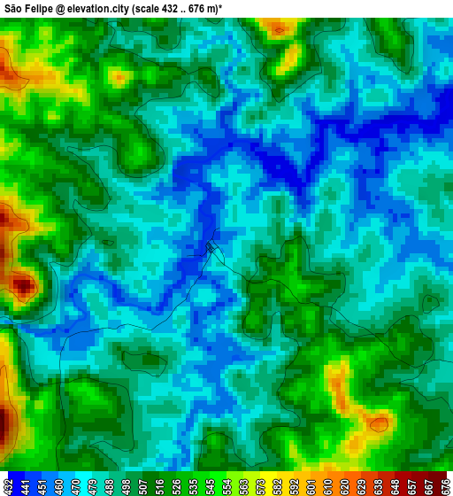
Below is the Elevation map of São Felipe, which displays elevation range with different colors. Scale of the first map is from 432 to 676 m (1417 to 2218 ft) with average elevation of 498.3 meters (=1635 ft) [note 1]
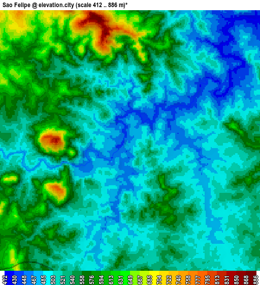
These maps also provides idea of topography and contour of this city, they are displayed at different zoom levels. More info about maps, scale and edge coordinates you can find below images.
| \ | Map #1 | Map #2 | Topo.Map |
| Scale [m] | 432..676 m | 412..886 m | × |
| Scale [ft] | 1417..2218 ft | 1352..2907 ft | × |
| Average | 498.3 m = 1635 ft | 533.8 m = 1751 ft | × |
| Width | 9.45 km = 5.9 mi | 18.89 km = 11.7 mi | 302.3 km = 187.8 mi |
| Height | 9.45 km = 5.9 mi | 18.89 km = 11.7 mi | 302.3 km = 187.8 mi |
| ↑Max Latitude | -14.796116° | -14.753624° | -13.47509° |
| Latitude at center | -14.8386° | -14.8386° | -14.8386° |
| ↓Min Latitude | -14.881076° | -14.923543° | -16.19356° |
| ← Min Longitude | -41.435685° | -41.479631° | -42.79799° |
| Longitude center | -41.39174° | -41.39174° | -41.39174° |
| →Max Longitude | -41.347795° | -41.303849° | -39.98549° |
Nearby cities:
Cities around São Felipe sort by population:
• Vitória da Conquista elevation 876 m
59.4 km,  92°
92°
• Brumado 427 m
76.5 km,  337°
337°
• Itambé 357 m
94 km,  118°
118°
• Águas Vermelhas 735 m
101.3 km,  184°
184°
• Santana 519 m
60.3 km,  313°
313°
• Caculé 584 m
96.8 km,  292°
292°
• São João do Paraíso 789 m
85.2 km,  231°
231°
• Tanhaçu 433 m
92.2 km,  9°
9°
• Ituaçu 527 m
114.5 km, 5°
• Encruzilhada 627 m
92.8 km,  146°
146°
• Anagé 378 m
37.3 km,  47°
47°
• Tremedal 514 m
15.4 km,  187°
187°
Multilingual:
 En español:
São Felipe elevación 463 m.
 En France:
São Felipe élévation 463 m.
 Auf Deutsch:
São Felipe höhe über dem Meeresspiegel ist 463 m.

Sources and notes:
- [note 1] Map square and city borders are not equal. Map elevation data is calculated only from area inside that square.
- [src 1] Elevation data from geonames database provided with same terms of usage.
- [src 2] The elevation map of São Felipe is generated using elevation data from NASA's 3 arcsec (90m) resolution SRTM data.
- [src 3] Base (background) map © OpenStreetMap contributors tiles are generated by Geofabrik and OpenTopoMap.
Copyright & License:
This São Felipe Elevation Map is licensed under CC BY-SA. You may reuse any part from this page, if you give a proper credit by linking to this URL:
 More info on terms of use page.