Águas Vermelhas elevation
Águas Vermelhas (Minas Gerais), Brazil elevation is 735 meters and Águas Vermelhas elevation in feet is 2411 ft above sea level [src 1]. Águas Vermelhas is a populated place (feature code) with elevation that is 353 meters (1158 ft) bigger than average city elevation in Brazil.
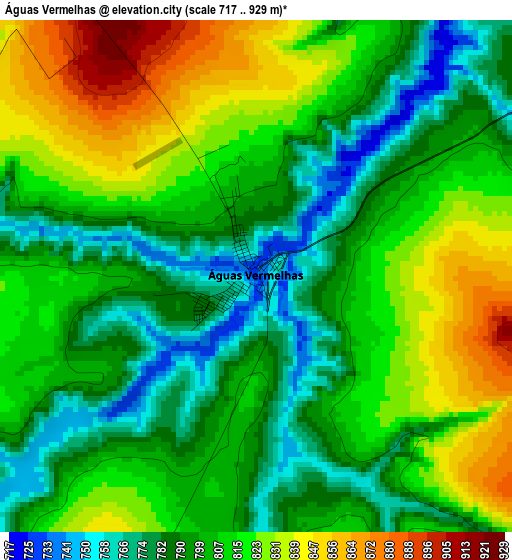
Below is the Elevation map of Águas Vermelhas, which displays elevation range with different colors. Scale of the first map is from 717 to 929 m (2352 to 3048 ft) with average elevation of 806.4 meters (=2646 ft) [note 1]
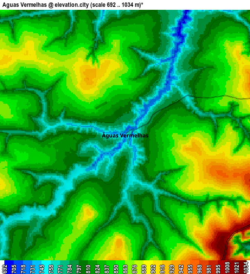
These maps also provides idea of topography and contour of this city, they are displayed at different zoom levels. More info about maps, scale and edge coordinates you can find below images.
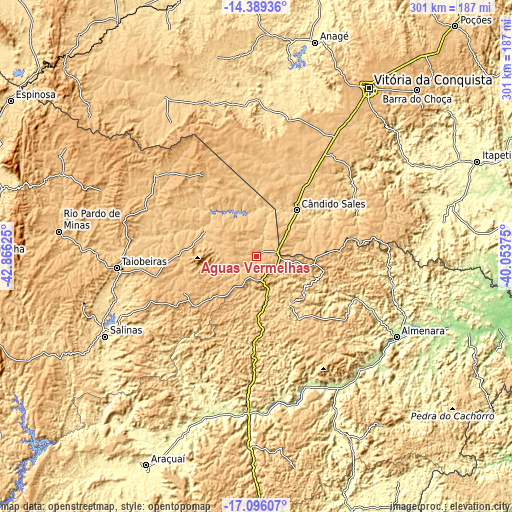
| \ | Map #1 | Map #2 | Topo.Map |
| Scale [m] | 717..929 m | 692..1034 m | × |
| Scale [ft] | 2352..3048 ft | 2270..3392 ft | × |
| Average | 806.4 m = 2646 ft | 832.1 m = 2730 ft | × |
| Width | 9.41 km = 5.8 mi | 18.81 km = 11.7 mi | 301 km = 187 mi |
| Height | 9.41 km = 5.8 mi | 18.81 km = 11.7 mi | 301 km = 187 mi |
| ↑Max Latitude | -15.70492° | -15.66261° | -14.38936° |
| Latitude at center | -15.74722° | -15.74722° | -15.74722° |
| ↓Min Latitude | -15.789512° | -15.831794° | -17.09607° |
| ← Min Longitude | -41.503945° | -41.547891° | -42.86625° |
| Longitude center | -41.46° | -41.46° | -41.46° |
| →Max Longitude | -41.416055° | -41.372109° | -40.05375° |
Nearby cities:
Cities around Águas Vermelhas sort by population:
• Almenara elevation 193 m
95.1 km,  120°
120°
• Salinas 472 m
100.5 km,  242°
242°
• Taiobeiras 832 m
83 km,  265°
265°
• Itambé 357 m
105.5 km,  58°
58°
• Pedra Azul 678 m
33.6 km,  148°
148°
• Jequitinhonha 239 m
90.6 km, 147°
• Medina 572 m
52.9 km,  181°
181°
• São Felipe 463 m
101.3 km,  4°
4°
• São João do Paraíso 789 m
76.5 km,  309°
309°
• Itinga 268 m
101.6 km,  198°
198°
• Encruzilhada 627 m
63.6 km,  67°
67°
• Tremedal 514 m
85.9 km, 3°
Multilingual:
 En español:
Águas Vermelhas elevación 735 m.
 En France:
Águas Vermelhas élévation 735 m.
 Auf Deutsch:
Águas Vermelhas höhe über dem Meeresspiegel ist 735 m.

Sources and notes:
- [note 1] Map square and city borders are not equal. Map elevation data is calculated only from area inside that square.
- [src 1] Elevation data from geonames database provided with same terms of usage.
- [src 2] The elevation map of Águas Vermelhas is generated using elevation data from NASA's 3 arcsec (90m) resolution SRTM data.
- [src 3] Base (background) map © OpenStreetMap contributors tiles are generated by Geofabrik and OpenTopoMap.
Copyright & License:
This Águas Vermelhas Elevation Map is licensed under CC BY-SA. You may reuse any part from this page, if you give a proper credit by linking to this URL:
 More info on terms of use page.