Almenara elevation
Almenara (Minas Gerais), Brazil elevation is 193 meters and Almenara elevation in feet is 633 ft above sea level [src 1]. Almenara is a populated place (feature code) with elevation that is 189 meters (620 ft) smaller than average city elevation in Brazil.
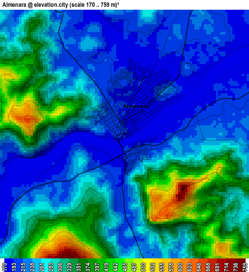
Below is the Elevation map of Almenara, which displays elevation range with different colors. Scale of the first map is from 170 to 759 m (558 to 2490 ft) with average elevation of 281.2 meters (=923 ft) [note 1]
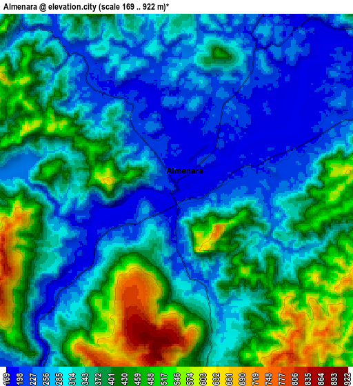
These maps also provides idea of topography and contour of this city, they are displayed at different zoom levels. More info about maps, scale and edge coordinates you can find below images.
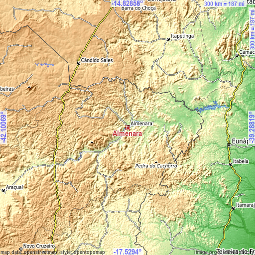
| \ | Map #1 | Map #2 | Topo.Map |
| Scale [m] | 170..759 m | 169..922 m | × |
| Scale [ft] | 558..2490 ft | 554..3025 ft | × |
| Average | 281.2 m = 923 ft | 352.8 m = 1157 ft | × |
| Width | 9.39 km = 5.8 mi | 18.77 km = 11.7 mi | 300.3 km = 186.6 mi |
| Height | 9.39 km = 5.8 mi | 18.77 km = 11.7 mi | 300.3 km = 186.6 mi |
| ↑Max Latitude | -16.141402° | -16.099184° | -14.82858° |
| Latitude at center | -16.18361° | -16.18361° | -16.18361° |
| ↓Min Latitude | -16.225809° | -16.268° | -17.5294° |
| ← Min Longitude | -40.738385° | -40.782331° | -42.10069° |
| Longitude center | -40.69444° | -40.69444° | -40.69444° |
| →Max Longitude | -40.650495° | -40.606549° | -39.28819° |
Nearby cities:
Cities around Almenara sort by population:
• Itapetinga elevation 282 m
114.4 km,  24°
24°
• Itambé 357 m
104.6 km,  4°
4°
• Pedra Azul 678 m
67.4 km,  287°
287°
• Águas Vermelhas 735 m
95.1 km,  300°
300°
• Jequitinhonha 239 m
43.1 km,  229°
229°
• Medina 572 m
83.7 km,  267°
267°
• Itanhém 189 m
116 km,  160°
160°
• Itarantim 255 m
89 km,  49°
49°
• Águas Formosas 260 m
103.2 km,  194°
194°
• Guaratinga 171 m
107.1 km,  114°
114°
• Joaíma 270 m
63.4 km,  214°
214°
• Encruzilhada 627 m
76.1 km,  342°
342°
Multilingual:
 En español:
Almenara elevación 193 m.
 En France:
Almenara élévation 193 m.
 Auf Deutsch:
Almenara höhe über dem Meeresspiegel ist 193 m.
 На русском:
Альменара, Алменара высота над уровнем моря 193 м
Sources and notes:
- [note 1] Map square and city borders are not equal. Map elevation data is calculated only from area inside that square.
- [src 1] Elevation data from geonames database provided with same terms of usage.
- [src 2] The elevation map of Almenara is generated using elevation data from NASA's 3 arcsec (90m) resolution SRTM data.
- [src 3] Base (background) map © OpenStreetMap contributors tiles are generated by Geofabrik and OpenTopoMap.
Copyright & License:
This Almenara Elevation Map is licensed under CC BY-SA. You may reuse any part from this page, if you give a proper credit by linking to this URL:
 More info on terms of use page.