Anagé elevation
Anagé (Bahia), Brazil elevation is 378 meters and Anagé elevation in feet is 1240 ft above sea level [src 1]. Anagé is a populated place (feature code) with elevation that is 4 meters (13 ft) smaller than average city elevation in Brazil.
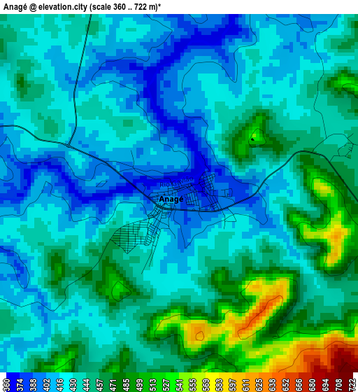
Below is the Elevation map of Anagé, which displays elevation range with different colors. Scale of the first map is from 360 to 722 m (1181 to 2369 ft) with average elevation of 441.4 meters (=1448 ft) [note 1]
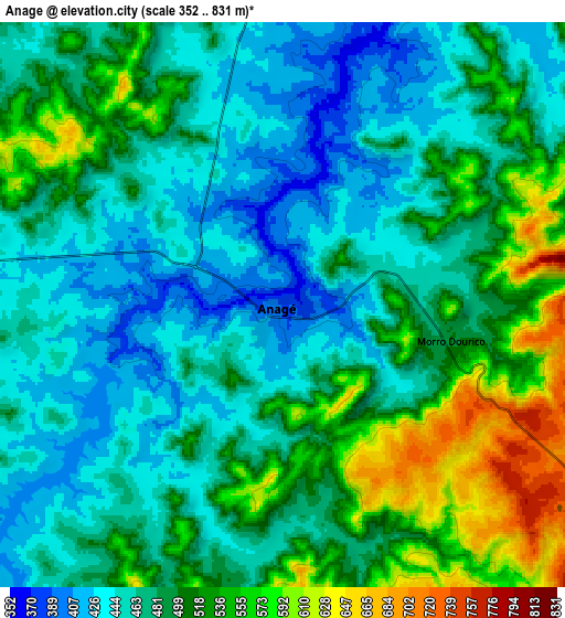
These maps also provides idea of topography and contour of this city, they are displayed at different zoom levels. More info about maps, scale and edge coordinates you can find below images.
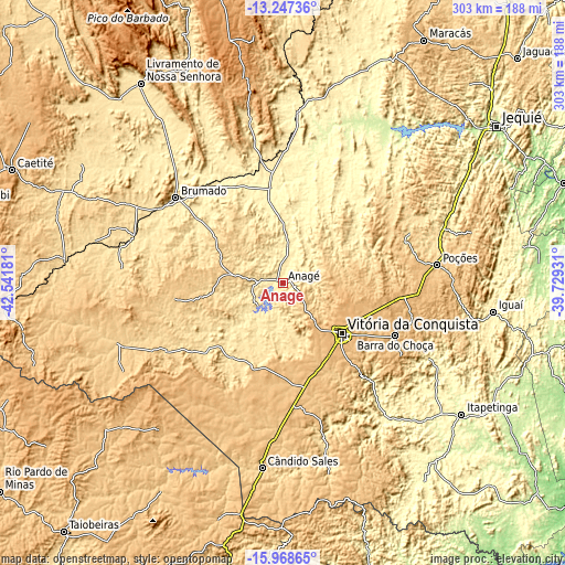
| \ | Map #1 | Map #2 | Topo.Map |
| Scale [m] | 360..722 m | 352..831 m | × |
| Scale [ft] | 1181..2369 ft | 1155..2726 ft | × |
| Average | 441.4 m = 1448 ft | 489.3 m = 1605 ft | × |
| Width | 9.46 km = 5.9 mi | 18.91 km = 11.8 mi | 302.6 km = 188 mi |
| Height | 9.46 km = 5.9 mi | 18.91 km = 11.8 mi | 302.6 km = 188 mi |
| ↑Max Latitude | -14.569692° | -14.527156° | -13.24736° |
| Latitude at center | -14.61222° | -14.61222° | -14.61222° |
| ↓Min Latitude | -14.65474° | -14.697251° | -15.96865° |
| ← Min Longitude | -41.179505° | -41.223451° | -42.54181° |
| Longitude center | -41.13556° | -41.13556° | -41.13556° |
| →Max Longitude | -41.091615° | -41.047669° | -39.72931° |
Nearby cities:
Cities around Anagé sort by population:
• Vitória da Conquista elevation 876 m
42.6 km,  131°
131°
• Brumado 427 m
72.9 km,  308°
308°
• Poções 764 m
83.4 km,  83°
83°
• Itambé 357 m
89.3 km,  142°
142°
• Iguaí 354 m
113.7 km,  98°
98°
• Santana 519 m
73.3 km,  282°
282°
• Barra da Estiva 1030 m
111.6 km,  349°
349°
• São Felipe 463 m
37.3 km,  227°
227°
• Tanhaçu 433 m
66.8 km, 349°
• Ituaçu 527 m
90.5 km, 348°
• Encruzilhada 627 m
105 km,  166°
166°
• Tremedal 514 m
50.1 km,  216°
216°
Multilingual:
 En español:
Anagé elevación 378 m.
 En France:
Anagé élévation 378 m.


Sources and notes:
- [note 1] Map square and city borders are not equal. Map elevation data is calculated only from area inside that square.
- [src 1] Elevation data from geonames database provided with same terms of usage.
- [src 2] The elevation map of Anagé is generated using elevation data from NASA's 3 arcsec (90m) resolution SRTM data.
- [src 3] Base (background) map © OpenStreetMap contributors tiles are generated by Geofabrik and OpenTopoMap.
Copyright & License:
This Anagé Elevation Map is licensed under CC BY-SA. You may reuse any part from this page, if you give a proper credit by linking to this URL:
 More info on terms of use page.