Tanhaçu elevation
Tanhaçu (Bahia), Brazil elevation is 433 meters and Tanhaçu elevation in feet is 1421 ft above sea level [src 1]. Tanhaçu is a populated place (feature code) with elevation that is 51 meters (167 ft) bigger than average city elevation in Brazil.
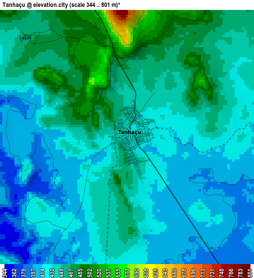
Below is the Elevation map of Tanhaçu, which displays elevation range with different colors. Scale of the first map is from 344 to 801 m (1129 to 2628 ft) with average elevation of 439.5 meters (=1442 ft) [note 1]
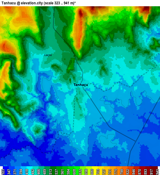
These maps also provides idea of topography and contour of this city, they are displayed at different zoom levels. More info about maps, scale and edge coordinates you can find below images.
| \ | Map #1 | Map #2 | Topo.Map |
| Scale [m] | 344..801 m | 323..941 m | × |
| Scale [ft] | 1129..2628 ft | 1060..3087 ft | × |
| Average | 439.5 m = 1442 ft | 470.3 m = 1543 ft | × |
| Width | 9.48 km = 5.9 mi | 18.96 km = 11.8 mi | 303.4 km = 188.5 mi |
| Height | 9.48 km = 5.9 mi | 18.96 km = 11.8 mi | 303.4 km = 188.5 mi |
| ↑Max Latitude | -13.97875° | -13.936102° | -12.6531° |
| Latitude at center | -14.02139° | -14.02139° | -14.02139° |
| ↓Min Latitude | -14.064022° | -14.106646° | -15.38156° |
| ← Min Longitude | -41.292005° | -41.335951° | -42.65431° |
| Longitude center | -41.24806° | -41.24806° | -41.24806° |
| →Max Longitude | -41.204115° | -41.160169° | -39.84181° |
Nearby cities:
Cities around Tanhaçu sort by population:
• Vitória da Conquista elevation 876 m
103.7 km,  154°
154°
• Brumado 427 m
49.3 km,  245°
245°
• Poções 764 m
110.6 km,  120°
120°
• Maracás 963 m
109.3 km,  53°
53°
• Livramento do Brumado 465 m
76.5 km,  302°
302°
• Santana 519 m
77.4 km,  230°
230°
• Barra da Estiva 1030 m
44.8 km,  349°
349°
• Caculé 584 m
117.9 km,  242°
242°
• São Felipe 463 m
92.2 km,  189°
189°
• Ituaçu 527 m
23.7 km, 347°
• Anagé 378 m
66.8 km,  169°
169°
• Tremedal 514 m
107.6 km, 189°
Multilingual:
 En español:
Tanhaçu elevación 433 m.
 En France:
Tanhaçu élévation 433 m.


Sources and notes:
- [note 1] Map square and city borders are not equal. Map elevation data is calculated only from area inside that square.
- [src 1] Elevation data from geonames database provided with same terms of usage.
- [src 2] The elevation map of Tanhaçu is generated using elevation data from NASA's 3 arcsec (90m) resolution SRTM data.
- [src 3] Base (background) map © OpenStreetMap contributors tiles are generated by Geofabrik and OpenTopoMap.
Copyright & License:
This Tanhaçu Elevation Map is licensed under CC BY-SA. You may reuse any part from this page, if you give a proper credit by linking to this URL:
 More info on terms of use page.