Água Preta elevation
Água Preta (Pernambuco), Brazil elevation is 133 meters and Água Preta elevation in feet is 436 ft above sea level [src 1]. Água Preta is a populated place (feature code) with elevation that is 249 meters (817 ft) smaller than average city elevation in Brazil.
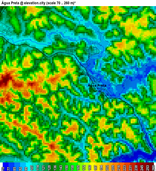
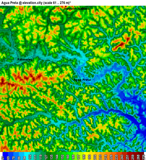
Below is the Elevation map of Água Preta, which displays elevation range with different colors. Scale of the first map is from 70 to 260 m (230 to 853 ft) with average elevation of 141.5 meters (=464 ft) [note 1]
These maps also provides idea of topography and contour of this city, they are displayed at different zoom levels. More info about maps, scale and edge coordinates you can find below images.
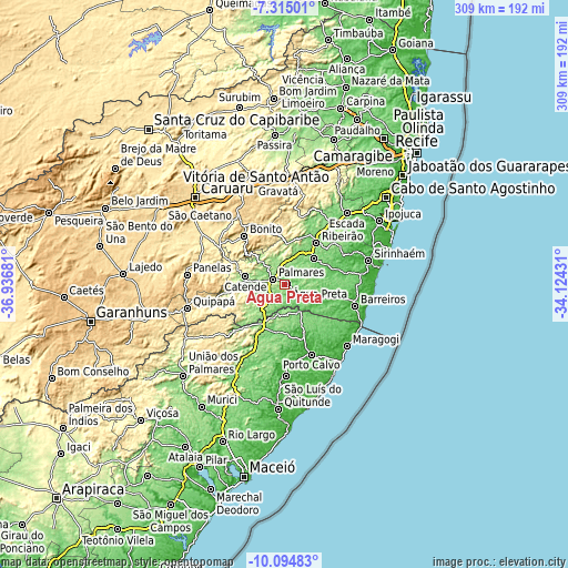
| \ | Map #1 | Map #2 | Topo.Map |
| Scale [m] | 70..260 m | 61..276 m | × |
| Scale [ft] | 230..853 ft | 200..906 ft | × |
| Average | 141.5 m = 464 ft | 145 m = 476 ft | × |
| Width | 9.66 km = 6 mi | 19.32 km = 12 mi | 309.1 km = 192.1 mi |
| Height | 9.66 km = 6 mi | 19.32 km = 12 mi | 309.1 km = 192.1 mi |
| ↑Max Latitude | -8.664059° | -8.620612° | -7.31501° |
| Latitude at center | -8.7075° | -8.7075° | -8.7075° |
| ↓Min Latitude | -8.750936° | -8.794367° | -10.09483° |
| ← Min Longitude | -35.574505° | -35.618451° | -36.93681° |
| Longitude center | -35.53056° | -35.53056° | -35.53056° |
| →Max Longitude | -35.486615° | -35.442669° | -34.12431° |
Nearby cities:
Cities around Água Preta sort by population:
• Palmares elevation 115 m
7.2 km,  291°
291°
• Ribeirão 128 m
27.3 km,  38°
38°
• Catende 172 m
21 km,  282°
282°
• Gameleira 100 m
20.9 km,  49°
49°
• Amaraji 262 m
37.1 km,  13°
13°
• Maraial 252 m
31.7 km,  254°
254°
• Colônia Leopoldina 133 m
30.9 km,  223°
223°
• Joaquim Nabuco 151 m
9.2 km,  358°
358°
• Guabiraba 481 m
35.6 km,  335°
335°
• Bonito 441 m
34.2 km,  320°
320°
• Novo Lino 187 m
26.4 km,  208°
208°
• Jundiá 114 m
25.7 km,  190°
190°
Multilingual:
 En español:
Água Preta elevación 133 m.
 En France:
Água Preta élévation 133 m.
 Auf Deutsch:
Água Preta höhe über dem Meeresspiegel ist 133 m.

Sources and notes:
- [note 1] Map square and city borders are not equal. Map elevation data is calculated only from area inside that square.
- [src 1] Elevation data from geonames database provided with same terms of usage.
- [src 2] The elevation map of Água Preta is generated using elevation data from NASA's 3 arcsec (90m) resolution SRTM data.
- [src 3] Base (background) map © OpenStreetMap contributors tiles are generated by Geofabrik and OpenTopoMap.
Copyright & License:
This Água Preta Elevation Map is licensed under CC BY-SA. You may reuse any part from this page, if you give a proper credit by linking to this URL:
 More info on terms of use page.