Guabiraba elevation
Guabiraba (Pernambuco, Barra de Guabiraba), Brazil elevation is 481 meters and Guabiraba elevation in feet is 1578 ft above sea level [src 1]. Guabiraba is a populated place (feature code) with elevation that is 99 meters (325 ft) bigger than average city elevation in Brazil.
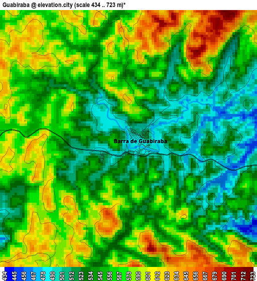
Below is the Elevation map of Guabiraba, which displays elevation range with different colors. Scale of the first map is from 434 to 723 m (1424 to 2372 ft) with average elevation of 558.7 meters (=1833 ft) [note 1]
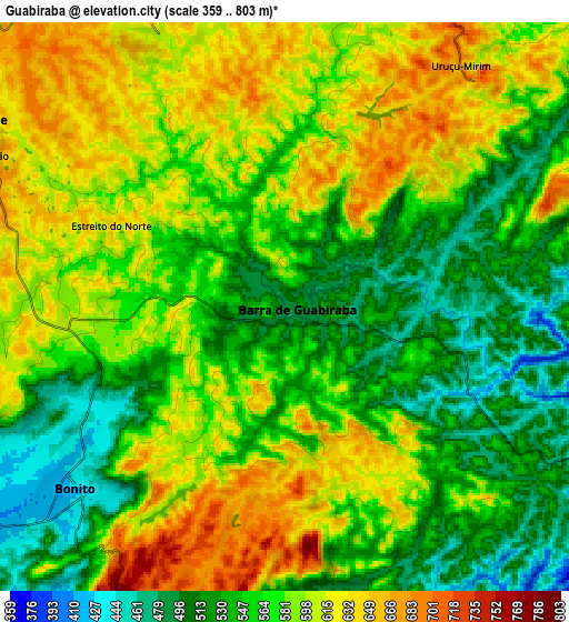
These maps also provides idea of topography and contour of this city, they are displayed at different zoom levels. More info about maps, scale and edge coordinates you can find below images.
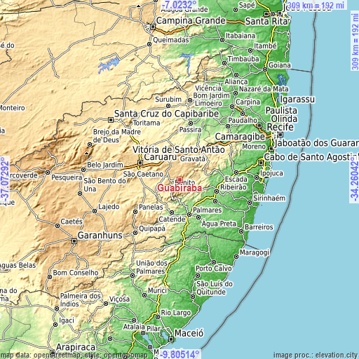
| \ | Map #1 | Map #2 | Topo.Map |
| Scale [m] | 434..723 m | 359..803 m | × |
| Scale [ft] | 1424..2372 ft | 1178..2635 ft | × |
| Average | 558.7 m = 1833 ft | 573.5 m = 1882 ft | × |
| Width | 9.67 km = 6 mi | 19.33 km = 12 mi | 309.3 km = 192.2 mi |
| Height | 9.67 km = 6 mi | 19.33 km = 12 mi | 309.4 km = 192.3 mi |
| ↑Max Latitude | -8.373196° | -8.329716° | -7.0232° |
| Latitude at center | -8.41667° | -8.41667° | -8.41667° |
| ↓Min Latitude | -8.46014° | -8.503604° | -9.80514° |
| ← Min Longitude | -35.710615° | -35.754561° | -37.07292° |
| Longitude center | -35.66667° | -35.66667° | -35.66667° |
| →Max Longitude | -35.622725° | -35.578779° | -34.26042° |
Nearby cities:
Cities around Guabiraba sort by population:
• Gravatá elevation 458 m
26.5 km,  25°
25°
• Bezerros 501 m
24.9 km,  324°
324°
• Palmares 115 m
30.8 km,  164°
164°
• Ribeirão 128 m
33.6 km,  108°
108°
• Catende 172 m
28.3 km,  191°
191°
• Chã Grande 471 m
30 km,  48°
48°
• Amaraji 262 m
23.9 km,  80°
80°
• Agrestina 432 m
30.9 km,  261°
261°
• São Joaquim do Monte 483 m
15.3 km, 263°
• Camocim de São Félix 674 m
12.3 km,  301°
301°
• Joaquim Nabuco 151 m
27.4 km,  147°
147°
• Bonito 441 m
9.1 km,  228°
228°
Multilingual:
 En español:
Guabiraba elevación 481 m.
 En France:
Guabiraba élévation 481 m.
 Auf Deutsch:
Guabiraba höhe über dem Meeresspiegel ist 481 m.

Sources and notes:
- [note 1] Map square and city borders are not equal. Map elevation data is calculated only from area inside that square.
- [src 1] Elevation data from geonames database provided with same terms of usage.
- [src 2] The elevation map of Guabiraba is generated using elevation data from NASA's 3 arcsec (90m) resolution SRTM data.
- [src 3] Base (background) map © OpenStreetMap contributors tiles are generated by Geofabrik and OpenTopoMap.
Copyright & License:
This Guabiraba Elevation Map is licensed under CC BY-SA. You may reuse any part from this page, if you give a proper credit by linking to this URL:
 More info on terms of use page.