Gravatá elevation
Gravatá (Pernambuco), Brazil elevation is 458 meters and Gravatá elevation in feet is 1503 ft above sea level [src 1]. Gravatá is a populated place (feature code) with elevation that is 76 meters (249 ft) bigger than average city elevation in Brazil.
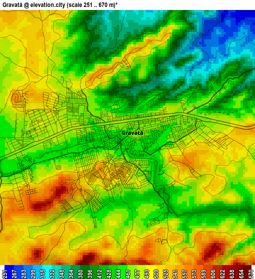
Below is the Elevation map of Gravatá, which displays elevation range with different colors. Scale of the first map is from 251 to 670 m (823 to 2198 ft) with average elevation of 465.1 meters (=1526 ft) [note 1]
These maps also provides idea of topography and contour of this city, they are displayed at different zoom levels. More info about maps, scale and edge coordinates you can find below images.
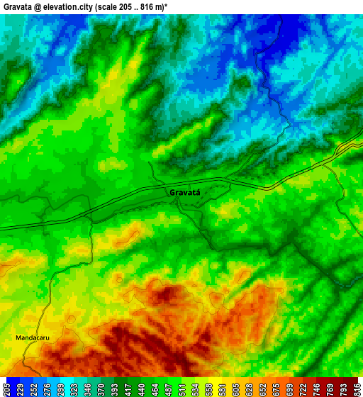
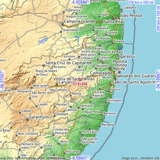
| \ | Map #1 | Map #2 | Topo.Map |
| Scale [m] | 251..670 m | 205..816 m | × |
| Scale [ft] | 823..2198 ft | 673..2677 ft | × |
| Average | 465.1 m = 1526 ft | 466.1 m = 1529 ft | × |
| Width | 9.67 km = 6 mi | 19.35 km = 12 mi | 309.5 km = 192.3 mi |
| Height | 9.67 km = 6 mi | 19.35 km = 12 mi | 309.5 km = 192.3 mi |
| ↑Max Latitude | -8.157612° | -8.114109° | -6.80694° |
| Latitude at center | -8.20111° | -8.20111° | -8.20111° |
| ↓Min Latitude | -8.244604° | -8.288092° | -9.59041° |
| ← Min Longitude | -35.608665° | -35.652611° | -36.97097° |
| Longitude center | -35.56472° | -35.56472° | -35.56472° |
| →Max Longitude | -35.520775° | -35.476829° | -34.15847° |
Nearby cities:
Cities around Gravatá sort by population:
• Vitória de Santo Antão elevation 156 m
31.5 km,  72°
72°
• Bezerros 501 m
25.8 km,  262°
262°
• Chã Grande 471 m
12.1 km,  110°
110°
• Amaraji 262 m
23.7 km,  148°
148°
• Pombos 206 m
19.7 km, 70°
• São Joaquim do Monte 483 m
36.8 km,  225°
225°
• Feira Nova 163 m
33.9 km,  34°
34°
• Passira 188 m
23 km,  355°
355°
• Camocim de São Félix 674 m
27.9 km, 231°
• Guabiraba 481 m
26.5 km,  205°
205°
• Bonito 441 m
34.9 km, 211°
• Cumaru 362 m
26.1 km,  326°
326°
Multilingual:
 En español:
Gravatá elevación 458 m.
 En France:
Gravatá élévation 458 m.


Sources and notes:
- [note 1] Map square and city borders are not equal. Map elevation data is calculated only from area inside that square.
- [src 1] Elevation data from geonames database provided with same terms of usage.
- [src 2] The elevation map of Gravatá is generated using elevation data from NASA's 3 arcsec (90m) resolution SRTM data.
- [src 3] Base (background) map © OpenStreetMap contributors tiles are generated by Geofabrik and OpenTopoMap.
Copyright & License:
This Gravatá Elevation Map is licensed under CC BY-SA. You may reuse any part from this page, if you give a proper credit by linking to this URL:
 More info on terms of use page.