Pombos elevation
Pombos (Pernambuco), Brazil elevation is 206 meters and Pombos elevation in feet is 676 ft above sea level [src 1]. Pombos is a populated place (feature code) with elevation that is 176 meters (577 ft) smaller than average city elevation in Brazil.
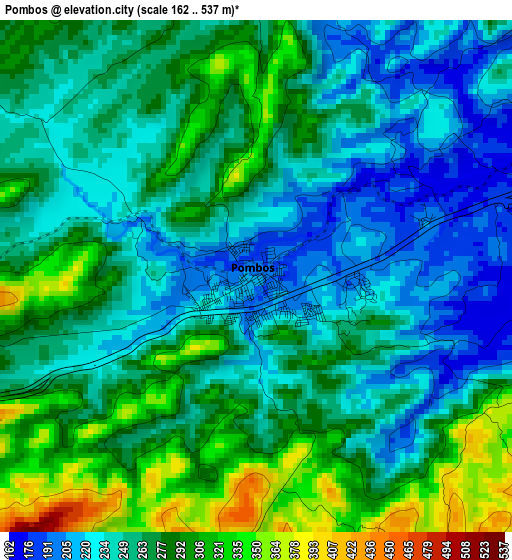
Below is the Elevation map of Pombos, which displays elevation range with different colors. Scale of the first map is from 162 to 537 m (531 to 1762 ft) with average elevation of 263.7 meters (=865 ft) [note 1]
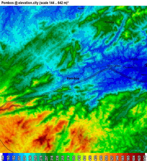
These maps also provides idea of topography and contour of this city, they are displayed at different zoom levels. More info about maps, scale and edge coordinates you can find below images.
| \ | Map #1 | Map #2 | Topo.Map |
| Scale [m] | 162..537 m | 144..642 m | × |
| Scale [ft] | 531..1762 ft | 472..2106 ft | × |
| Average | 263.7 m = 865 ft | 308.1 m = 1011 ft | × |
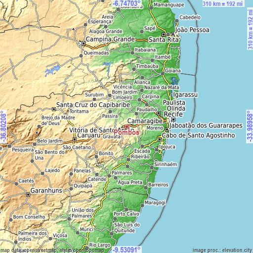
| Width | 9.67 km = 6 mi | 19.35 km = 12 mi | 309.5 km = 192.3 mi |
| Height | 9.67 km = 6 mi | 19.35 km = 12 mi | 309.6 km = 192.4 mi |
| ↑Max Latitude | -8.097885° | -8.054376° | -6.74703° |
| Latitude at center | -8.14139° | -8.14139° | -8.14139° |
| ↓Min Latitude | -8.18489° | -8.228385° | -9.53091° |
| ← Min Longitude | -35.439775° | -35.483721° | -36.80208° |
| Longitude center | -35.39583° | -35.39583° | -35.39583° |
| →Max Longitude | -35.351885° | -35.307939° | -33.98958° |
Nearby cities:
Cities around Pombos sort by population:
• Vitória de Santo Antão elevation 156 m
11.8 km,  77°
77°
• Carpina 186 m
35.8 km,  25°
25°
• Gravatá 458 m
19.7 km,  250°
250°
• Escada 117 m
30.7 km,  141°
141°
• Moreno 78 m
33.5 km,  85°
85°
• Limoeiro 142 m
30.3 km,  348°
348°
• Lagoa do Itaenga 187 m
25.6 km, 26°
• Glória do Goitá 155 m
19.2 km,  36°
36°
• Chã Grande 471 m
13 km,  213°
213°
• Amaraji 262 m
27.6 km,  193°
193°
• Feira Nova 163 m
21.2 km,  1°
1°
• Passira 188 m
26 km,  308°
308°
Multilingual:
 En español:
Pombos elevación 206 m.
 En France:
Pombos élévation 206 m.


Sources and notes:
- [note 1] Map square and city borders are not equal. Map elevation data is calculated only from area inside that square.
- [src 1] Elevation data from geonames database provided with same terms of usage.
- [src 2] The elevation map of Pombos is generated using elevation data from NASA's 3 arcsec (90m) resolution SRTM data.
- [src 3] Base (background) map © OpenStreetMap contributors tiles are generated by Geofabrik and OpenTopoMap.
Copyright & License:
This Pombos Elevation Map is licensed under CC BY-SA. You may reuse any part from this page, if you give a proper credit by linking to this URL:
 More info on terms of use page.