Limoeiro elevation
Limoeiro (Pernambuco), Brazil elevation is 142 meters and Limoeiro elevation in feet is 466 ft above sea level [src 1]. Limoeiro is a populated place (feature code) with elevation that is 240 meters (787 ft) smaller than average city elevation in Brazil.
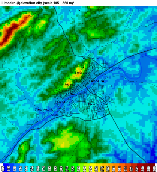
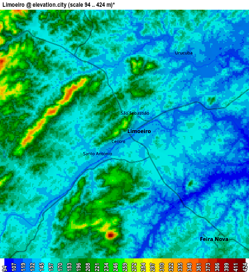
Below is the Elevation map of Limoeiro, which displays elevation range with different colors. Scale of the first map is from 105 to 360 m (344 to 1181 ft) with average elevation of 163.8 meters (=537 ft) [note 1]
These maps also provides idea of topography and contour of this city, they are displayed at different zoom levels. More info about maps, scale and edge coordinates you can find below images.
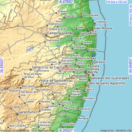
| \ | Map #1 | Map #2 | Topo.Map |
| Scale [m] | 105..360 m | 94..424 m | × |
| Scale [ft] | 344..1181 ft | 308..1391 ft | × |
| Average | 163.8 m = 537 ft | 164 m = 538 ft | × |
| Width | 9.68 km = 6 mi | 19.36 km = 12 mi | 309.7 km = 192.4 mi |
| Height | 9.68 km = 6 mi | 19.36 km = 12 mi | 309.8 km = 192.5 mi |
| ↑Max Latitude | -7.831187° | -7.787649° | -6.47952° |
| Latitude at center | -7.87472° | -7.87472° | -7.87472° |
| ↓Min Latitude | -7.918249° | -7.961773° | -9.26523° |
| ← Min Longitude | -35.494225° | -35.538171° | -36.85653° |
| Longitude center | -35.45028° | -35.45028° | -35.45028° |
| →Max Longitude | -35.406335° | -35.362389° | -34.04403° |
Nearby cities:
Cities around Limoeiro sort by population:
• Carpina elevation 186 m
21.7 km,  82°
82°
• Nazaré da Mata 96 m
28.6 km,  58°
58°
• Lagoa do Itaenga 187 m
18.9 km,  111°
111°
• Glória do Goitá 155 m
22.4 km,  129°
129°
• Pombos 206 m
30.3 km,  168°
168°
• Bom Jardim 306 m
17.4 km,  300°
300°
• Feira Nova 163 m
10.8 km,  141°
141°
• Passira 188 m
19.6 km,  227°
227°
• João Alfredo 345 m
15.3 km,  277°
277°
• Vicência 122 m
27.8 km,  29°
29°
• Orobó 392 m
22.1 km,  310°
310°
• Natuba 343 m
28.2 km,  337°
337°
Multilingual:
 En español:
Limoeiro elevación 142 m.
 En France:
Limoeiro élévation 142 m.
 Auf Deutsch:
Limoeiro höhe über dem Meeresspiegel ist 142 m.

Sources and notes:
- [note 1] Map square and city borders are not equal. Map elevation data is calculated only from area inside that square.
- [src 1] Elevation data from geonames database provided with same terms of usage.
- [src 2] The elevation map of Limoeiro is generated using elevation data from NASA's 3 arcsec (90m) resolution SRTM data.
- [src 3] Base (background) map © OpenStreetMap contributors tiles are generated by Geofabrik and OpenTopoMap.
Copyright & License:
This Limoeiro Elevation Map is licensed under CC BY-SA. You may reuse any part from this page, if you give a proper credit by linking to this URL:
 More info on terms of use page.