Lagoa do Itaenga elevation
Lagoa do Itaenga (Pernambuco, Lagoa de Itaenga), Brazil elevation is 187 meters and Lagoa do Itaenga elevation in feet is 614 ft above sea level [src 1]. Lagoa do Itaenga is a populated place (feature code) with elevation that is 195 meters (640 ft) smaller than average city elevation in Brazil.
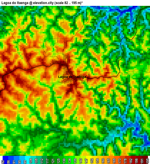
Below is the Elevation map of Lagoa do Itaenga, which displays elevation range with different colors. Scale of the first map is from 82 to 195 m (269 to 640 ft) with average elevation of 139.4 meters (=457 ft) [note 1]
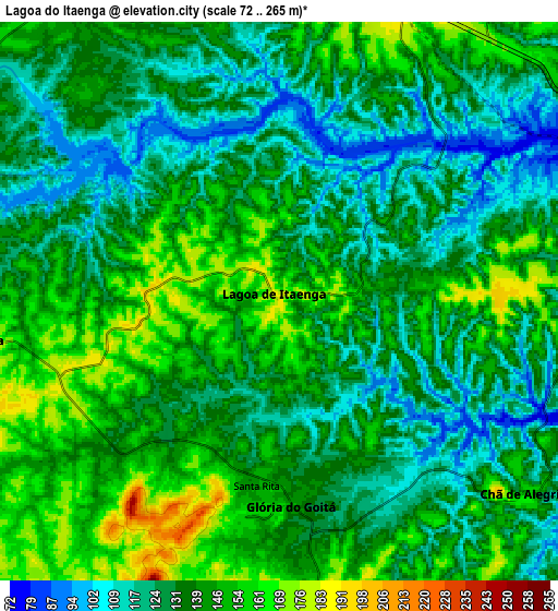
These maps also provides idea of topography and contour of this city, they are displayed at different zoom levels. More info about maps, scale and edge coordinates you can find below images.
| \ | Map #1 | Map #2 | Topo.Map |
| Scale [m] | 82..195 m | 72..265 m | × |
| Scale [ft] | 269..640 ft | 236..869 ft | × |
| Average | 139.4 m = 457 ft | 136.7 m = 448 ft | × |
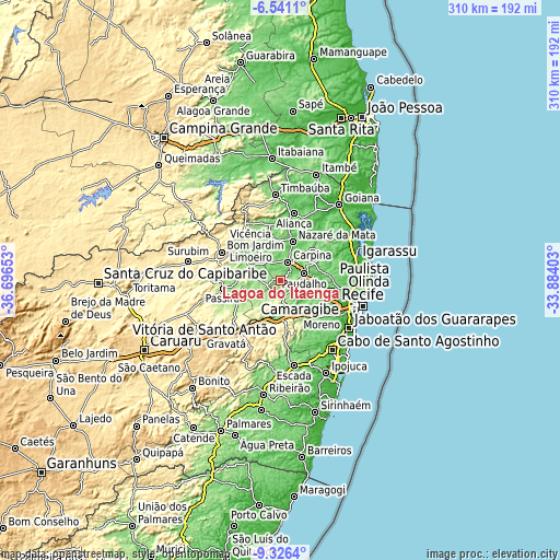
| Width | 9.68 km = 6 mi | 19.36 km = 12 mi | 309.7 km = 192.4 mi |
| Height | 9.68 km = 6 mi | 19.36 km = 12 mi | 309.7 km = 192.4 mi |
| ↑Max Latitude | -7.892583° | -7.849052° | -6.5411° |
| Latitude at center | -7.93611° | -7.93611° | -7.93611° |
| ↓Min Latitude | -7.979632° | -8.02315° | -9.3264° |
| ← Min Longitude | -35.334225° | -35.378171° | -36.69653° |
| Longitude center | -35.29028° | -35.29028° | -35.29028° |
| →Max Longitude | -35.246335° | -35.202389° | -33.88403° |
Nearby cities:
Cities around Lagoa do Itaenga sort by population:
• Vitória de Santo Antão elevation 156 m
20.2 km,  180°
180°
• São Lourenço da Mata 48 m
30.8 km,  103°
103°
• Carpina 186 m
10.3 km,  22°
22°
• Moreno 78 m
29.8 km,  132°
132°
• Limoeiro 142 m
18.9 km,  291°
291°
• Nazaré da Mata 96 m
22.7 km, 17°
• Glória do Goitá 155 m
7.3 km, 182°
• Pombos 206 m
25.6 km,  206°
206°
• Araçoiaba 166 m
27.3 km,  53°
53°
• Feira Nova 163 m
11 km,  261°
261°
• Passira 188 m
32.6 km, 258°
• Vicência 122 m
31.3 km,  352°
352°
Multilingual:
 En español:
Lagoa do Itaenga elevación 187 m.
 En France:
Lagoa do Itaenga élévation 187 m.
 Auf Deutsch:
Lagoa do Itaenga höhe über dem Meeresspiegel ist 187 m.

Sources and notes:
- [note 1] Map square and city borders are not equal. Map elevation data is calculated only from area inside that square.
- [src 1] Elevation data from geonames database provided with same terms of usage.
- [src 2] The elevation map of Lagoa do Itaenga is generated using elevation data from NASA's 3 arcsec (90m) resolution SRTM data.
- [src 3] Base (background) map © OpenStreetMap contributors tiles are generated by Geofabrik and OpenTopoMap.
Copyright & License:
This Lagoa do Itaenga Elevation Map is licensed under CC BY-SA. You may reuse any part from this page, if you give a proper credit by linking to this URL:
 More info on terms of use page.