Orobó elevation
Orobó (Pernambuco), Brazil elevation is 392 meters and Orobó elevation in feet is 1286 ft above sea level [src 1]. Orobó is a populated place (feature code) with elevation that is 10 meters (33 ft) bigger than average city elevation in Brazil.
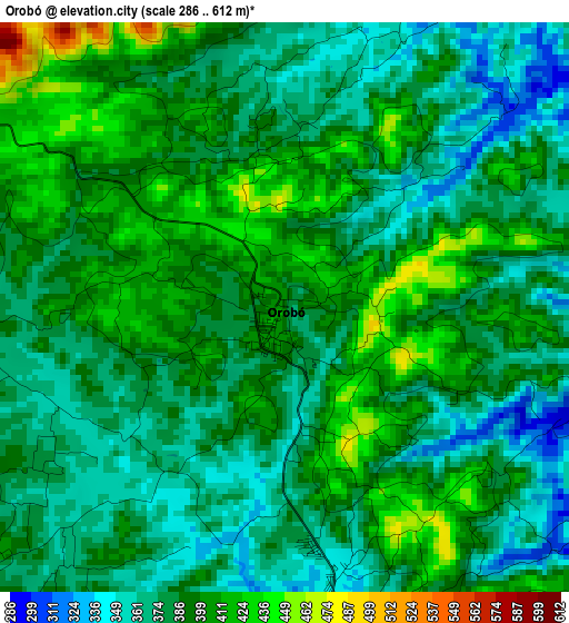
Below is the Elevation map of Orobó, which displays elevation range with different colors. Scale of the first map is from 286 to 612 m (938 to 2008 ft) with average elevation of 387.3 meters (=1271 ft) [note 1]
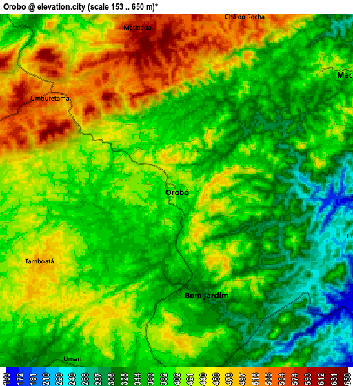
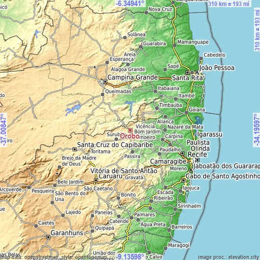
These maps also provides idea of topography and contour of this city, they are displayed at different zoom levels. More info about maps, scale and edge coordinates you can find below images.
| \ | Map #1 | Map #2 | Topo.Map |
| Scale [m] | 286..612 m | 153..650 m | × |
| Scale [ft] | 938..2008 ft | 502..2133 ft | × |
| Average | 387.3 m = 1271 ft | 395.7 m = 1298 ft | × |
| Width | 9.68 km = 6 mi | 19.37 km = 12 mi | 309.8 km = 192.5 mi |
| Height | 9.68 km = 6 mi | 19.37 km = 12 mi | 309.9 km = 192.6 mi |
| ↑Max Latitude | -7.701453° | -7.657902° | -6.34941° |
| Latitude at center | -7.745° | -7.745° | -7.745° |
| ↓Min Latitude | -7.788542° | -7.83208° | -9.13598° |
| ← Min Longitude | -35.646165° | -35.690111° | -37.00847° |
| Longitude center | -35.60222° | -35.60222° | -35.60222° |
| →Max Longitude | -35.558275° | -35.514329° | -34.19597° |
Nearby cities:
Cities around Orobó sort by population:
• Limoeiro elevation 142 m
22.1 km,  130°
130°
• Surubim 377 m
19.4 km,  239°
239°
• Macaparana 347 m
26.8 km,  37°
37°
• Bom Jardim 306 m
5.9 km,  163°
163°
• Feira Nova 163 m
32.8 km, 134°
• Passira 188 m
27.9 km,  175°
175°
• João Alfredo 345 m
12.4 km,  172°
172°
• Vicência 122 m
31.9 km,  72°
72°
• Aroeiras 341 m
25.1 km,  332°
332°
• Cumaru 362 m
30.9 km,  199°
199°
• Umbuzeiro 527 m
8.7 km,  309°
309°
• Natuba 343 m
12.9 km,  26°
26°
Multilingual:
 En español:
Orobó elevación 392 m.
 En France:
Orobó élévation 392 m.


Sources and notes:
- [note 1] Map square and city borders are not equal. Map elevation data is calculated only from area inside that square.
- [src 1] Elevation data from geonames database provided with same terms of usage.
- [src 2] The elevation map of Orobó is generated using elevation data from NASA's 3 arcsec (90m) resolution SRTM data.
- [src 3] Base (background) map © OpenStreetMap contributors tiles are generated by Geofabrik and OpenTopoMap.
Copyright & License:
This Orobó Elevation Map is licensed under CC BY-SA. You may reuse any part from this page, if you give a proper credit by linking to this URL:
 More info on terms of use page.