Colônia Leopoldina elevation
Colônia Leopoldina (Pernambuco, Manari), Brazil elevation is 133 meters and Colônia Leopoldina elevation in feet is 436 ft above sea level [src 1]. Colônia Leopoldina is a populated place (feature code) with elevation that is 249 meters (817 ft) smaller than average city elevation in Brazil.
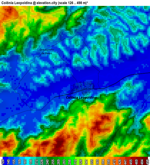
Below is the Elevation map of Colônia Leopoldina, which displays elevation range with different colors. Scale of the first map is from 126 to 498 m (413 to 1634 ft) with average elevation of 227.4 meters (=746 ft) [note 1]
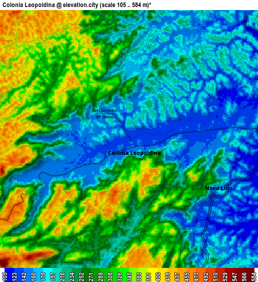
These maps also provides idea of topography and contour of this city, they are displayed at different zoom levels. More info about maps, scale and edge coordinates you can find below images.
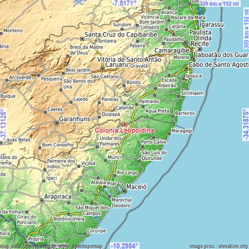
| \ | Map #1 | Map #2 | Topo.Map |
| Scale [m] | 126..498 m | 105..584 m | × |
| Scale [ft] | 413..1634 ft | 344..1916 ft | × |
| Average | 227.4 m = 746 ft | 250.2 m = 821 ft | × |
| Width | 9.65 km = 6 mi | 19.31 km = 12 mi | 308.9 km = 191.9 mi |
| Height | 9.65 km = 6 mi | 19.31 km = 12 mi | 308.9 km = 191.9 mi |
| ↑Max Latitude | -8.865472° | -8.822049° | -7.5171° |
| Latitude at center | -8.90889° | -8.90889° | -8.90889° |
| ↓Min Latitude | -8.952303° | -8.99571° | -10.2954° |
| ← Min Longitude | -35.768945° | -35.812891° | -37.13125° |
| Longitude center | -35.725° | -35.725° | -35.725° |
| →Max Longitude | -35.681055° | -35.637109° | -34.31875° |
Nearby cities:
Cities around Colônia Leopoldina sort by population:
• Palmares elevation 115 m
29 km,  30°
30°
• Catende 172 m
26.9 km,  1°
1°
• Matriz de Camaragibe 10 m
34.2 km,  142°
142°
• Água Preta 133 m
30.9 km,  43°
43°
• Maraial 252 m
16.8 km,  326°
326°
• São José da Laje 265 m
38.3 km,  252°
252°
• Quipapá 458 m
32.8 km,  285°
285°
• Joaquim Nabuco 151 m
38 km, 33°
• Ibateguara 440 m
24.6 km, 253°
• Flexeiras 132 m
32.7 km,  190°
190°
• Novo Lino 187 m
8.6 km,  94°
94°
• Jundiá 114 m
16.9 km,  99°
99°
Multilingual:
 En español:
Colônia Leopoldina elevación 133 m.
 En France:
Colônia Leopoldina élévation 133 m.
 Auf Deutsch:
Colônia Leopoldina höhe über dem Meeresspiegel ist 133 m.
 На русском:
Colônia Leopoldina высота над уровнем моря 133 м
Sources and notes:
- [note 1] Map square and city borders are not equal. Map elevation data is calculated only from area inside that square.
- [src 1] Elevation data from geonames database provided with same terms of usage.
- [src 2] The elevation map of Colônia Leopoldina is generated using elevation data from NASA's 3 arcsec (90m) resolution SRTM data.
- [src 3] Base (background) map © OpenStreetMap contributors tiles are generated by Geofabrik and OpenTopoMap.
Copyright & License:
This Colônia Leopoldina Elevation Map is licensed under CC BY-SA. You may reuse any part from this page, if you give a proper credit by linking to this URL:
 More info on terms of use page.