Quipapá elevation
Quipapá (Pernambuco), Brazil elevation is 458 meters and Quipapá elevation in feet is 1503 ft above sea level [src 1]. Quipapá is a populated place (feature code) with elevation that is 76 meters (249 ft) bigger than average city elevation in Brazil.
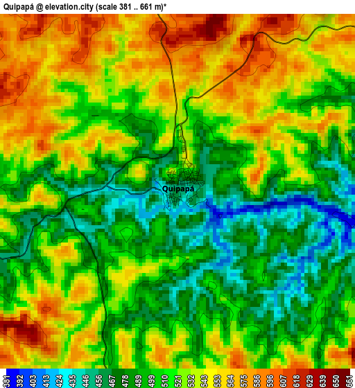
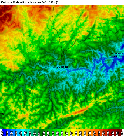
Below is the Elevation map of Quipapá, which displays elevation range with different colors. Scale of the first map is from 381 to 661 m (1250 to 2169 ft) with average elevation of 518.6 meters (=1701 ft) [note 1]
These maps also provides idea of topography and contour of this city, they are displayed at different zoom levels. More info about maps, scale and edge coordinates you can find below images.
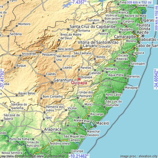
| \ | Map #1 | Map #2 | Topo.Map |
| Scale [m] | 381..661 m | 345..851 m | × |
| Scale [ft] | 1250..2169 ft | 1132..2792 ft | × |
| Average | 518.6 m = 1701 ft | 570.2 m = 1871 ft | × |
| Width | 9.66 km = 6 mi | 19.31 km = 12 mi | 309 km = 192 mi |
| Height | 9.66 km = 6 mi | 19.31 km = 12 mi | 309 km = 192 mi |
| ↑Max Latitude | -8.784353° | -8.74092° | -7.4357° |
| Latitude at center | -8.82778° | -8.82778° | -8.82778° |
| ↓Min Latitude | -8.871202° | -8.914619° | -10.21462° |
| ← Min Longitude | -36.055615° | -36.099561° | -37.41792° |
| Longitude center | -36.01167° | -36.01167° | -36.01167° |
| →Max Longitude | -35.967725° | -35.923779° | -34.60542° |
Nearby cities:
Cities around Quipapá sort by population:
• União dos Palmares elevation 154 m
37.3 km,  183°
183°
• Lajedo 672 m
38.5 km,  298°
298°
• Catende 172 m
37 km,  61°
61°
• Cupira 430 m
24.4 km,  16°
16°
• Maraial 252 m
22.8 km,  77°
77°
• São José da Laje 265 m
20.9 km,  194°
194°
• Canhotinho 529 m
20.6 km,  252°
252°
• Altinho 458 m
38 km,  352°
352°
• Colônia Leopoldina 133 m
32.8 km,  105°
105°
• Ibateguara 440 m
17.9 km,  153°
153°
• São João 712 m
39.4 km,  262°
262°
• Novo Lino 187 m
41.3 km,  103°
103°
Multilingual:
 En español:
Quipapá elevación 458 m.
 En France:
Quipapá élévation 458 m.


Sources and notes:
- [note 1] Map square and city borders are not equal. Map elevation data is calculated only from area inside that square.
- [src 1] Elevation data from geonames database provided with same terms of usage.
- [src 2] The elevation map of Quipapá is generated using elevation data from NASA's 3 arcsec (90m) resolution SRTM data.
- [src 3] Base (background) map © OpenStreetMap contributors tiles are generated by Geofabrik and OpenTopoMap.
Copyright & License:
This Quipapá Elevation Map is licensed under CC BY-SA. You may reuse any part from this page, if you give a proper credit by linking to this URL:
 More info on terms of use page.