Altinho elevation
Altinho (Pernambuco), Brazil elevation is 458 meters and Altinho elevation in feet is 1503 ft above sea level [src 1]. Altinho is a populated place (feature code) with elevation that is 76 meters (249 ft) bigger than average city elevation in Brazil.
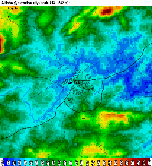
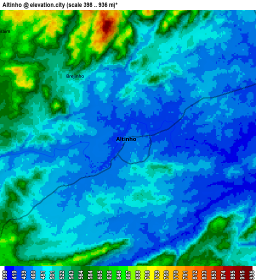
Below is the Elevation map of Altinho, which displays elevation range with different colors. Scale of the first map is from 413 to 582 m (1355 to 1909 ft) with average elevation of 459.4 meters (=1507 ft) [note 1]
These maps also provides idea of topography and contour of this city, they are displayed at different zoom levels. More info about maps, scale and edge coordinates you can find below images.
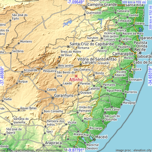
| \ | Map #1 | Map #2 | Topo.Map |
| Scale [m] | 413..582 m | 398..936 m | × |
| Scale [ft] | 1355..1909 ft | 1306..3071 ft | × |
| Average | 459.4 m = 1507 ft | 502.5 m = 1649 ft | × |
| Width | 9.67 km = 6 mi | 19.33 km = 12 mi | 309.3 km = 192.2 mi |
| Height | 9.67 km = 6 mi | 19.33 km = 12 mi | 309.3 km = 192.2 mi |
| ↑Max Latitude | -8.446254° | -8.402783° | -7.09649° |
| Latitude at center | -8.48972° | -8.48972° | -8.48972° |
| ↓Min Latitude | -8.533181° | -8.576638° | -9.87791° |
| ← Min Longitude | -36.103385° | -36.147331° | -37.46569° |
| Longitude center | -36.05944° | -36.05944° | -36.05944° |
| →Max Longitude | -36.015495° | -35.971549° | -34.65319° |
Nearby cities:
Cities around Altinho sort by population:
• Caruaru elevation 568 m
24.7 km,  21°
21°
• Bezerros 501 m
40.6 km,  45°
45°
• Lajedo 672 m
34.6 km,  235°
235°
• Catende 172 m
42.5 km,  117°
117°
• Cupira 430 m
18.5 km,  139°
139°
• Agrestina 432 m
13.1 km,  74°
74°
• Maraial 252 m
42.6 km, 139°
• São Joaquim do Monte 483 m
28.8 km,  77°
77°
• Cachoeirinha 530 m
19.1 km,  271°
271°
• Quipapá 458 m
38 km,  172°
172°
• Camocim de São Félix 674 m
35.8 km, 65°
• Bonito 441 m
36.4 km,  86°
86°
Multilingual:
 En español:
Altinho elevación 458 m.
 En France:
Altinho élévation 458 m.


Sources and notes:
- [note 1] Map square and city borders are not equal. Map elevation data is calculated only from area inside that square.
- [src 1] Elevation data from geonames database provided with same terms of usage.
- [src 2] The elevation map of Altinho is generated using elevation data from NASA's 3 arcsec (90m) resolution SRTM data.
- [src 3] Base (background) map © OpenStreetMap contributors tiles are generated by Geofabrik and OpenTopoMap.
Copyright & License:
This Altinho Elevation Map is licensed under CC BY-SA. You may reuse any part from this page, if you give a proper credit by linking to this URL:
 More info on terms of use page.