União dos Palmares elevation
União dos Palmares (Alagoas), Brazil elevation is 154 meters and União dos Palmares elevation in feet is 505 ft above sea level [src 1]. União dos Palmares is a populated place (feature code) with elevation that is 228 meters (748 ft) smaller than average city elevation in Brazil.
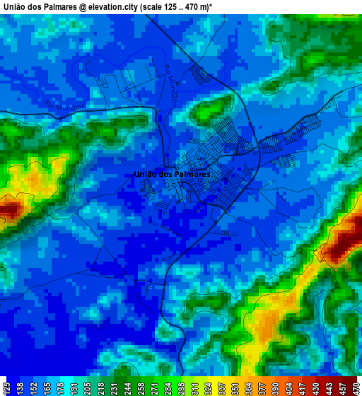
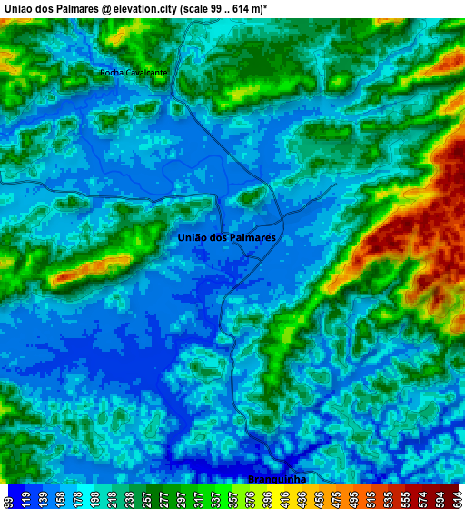
Below is the Elevation map of União dos Palmares, which displays elevation range with different colors. Scale of the first map is from 125 to 470 m (410 to 1542 ft) with average elevation of 183.7 meters (=603 ft) [note 1]
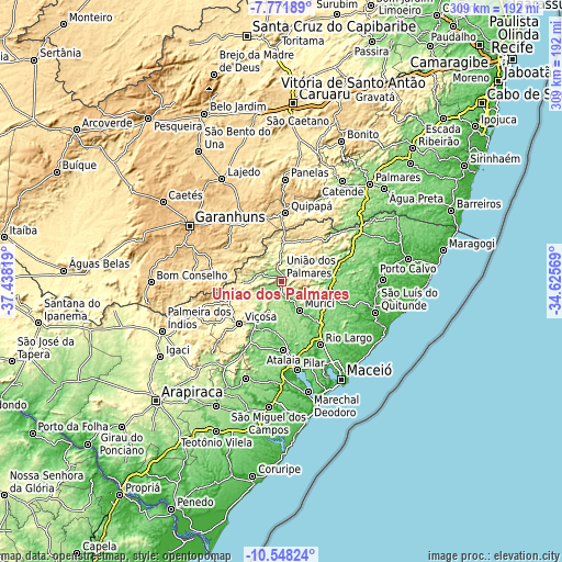
These maps also provides idea of topography and contour of this city, they are displayed at different zoom levels. More info about maps, scale and edge coordinates you can find below images.
| \ | Map #1 | Map #2 | Topo.Map |
| Scale [m] | 125..470 m | 99..614 m | × |
| Scale [ft] | 410..1542 ft | 325..2014 ft | × |
| Average | 183.7 m = 603 ft | 222.4 m = 730 ft | × |
| Width | 9.65 km = 6 mi | 19.3 km = 12 mi | 308.7 km = 191.8 mi |
| Height | 9.65 km = 6 mi | 19.3 km = 12 mi | 308.7 km = 191.8 mi |
| ↑Max Latitude | -9.119393° | -9.076° | -7.77189° |
| Latitude at center | -9.16278° | -9.16278° | -9.16278° |
| ↓Min Latitude | -9.206162° | -9.249539° | -10.54824° |
| ← Min Longitude | -36.075885° | -36.119831° | -37.43819° |
| Longitude center | -36.03194° | -36.03194° | -36.03194° |
| →Max Longitude | -35.987995° | -35.944049° | -34.62569° |
Nearby cities:
Cities around União dos Palmares sort by population:
• Rio Largo elevation 97 m
40.2 km,  150°
150°
• Murici 98 m
18.7 km, 148°
• Viçosa 227 m
32.6 km,  224°
224°
• Atalaia 61 m
37.7 km,  178°
178°
• São José da Laje 265 m
17.3 km,  350°
350°
• Capela 87 m
27.6 km,  189°
189°
• Messias 127 m
32.2 km,  139°
139°
• Canhotinho 529 m
35.8 km,  330°
330°
• Quipapá 458 m
37.3 km,  3°
3°
• Ibateguara 440 m
23.5 km,  25°
25°
• Flexeiras 132 m
27.8 km,  97°
97°
• Santana do Mundaú 229 m
20.9 km,  268°
268°
Multilingual:
 En español:
União dos Palmares elevación 154 m.
 En France:
União dos Palmares élévation 154 m.
 Auf Deutsch:
União dos Palmares höhe über dem Meeresspiegel ist 154 m.
 На русском:
União dos Palmares высота над уровнем моря 154 м
Sources and notes:
- [note 1] Map square and city borders are not equal. Map elevation data is calculated only from area inside that square.
- [src 1] Elevation data from geonames database provided with same terms of usage.
- [src 2] The elevation map of União dos Palmares is generated using elevation data from NASA's 3 arcsec (90m) resolution SRTM data.
- [src 3] Base (background) map © OpenStreetMap contributors tiles are generated by Geofabrik and OpenTopoMap.
Copyright & License:
This União dos Palmares Elevation Map is licensed under CC BY-SA. You may reuse any part from this page, if you give a proper credit by linking to this URL:
 More info on terms of use page.