Atalaia elevation
Atalaia (Alagoas), Brazil elevation is 61 meters and Atalaia elevation in feet is 200 ft above sea level [src 1]. Atalaia is a populated place (feature code) with elevation that is 321 meters (1053 ft) smaller than average city elevation in Brazil.
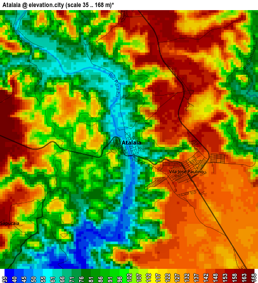
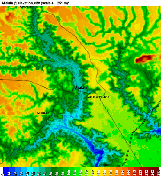
Below is the Elevation map of Atalaia, which displays elevation range with different colors. Scale of the first map is from 35 to 168 m (115 to 551 ft) with average elevation of 109.8 meters (=360 ft) [note 1]
These maps also provides idea of topography and contour of this city, they are displayed at different zoom levels. More info about maps, scale and edge coordinates you can find below images.
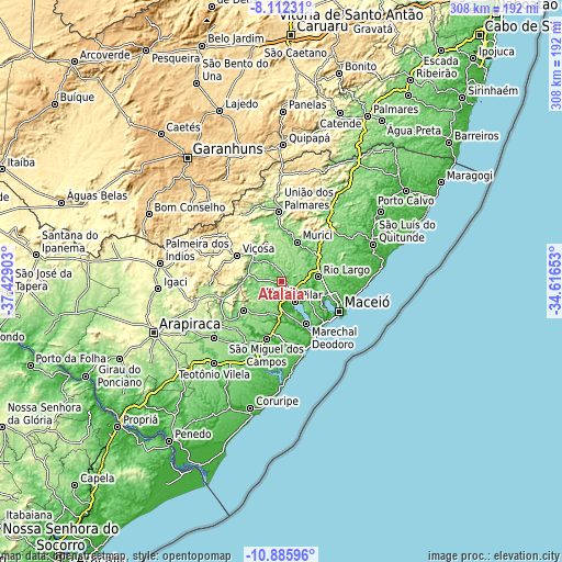
| \ | Map #1 | Map #2 | Topo.Map |
| Scale [m] | 35..168 m | 4..251 m | × |
| Scale [ft] | 115..551 ft | 13..823 ft | × |
| Average | 109.8 m = 360 ft | 121.2 m = 398 ft | × |
| Width | 9.64 km = 6 mi | 19.28 km = 12 mi | 308.4 km = 191.6 mi |
| Height | 9.64 km = 6 mi | 19.28 km = 12 mi | 308.4 km = 191.6 mi |
| ↑Max Latitude | -9.458595° | -9.415244° | -8.11231° |
| Latitude at center | -9.50194° | -9.50194° | -9.50194° |
| ↓Min Latitude | -9.54528° | -9.588614° | -10.88596° |
| ← Min Longitude | -36.066725° | -36.110671° | -37.42903° |
| Longitude center | -36.02278° | -36.02278° | -36.02278° |
| →Max Longitude | -35.978835° | -35.934889° | -34.61653° |
Nearby cities:
Cities around Atalaia sort by population:
• Maceió elevation 11 m
36.4 km,  120°
120°
• Rio Largo 97 m
18.8 km,  81°
81°
• Marechal Deodoro 12 m
27.1 km,  148°
148°
• São Miguel dos Campos 13 m
32 km,  194°
194°
• Pilar 125 m
12.8 km, 145°
• Murici 98 m
23.4 km,  21°
21°
• Viçosa 227 m
28 km,  301°
301°
• Satuba 48 m
22.8 km,  107°
107°
• Capela 87 m
11.9 km,  332°
332°
• Messias 127 m
23.8 km,  56°
56°
• Maribondo 160 m
32.1 km,  254°
254°
• Anadia 147 m
36.9 km,  236°
236°
Multilingual:
 En español:
Atalaia elevación 61 m.
 En France:
Atalaia élévation 61 m.


Sources and notes:
- [note 1] Map square and city borders are not equal. Map elevation data is calculated only from area inside that square.
- [src 1] Elevation data from geonames database provided with same terms of usage.
- [src 2] The elevation map of Atalaia is generated using elevation data from NASA's 3 arcsec (90m) resolution SRTM data.
- [src 3] Base (background) map © OpenStreetMap contributors tiles are generated by Geofabrik and OpenTopoMap.
Copyright & License:
This Atalaia Elevation Map is licensed under CC BY-SA. You may reuse any part from this page, if you give a proper credit by linking to this URL:
 More info on terms of use page.