Anadia elevation
Anadia (Alagoas), Brazil elevation is 147 meters and Anadia elevation in feet is 482 ft above sea level [src 1]. Anadia is a populated place (feature code) with elevation that is 235 meters (771 ft) smaller than average city elevation in Brazil.
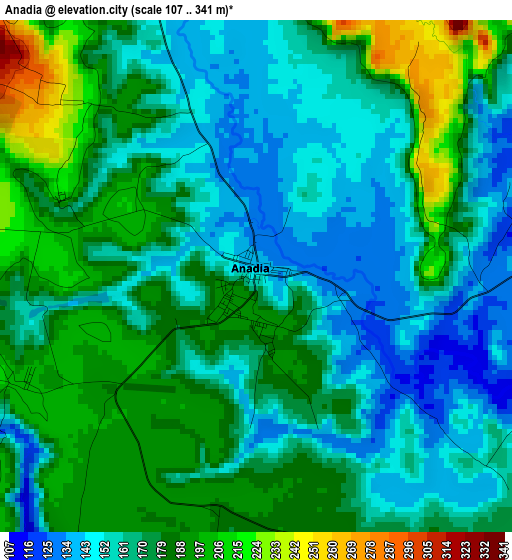
Below is the Elevation map of Anadia, which displays elevation range with different colors. Scale of the first map is from 107 to 341 m (351 to 1119 ft) with average elevation of 171.2 meters (=562 ft) [note 1]
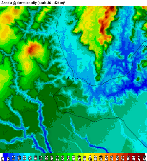
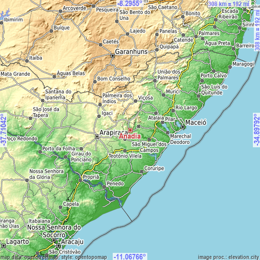
These maps also provides idea of topography and contour of this city, they are displayed at different zoom levels. More info about maps, scale and edge coordinates you can find below images.
| \ | Map #1 | Map #2 | Topo.Map |
| Scale [m] | 107..341 m | 86..424 m | × |
| Scale [ft] | 351..1119 ft | 282..1391 ft | × |
| Average | 171.2 m = 562 ft | 182.7 m = 599 ft | × |
| Width | 9.63 km = 6 mi | 19.27 km = 12 mi | 308.2 km = 191.5 mi |
| Height | 9.63 km = 6 mi | 19.27 km = 12 mi | 308.3 km = 191.6 mi |
| ↑Max Latitude | -9.641118° | -9.597791° | -8.2955° |
| Latitude at center | -9.68444° | -9.68444° | -9.68444° |
| ↓Min Latitude | -9.727756° | -9.771067° | -11.06766° |
| ← Min Longitude | -36.348115° | -36.392061° | -37.71042° |
| Longitude center | -36.30417° | -36.30417° | -36.30417° |
| →Max Longitude | -36.260225° | -36.216279° | -34.89792° |
Nearby cities:
Cities around Anadia sort by population:
• São Miguel dos Campos elevation 13 m
25.5 km,  114°
114°
• Pilar 125 m
39.3 km,  75°
75°
• Viçosa 227 m
35.5 km,  11°
11°
• Atalaia 61 m
36.9 km,  56°
56°
• Campo Alegre 181 m
12 km,  205°
205°
• Cajueiro 215 m
16.4 km,  257°
257°
• Maribondo 160 m
11.9 km,  359°
359°
• São Sebastião 204 m
39 km,  224°
224°
• Junqueiro 186 m
32.7 km, 215°
• Taquarana 242 m
21.6 km,  281°
281°
• Limoeiro de Anadia 125 m
22.6 km,  254°
254°
• Coité do Nóia 288 m
30.6 km, 280°
Multilingual:
 En español:
Anadia elevación 147 m.
 En France:
Anadia élévation 147 m.


Sources and notes:
- [note 1] Map square and city borders are not equal. Map elevation data is calculated only from area inside that square.
- [src 1] Elevation data from geonames database provided with same terms of usage.
- [src 2] The elevation map of Anadia is generated using elevation data from NASA's 3 arcsec (90m) resolution SRTM data.
- [src 3] Base (background) map © OpenStreetMap contributors tiles are generated by Geofabrik and OpenTopoMap.
Copyright & License:
This Anadia Elevation Map is licensed under CC BY-SA. You may reuse any part from this page, if you give a proper credit by linking to this URL:
 More info on terms of use page.