Gameleira elevation
Gameleira (Pernambuco), Brazil elevation is 100 meters and Gameleira elevation in feet is 328 ft above sea level [src 1]. Gameleira is a populated place (feature code) with elevation that is 282 meters (925 ft) smaller than average city elevation in Brazil.
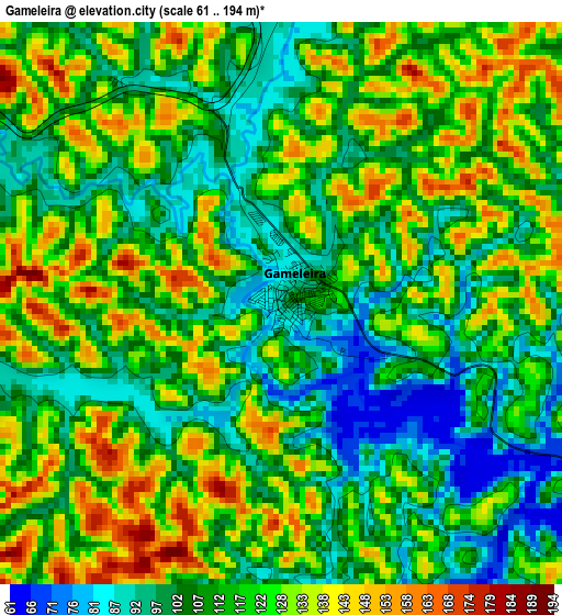
Below is the Elevation map of Gameleira, which displays elevation range with different colors. Scale of the first map is from 61 to 194 m (200 to 636 ft) with average elevation of 115.4 meters (=379 ft) [note 1]
These maps also provides idea of topography and contour of this city, they are displayed at different zoom levels. More info about maps, scale and edge coordinates you can find below images.
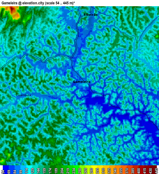
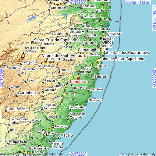
| \ | Map #1 | Map #2 | Topo.Map |
| Scale [m] | 61..194 m | 54..445 m | × |
| Scale [ft] | 200..636 ft | 177..1460 ft | × |
| Average | 115.4 m = 379 ft | 127.9 m = 420 ft | × |
| Width | 9.66 km = 6 mi | 19.33 km = 12 mi | 309.2 km = 192.1 mi |
| Height | 9.66 km = 6 mi | 19.33 km = 12 mi | 309.2 km = 192.1 mi |
| ↑Max Latitude | -8.540985° | -8.497524° | -7.19153° |
| Latitude at center | -8.58444° | -8.58444° | -8.58444° |
| ↓Min Latitude | -8.62789° | -8.671336° | -9.97226° |
| ← Min Longitude | -35.430615° | -35.474561° | -36.79292° |
| Longitude center | -35.38667° | -35.38667° | -35.38667° |
| →Max Longitude | -35.342725° | -35.298779° | -33.98042° |
Nearby cities:
Cities around Gameleira sort by population:
• Escada elevation 117 m
30.8 km,  35°
35°
• Palmares 115 m
25.1 km,  243°
243°
• Sirinhaém 43 m
29.8 km,  91°
91°
• Barreiros 28 m
34.1 km,  139°
139°
• Ribeirão 128 m
7.8 km,  7°
7°
• Catende 172 m
37.4 km,  255°
255°
• Tamandaré 12 m
36.9 km,  121°
121°
• Amaraji 262 m
23.5 km,  342°
342°
• Água Preta 133 m
20.9 km,  229°
229°
• Rio Formoso 87 m
26.3 km,  110°
110°
• Joaquim Nabuco 151 m
16.7 km,  254°
254°
• Guabiraba 481 m
36 km,  301°
301°
Multilingual:
 En español:
Gameleira elevación 100 m.
 En France:
Gameleira élévation 100 m.
 Auf Deutsch:
Gameleira höhe über dem Meeresspiegel ist 100 m.

Sources and notes:
- [note 1] Map square and city borders are not equal. Map elevation data is calculated only from area inside that square.
- [src 1] Elevation data from geonames database provided with same terms of usage.
- [src 2] The elevation map of Gameleira is generated using elevation data from NASA's 3 arcsec (90m) resolution SRTM data.
- [src 3] Base (background) map © OpenStreetMap contributors tiles are generated by Geofabrik and OpenTopoMap.
Copyright & License:
This Gameleira Elevation Map is licensed under CC BY-SA. You may reuse any part from this page, if you give a proper credit by linking to this URL:
 More info on terms of use page.