Rio Formoso elevation
Rio Formoso (Pernambuco), Brazil elevation is 87 meters and Rio Formoso elevation in feet is 285 ft above sea level [src 1]. Rio Formoso is a seat of a second-order administrative division (feature code) with elevation that is 295 meters (968 ft) smaller than average city elevation in Brazil.
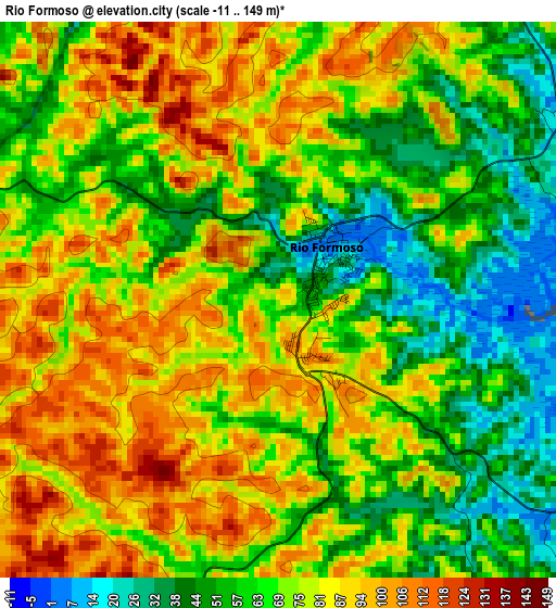
Below is the Elevation map of Rio Formoso, which displays elevation range with different colors. Scale of the first map is from -11 to 149 m (-36 to 489 ft) with average elevation of 71.9 meters (=236 ft) [note 1]
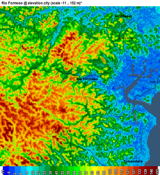
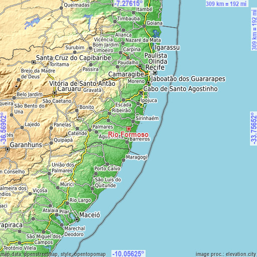
These maps also provides idea of topography and contour of this city, they are displayed at different zoom levels. More info about maps, scale and edge coordinates you can find below images.
| \ | Map #1 | Map #2 | Topo.Map |
| Scale [m] | -11..149 m | -11..152 m | × |
| Scale [ft] | -36..489 ft | -36..499 ft | × |
| Average | 71.9 m = 236 ft | 60.1 m = 197 ft | × |
| Width | 9.66 km = 6 mi | 19.32 km = 12 mi | 309.1 km = 192.1 mi |
| Height | 9.66 km = 6 mi | 19.32 km = 12 mi | 309.1 km = 192.1 mi |
| ↑Max Latitude | -8.625324° | -8.581873° | -7.27615° |
| Latitude at center | -8.66877° | -8.66877° | -8.66877° |
| ↓Min Latitude | -8.712211° | -8.755647° | -10.05625° |
| ← Min Longitude | -35.206715° | -35.250661° | -36.56902° |
| Longitude center | -35.16277° | -35.16277° | -35.16277° |
| →Max Longitude | -35.118825° | -35.074879° | -33.75652° |
Nearby cities:
Cities around Rio Formoso sort by population:
• Ipojuca elevation 29 m
31.9 km,  19°
19°
• Escada 117 m
35.1 km,  349°
349°
• Sirinhaém 43 m
10.1 km,  30°
30°
• Barreiros 28 m
16.8 km,  188°
188°
• Ribeirão 128 m
29.2 km,  305°
305°
• Gameleira 100 m
26.3 km,  290°
290°
• Tamandaré 12 m
11.9 km,  144°
144°
• Amaraji 262 m
45 km, 314°
• Água Preta 133 m
40.7 km,  263°
263°
• Maragogi 16 m
38.7 km, 189°
• São José da Coroa Grande 9 m
25.5 km,  176°
176°
• Joaquim Nabuco 151 m
41 km,  276°
276°
Multilingual:
 En español:
Rio Formoso elevación 87 m.
 En France:
Rio Formoso élévation 87 m.
 Auf Deutsch:
Rio Formoso höhe über dem Meeresspiegel ist 87 m.

Sources and notes:
- [note 1] Map square and city borders are not equal. Map elevation data is calculated only from area inside that square.
- [src 1] Elevation data from geonames database provided with same terms of usage.
- [src 2] The elevation map of Rio Formoso is generated using elevation data from NASA's 3 arcsec (90m) resolution SRTM data.
- [src 3] Base (background) map © OpenStreetMap contributors tiles are generated by Geofabrik and OpenTopoMap.
Copyright & License:
This Rio Formoso Elevation Map is licensed under CC BY-SA. You may reuse any part from this page, if you give a proper credit by linking to this URL:
 More info on terms of use page.