Ipojuca elevation
Ipojuca (Pernambuco), Brazil elevation is 29 meters and Ipojuca elevation in feet is 95 ft above sea level [src 1]. Ipojuca is a populated place (feature code) with elevation that is 353 meters (1158 ft) smaller than average city elevation in Brazil.
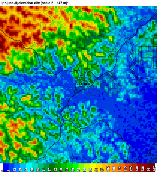
Below is the Elevation map of Ipojuca, which displays elevation range with different colors. Scale of the first map is from 2 to 147 m (7 to 482 ft) with average elevation of 42.5 meters (=139 ft) [note 1]
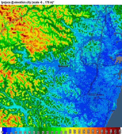
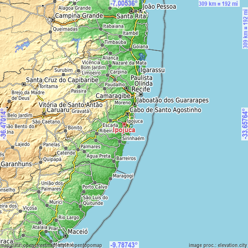
These maps also provides idea of topography and contour of this city, they are displayed at different zoom levels. More info about maps, scale and edge coordinates you can find below images.
| \ | Map #1 | Map #2 | Topo.Map |
| Scale [m] | 2..147 m | -6..178 m | × |
| Scale [ft] | 7..482 ft | -20..584 ft | × |
| Average | 42.5 m = 139 ft | 50.5 m = 166 ft | × |
| Width | 9.67 km = 6 mi | 19.34 km = 12 mi | 309.3 km = 192.2 mi |
| Height | 9.67 km = 6 mi | 19.34 km = 12 mi | 309.4 km = 192.3 mi |
| ↑Max Latitude | -8.355414° | -8.311932° | -7.00536° |
| Latitude at center | -8.39889° | -8.39889° | -8.39889° |
| ↓Min Latitude | -8.442362° | -8.485828° | -9.78743° |
| ← Min Longitude | -35.107835° | -35.151781° | -36.47014° |
| Longitude center | -35.06389° | -35.06389° | -35.06389° |
| →Max Longitude | -35.019945° | -34.975999° | -33.65764° |
Nearby cities:
Cities around Ipojuca sort by population:
• Jaboatão elevation 88 m
25.3 km,  15°
15°
• Jaboatão dos Guararapes 48 m
32.3 km,  9°
9°
• Cabo 16 m
13.3 km, 14°
• Vitória de Santo Antão 156 m
40 km,  321°
321°
• Escada 117 m
18.1 km,  284°
284°
• Moreno 78 m
31.3 km,  354°
354°
• Sirinhaém 43 m
22.1 km,  195°
195°
• Ribeirão 128 m
36.8 km,  249°
249°
• Gameleira 100 m
41.1 km,  239°
239°
• Tamandaré 12 m
39.9 km,  185°
185°
• Amaraji 262 m
42.8 km,  272°
272°
• Rio Formoso 87 m
31.9 km, 199°
Multilingual:
 En español:
Ipojuca elevación 29 m.
 En France:
Ipojuca élévation 29 m.


Sources and notes:
- [note 1] Map square and city borders are not equal. Map elevation data is calculated only from area inside that square.
- [src 1] Elevation data from geonames database provided with same terms of usage.
- [src 2] The elevation map of Ipojuca is generated using elevation data from NASA's 3 arcsec (90m) resolution SRTM data.
- [src 3] Base (background) map © OpenStreetMap contributors tiles are generated by Geofabrik and OpenTopoMap.
Copyright & License:
This Ipojuca Elevation Map is licensed under CC BY-SA. You may reuse any part from this page, if you give a proper credit by linking to this URL:
 More info on terms of use page.