Boa Viagem elevation
Boa Viagem (Ceará), Brazil elevation is 288 meters and Boa Viagem elevation in feet is 945 ft above sea level [src 1]. Boa Viagem is a populated place (feature code) with elevation that is 94 meters (308 ft) smaller than average city elevation in Brazil.
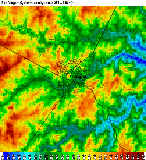
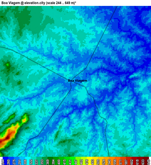
Below is the Elevation map of Boa Viagem, which displays elevation range with different colors. Scale of the first map is from 253 to 338 m (830 to 1109 ft) with average elevation of 295.8 meters (=970 ft) [note 1]
These maps also provides idea of topography and contour of this city, they are displayed at different zoom levels. More info about maps, scale and edge coordinates you can find below images.
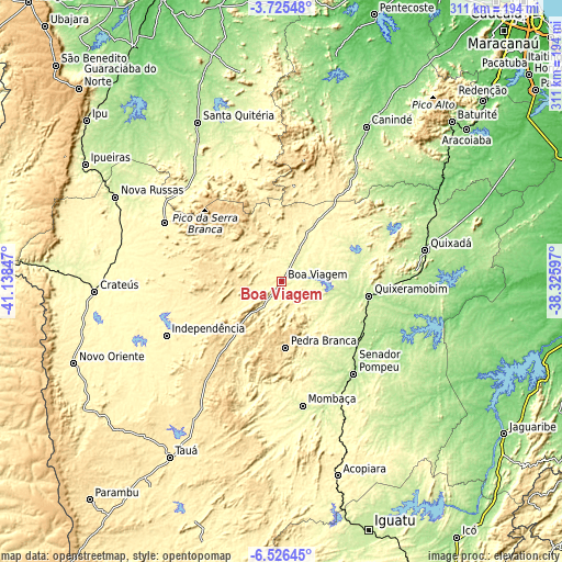
| \ | Map #1 | Map #2 | Topo.Map |
| Scale [m] | 253..338 m | 244..649 m | × |
| Scale [ft] | 830..1109 ft | 801..2129 ft | × |
| Average | 295.8 m = 970 ft | 309.6 m = 1016 ft | × |
| Width | 9.73 km = 6 mi | 19.47 km = 12.1 mi | 311.4 km = 193.5 mi |
| Height | 9.73 km = 6 mi | 19.47 km = 12.1 mi | 311.5 km = 193.6 mi |
| ↑Max Latitude | -5.083729° | -5.039955° | -3.72548° |
| Latitude at center | -5.1275° | -5.1275° | -5.1275° |
| ↓Min Latitude | -5.171268° | -5.215033° | -6.52645° |
| ← Min Longitude | -39.776165° | -39.820111° | -41.13847° |
| Longitude center | -39.73222° | -39.73222° | -39.73222° |
| →Max Longitude | -39.688275° | -39.644329° | -38.32597° |
Nearby cities:
Cities around Boa Viagem sort by population:
• Crateús elevation 297 m
104.8 km,  266°
266°
• Quixadá 186 m
81.3 km,  77°
77°
• Canindé 154 m
97.3 km,  28°
28°
• Quixeramobim 202 m
49.3 km,  99°
99°
• Santa Quitéria 198 m
100.2 km,  332°
332°
• Nova Russas 239 m
103.3 km,  296°
296°
• Várzea Alegre 320 m
76.2 km,  251°
251°
• Pedra Branca 506 m
36.4 km,  177°
177°
• Mombaça 251 m
69.4 km,  170°
170°
• Senador Pompeu 181 m
64.9 km,  142°
142°
• Tamboril 321 m
73 km, 296°
• Independência 341 m
70.5 km,  244°
244°
Multilingual:
 En español:
Boa Viagem elevación 288 m.
 En France:
Boa Viagem élévation 288 m.
 Auf Deutsch:
Boa Viagem höhe über dem Meeresspiegel ist 288 m.

Sources and notes:
- [note 1] Map square and city borders are not equal. Map elevation data is calculated only from area inside that square.
- [src 1] Elevation data from geonames database provided with same terms of usage.
- [src 2] The elevation map of Boa Viagem is generated using elevation data from NASA's 3 arcsec (90m) resolution SRTM data.
- [src 3] Base (background) map © OpenStreetMap contributors tiles are generated by Geofabrik and OpenTopoMap.
Copyright & License:
This Boa Viagem Elevation Map is licensed under CC BY-SA. You may reuse any part from this page, if you give a proper credit by linking to this URL:
 More info on terms of use page.