Várzea Alegre elevation
Várzea Alegre (Ceará, Independência), Brazil elevation is 320 meters and Várzea Alegre elevation in feet is 1050 ft above sea level [src 1]. Várzea Alegre is a populated place (feature code) with elevation that is 62 meters (203 ft) smaller than average city elevation in Brazil.
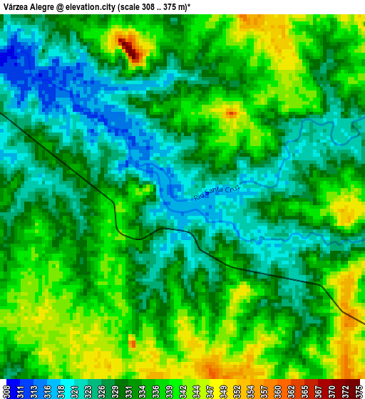
Below is the Elevation map of Várzea Alegre, which displays elevation range with different colors. Scale of the first map is from 308 to 375 m (1010 to 1230 ft) with average elevation of 332.7 meters (=1092 ft) [note 1]
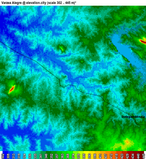
These maps also provides idea of topography and contour of this city, they are displayed at different zoom levels. More info about maps, scale and edge coordinates you can find below images.
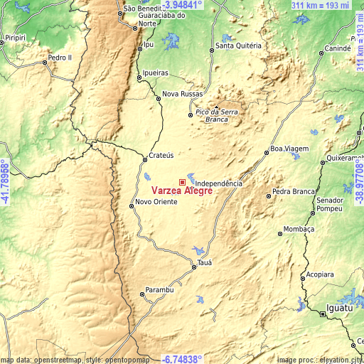
| \ | Map #1 | Map #2 | Topo.Map |
| Scale [m] | 308..375 m | 302..445 m | × |
| Scale [ft] | 1010..1230 ft | 991..1460 ft | × |
| Average | 332.7 m = 1092 ft | 334.8 m = 1098 ft | × |
| Width | 9.73 km = 6 mi | 19.46 km = 12.1 mi | 311.3 km = 193.4 mi |
| Height | 9.73 km = 6 mi | 19.46 km = 12.1 mi | 311.4 km = 193.5 mi |
| ↑Max Latitude | -5.306245° | -5.262486° | -3.94841° |
| Latitude at center | -5.35° | -5.35° | -5.35° |
| ↓Min Latitude | -5.393752° | -5.437501° | -6.74838° |
| ← Min Longitude | -40.427275° | -40.471221° | -41.78958° |
| Longitude center | -40.38333° | -40.38333° | -40.38333° |
| →Max Longitude | -40.339385° | -40.295439° | -38.97708° |
Nearby cities:
Cities around Várzea Alegre sort by population:
• Crateús elevation 297 m
37.8 km,  300°
300°
• São João dos Inhamuns 405 m
73.1 km,  171°
171°
• Boa Viagem 288 m
76.2 km,  71°
71°
• Nova Russas 239 m
74.2 km,  344°
344°
• Pedra Branca 506 m
74.6 km,  98°
98°
• Mombaça 251 m
94.4 km,  117°
117°
• Parambu 478 m
101.7 km,  199°
199°
• Novo Oriente 347 m
47.9 km,  244°
244°
• Tamboril 321 m
58 km,  6°
6°
• Independência 341 m
9.7 km, 121°
• Hidrolândia 179 m
104.9 km,  356°
356°
• São Miguel do Tapuio 283 m
105.4 km,  260°
260°
Multilingual:
 En español:
Várzea Alegre elevación 320 m.
 En France:
Várzea Alegre élévation 320 m.
 Auf Deutsch:
Várzea Alegre höhe über dem Meeresspiegel ist 320 m.

Sources and notes:
- [note 1] Map square and city borders are not equal. Map elevation data is calculated only from area inside that square.
- [src 1] Elevation data from geonames database provided with same terms of usage.
- [src 2] The elevation map of Várzea Alegre is generated using elevation data from NASA's 3 arcsec (90m) resolution SRTM data.
- [src 3] Base (background) map © OpenStreetMap contributors tiles are generated by Geofabrik and OpenTopoMap.
Copyright & License:
This Várzea Alegre Elevation Map is licensed under CC BY-SA. You may reuse any part from this page, if you give a proper credit by linking to this URL:
 More info on terms of use page.