Tamboril elevation
Tamboril (Ceará), Brazil elevation is 321 meters and Tamboril elevation in feet is 1053 ft above sea level [src 1]. Tamboril is a populated place (feature code) with elevation that is 61 meters (200 ft) smaller than average city elevation in Brazil.
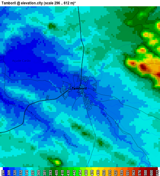
Below is the Elevation map of Tamboril, which displays elevation range with different colors. Scale of the first map is from 296 to 612 m (971 to 2008 ft) with average elevation of 351 meters (=1152 ft) [note 1]
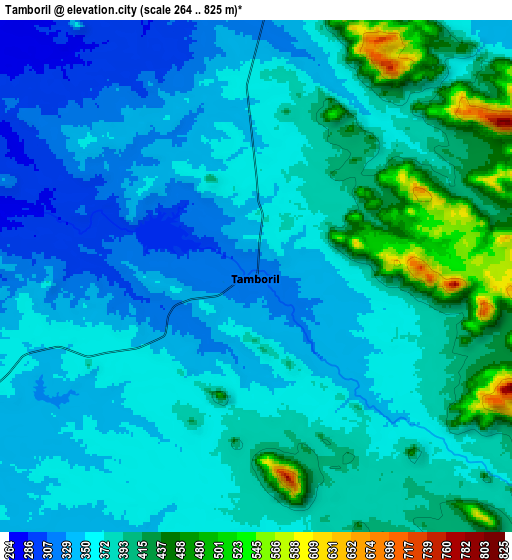
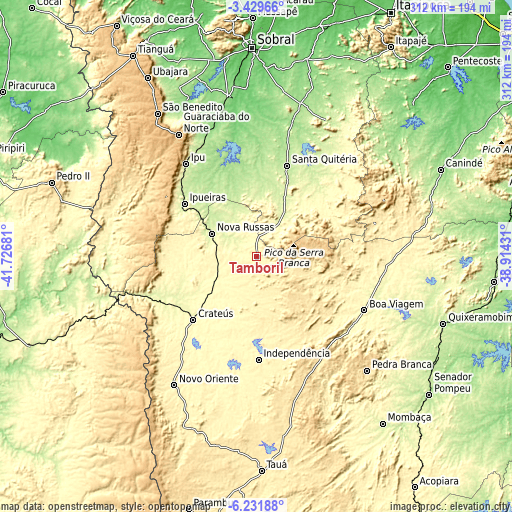
These maps also provides idea of topography and contour of this city, they are displayed at different zoom levels. More info about maps, scale and edge coordinates you can find below images.
| \ | Map #1 | Map #2 | Topo.Map |
| Scale [m] | 296..612 m | 264..825 m | × |
| Scale [ft] | 971..2008 ft | 866..2707 ft | × |
| Average | 351 m = 1152 ft | 375.1 m = 1231 ft | × |
| Width | 9.74 km = 6.1 mi | 19.48 km = 12.1 mi | 311.6 km = 193.6 mi |
| Height | 9.74 km = 6.1 mi | 19.48 km = 12.1 mi | 311.6 km = 193.6 mi |
| ↑Max Latitude | -4.788429° | -4.744636° | -3.42966° |
| Latitude at center | -4.83222° | -4.83222° | -4.83222° |
| ↓Min Latitude | -4.876008° | -4.919793° | -6.23188° |
| ← Min Longitude | -40.364505° | -40.408451° | -41.72681° |
| Longitude center | -40.32056° | -40.32056° | -40.32056° |
| →Max Longitude | -40.276615° | -40.232669° | -38.91431° |
Nearby cities:
Cities around Tamboril sort by population:
• Crateús elevation 297 m
55.2 km,  225°
225°
• Ipu 250 m
71.3 km,  322°
322°
• Boa Viagem 288 m
73 km,  116°
116°
• Santa Quitéria 198 m
58.5 km,  18°
18°
• Nova Russas 239 m
30.3 km,  297°
297°
• Várzea Alegre 320 m
58 km,  186°
186°
• Guaraciaba do Norte 902 m
87.8 km,  327°
327°
• Varjota 187 m
73 km,  346°
346°
• Novo Oriente 347 m
92.8 km,  212°
212°
• Reriutaba 153 m
82.1 km,  339°
339°
• Independência 341 m
62.7 km,  178°
178°
• Hidrolândia 179 m
48.9 km, 344°
Multilingual:
 En español:
Tamboril elevación 321 m.
 En France:
Tamboril élévation 321 m.
 Auf Deutsch:
Tamboril höhe über dem Meeresspiegel ist 321 m.

Sources and notes:
- [note 1] Map square and city borders are not equal. Map elevation data is calculated only from area inside that square.
- [src 1] Elevation data from geonames database provided with same terms of usage.
- [src 2] The elevation map of Tamboril is generated using elevation data from NASA's 3 arcsec (90m) resolution SRTM data.
- [src 3] Base (background) map © OpenStreetMap contributors tiles are generated by Geofabrik and OpenTopoMap.
Copyright & License:
This Tamboril Elevation Map is licensed under CC BY-SA. You may reuse any part from this page, if you give a proper credit by linking to this URL:
 More info on terms of use page.