Santa Quitéria elevation
Santa Quitéria (Ceará), Brazil elevation is 198 meters and Santa Quitéria elevation in feet is 650 ft above sea level [src 1]. Santa Quitéria is a populated place (feature code) with elevation that is 184 meters (604 ft) smaller than average city elevation in Brazil.
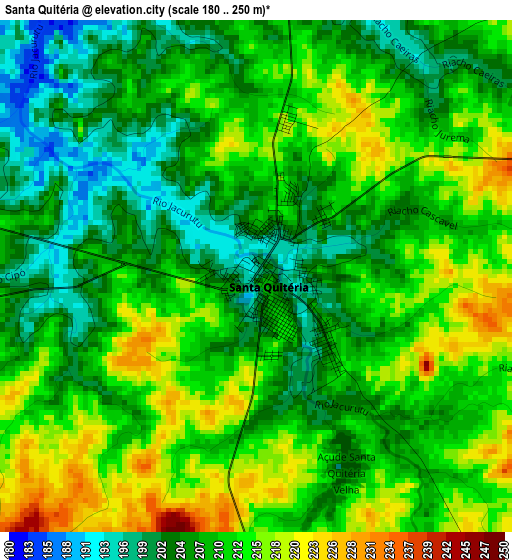
Below is the Elevation map of Santa Quitéria, which displays elevation range with different colors. Scale of the first map is from 180 to 250 m (591 to 820 ft) with average elevation of 209.5 meters (=687 ft) [note 1]
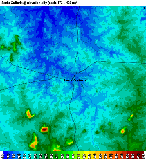
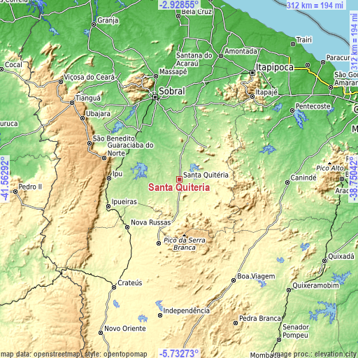
These maps also provides idea of topography and contour of this city, they are displayed at different zoom levels. More info about maps, scale and edge coordinates you can find below images.
| \ | Map #1 | Map #2 | Topo.Map |
| Scale [m] | 180..250 m | 173..429 m | × |
| Scale [ft] | 591..820 ft | 568..1407 ft | × |
| Average | 209.5 m = 687 ft | 220.6 m = 724 ft | × |
| Width | 9.74 km = 6.1 mi | 19.49 km = 12.1 mi | 311.8 km = 193.7 mi |
| Height | 9.74 km = 6.1 mi | 19.49 km = 12.1 mi | 311.8 km = 193.7 mi |
| ↑Max Latitude | -4.288119° | -4.244295° | -2.92855° |
| Latitude at center | -4.33194° | -4.33194° | -4.33194° |
| ↓Min Latitude | -4.375758° | -4.419574° | -5.73273° |
| ← Min Longitude | -40.200615° | -40.244561° | -41.56292° |
| Longitude center | -40.15667° | -40.15667° | -40.15667° |
| →Max Longitude | -40.112725° | -40.068779° | -38.75042° |
Nearby cities:
Cities around Santa Quitéria sort by population:
• Sobral elevation 75 m
74.9 km,  343°
343°
• Ipu 250 m
61.5 km,  271°
271°
• Nova Russas 239 m
61.4 km,  227°
227°
• Guaraciaba do Norte 902 m
68 km,  285°
285°
• Varjota 187 m
38.6 km, 293°
• Tamboril 321 m
58.5 km,  198°
198°
• Forquilha 92 m
60.4 km,  349°
349°
• Irauçuba 150 m
77.2 km,  32°
32°
• Reriutaba 153 m
51.7 km, 294°
• Hidrolândia 179 m
32.3 km,  254°
254°
• Ibiapina 897 m
93.1 km,  299°
299°
• Cariré 162 m
55.1 km,  320°
320°
Multilingual:
 En español:
Santa Quitéria elevación 198 m.
 En France:
Santa Quitéria élévation 198 m.
 Auf Deutsch:
Santa Quitéria höhe über dem Meeresspiegel ist 198 m.

Sources and notes:
- [note 1] Map square and city borders are not equal. Map elevation data is calculated only from area inside that square.
- [src 1] Elevation data from geonames database provided with same terms of usage.
- [src 2] The elevation map of Santa Quitéria is generated using elevation data from NASA's 3 arcsec (90m) resolution SRTM data.
- [src 3] Base (background) map © OpenStreetMap contributors tiles are generated by Geofabrik and OpenTopoMap.
Copyright & License:
This Santa Quitéria Elevation Map is licensed under CC BY-SA. You may reuse any part from this page, if you give a proper credit by linking to this URL:
 More info on terms of use page.