São Miguel do Tapuio elevation
São Miguel do Tapuio (Piauí), Brazil elevation is 283 meters and São Miguel do Tapuio elevation in feet is 928 ft above sea level [src 1]. São Miguel do Tapuio is a populated place (feature code) with elevation that is 99 meters (325 ft) smaller than average city elevation in Brazil.
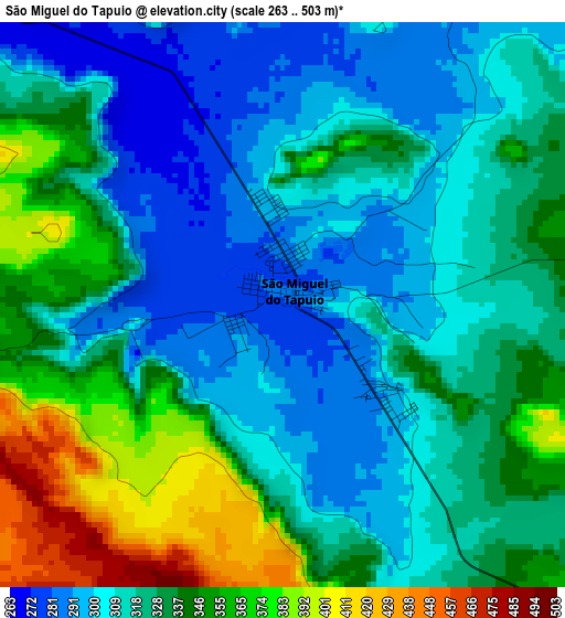
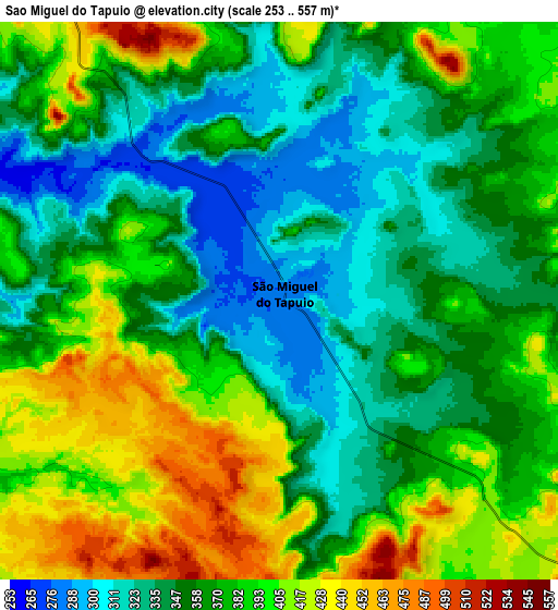
Below is the Elevation map of São Miguel do Tapuio, which displays elevation range with different colors. Scale of the first map is from 263 to 503 m (863 to 1650 ft) with average elevation of 326.6 meters (=1072 ft) [note 1]
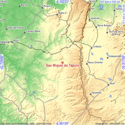
These maps also provides idea of topography and contour of this city, they are displayed at different zoom levels. More info about maps, scale and edge coordinates you can find below images.
| \ | Map #1 | Map #2 | Topo.Map |
| Scale [m] | 263..503 m | 253..557 m | × |
| Scale [ft] | 863..1650 ft | 830..1827 ft | × |
| Average | 326.6 m = 1072 ft | 369.5 m = 1212 ft | × |
| Width | 9.73 km = 6 mi | 19.46 km = 12.1 mi | 311.2 km = 193.4 mi |
| Height | 9.73 km = 6 mi | 19.45 km = 12.1 mi | 311.3 km = 193.4 mi |
| ↑Max Latitude | -5.459866° | -5.416118° | -4.10233° |
| Latitude at center | -5.50361° | -5.50361° | -5.50361° |
| ↓Min Latitude | -5.547351° | -5.591089° | -6.90159° |
| ← Min Longitude | -41.367275° | -41.411221° | -42.72958° |
| Longitude center | -41.32333° | -41.32333° | -41.32333° |
| →Max Longitude | -41.279385° | -41.235439° | -39.91708° |
Nearby cities:
Cities around São Miguel do Tapuio sort by population:
• Crateús elevation 297 m
80.1 km,  63°
63°
• Campo Maior 128 m
120 km,  308°
308°
• Várzea Alegre 320 m
105.4 km,  80°
80°
• Valença do Piauí 336 m
110.8 km,  204°
204°
• Parambu 478 m
105 km,  138°
138°
• Novo Oriente 347 m
60.9 km,  93°
93°
• Independência 341 m
112.9 km, 83°
• Elesbão Veloso 196 m
119.1 km,  229°
229°
• Castelo do Piauí 241 m
32.4 km, 308°
• Beneditinos 118 m
115.6 km,  272°
272°
• Alto Longá 141 m
102.1 km,  285°
285°
• Pimenteiras 280 m
83.1 km,  187°
187°
Multilingual:
 En español:
São Miguel do Tapuio elevación 283 m.
 En France:
São Miguel do Tapuio élévation 283 m.
 Auf Deutsch:
São Miguel do Tapuio höhe über dem Meeresspiegel ist 283 m.
 На русском:
Сан-Мигел-ду-Тапую высота над уровнем моря 283 м
Sources and notes:
- [note 1] Map square and city borders are not equal. Map elevation data is calculated only from area inside that square.
- [src 1] Elevation data from geonames database provided with same terms of usage.
- [src 2] The elevation map of São Miguel do Tapuio is generated using elevation data from NASA's 3 arcsec (90m) resolution SRTM data.
- [src 3] Base (background) map © OpenStreetMap contributors tiles are generated by Geofabrik and OpenTopoMap.
Copyright & License:
This São Miguel do Tapuio Elevation Map is licensed under CC BY-SA. You may reuse any part from this page, if you give a proper credit by linking to this URL:
 More info on terms of use page.