Orós elevation
Orós (Ceará), Brazil elevation is 193 meters and Orós elevation in feet is 633 ft above sea level [src 1]. Orós is a populated place (feature code) with elevation that is 189 meters (620 ft) smaller than average city elevation in Brazil.
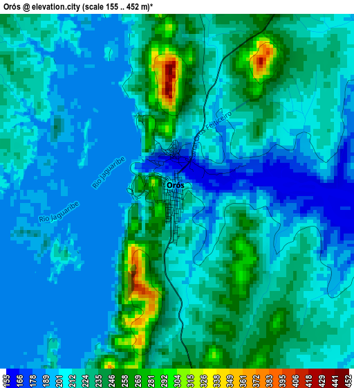
Below is the Elevation map of Orós, which displays elevation range with different colors. Scale of the first map is from 155 to 452 m (509 to 1483 ft) with average elevation of 217.4 meters (=713 ft) [note 1]
These maps also provides idea of topography and contour of this city, they are displayed at different zoom levels. More info about maps, scale and edge coordinates you can find below images.
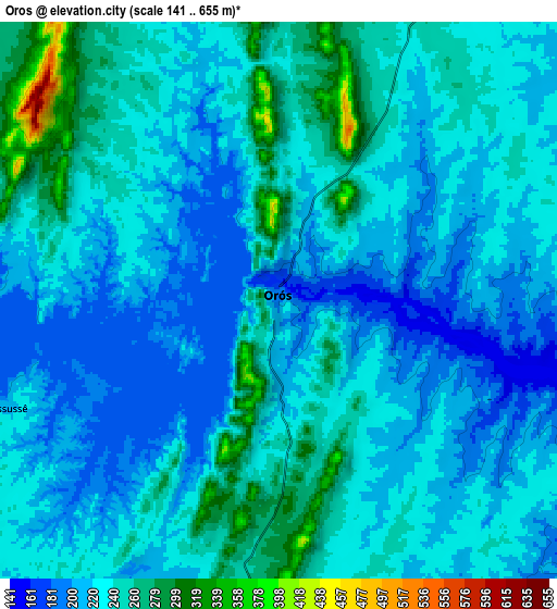
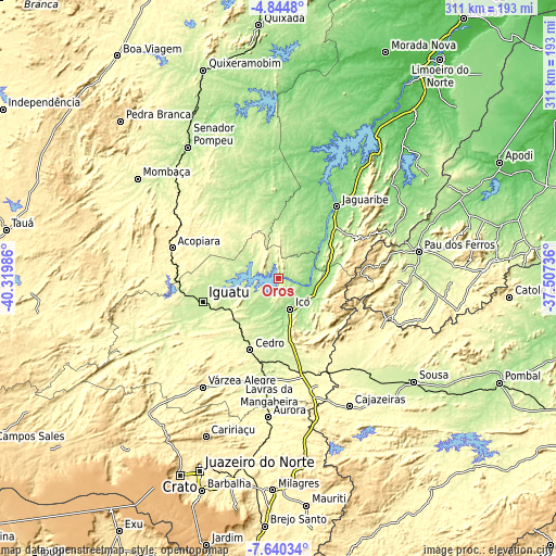
| \ | Map #1 | Map #2 | Topo.Map |
| Scale [m] | 155..452 m | 141..655 m | × |
| Scale [ft] | 509..1483 ft | 463..2149 ft | × |
| Average | 217.4 m = 713 ft | 231.9 m = 761 ft | × |
| Width | 9.71 km = 6 mi | 19.43 km = 12.1 mi | 310.8 km = 193.1 mi |
| Height | 9.71 km = 6 mi | 19.43 km = 12.1 mi | 310.9 km = 193.2 mi |
| ↑Max Latitude | -6.200754° | -6.157064° | -4.8448° |
| Latitude at center | -6.24444° | -6.24444° | -6.24444° |
| ↓Min Latitude | -6.288123° | -6.331802° | -7.64034° |
| ← Min Longitude | -38.957555° | -39.001501° | -40.31986° |
| Longitude center | -38.91361° | -38.91361° | -38.91361° |
| →Max Longitude | -38.869665° | -38.825719° | -37.50736° |
Nearby cities:
Cities around Orós sort by population:
• Iguatu elevation 222 m
44.4 km,  253°
253°
• Icó 156 m
18.3 km,  161°
161°
• Acopiara 319 m
61.8 km,  285°
285°
• Jaguaribe 127 m
50.9 km,  39°
39°
• Lavras da Mangabeira 241 m
56.9 km,  185°
185°
• Jucás 246 m
74.7 km, 245°
• Cedro 252 m
43.5 km,  202°
202°
• Barro 290 m
52.8 km,  174°
174°
• Aurora 273 m
77.8 km,  184°
184°
• Serra Branca 327 m
78.4 km,  114°
114°
• Uiraúna 298 m
63.2 km,  118°
118°
• Triunfo 340 m
49.8 km,  135°
135°
Multilingual:
 En español:
Orós elevación 193 m.
 En France:
Orós élévation 193 m.


Sources and notes:
- [note 1] Map square and city borders are not equal. Map elevation data is calculated only from area inside that square.
- [src 1] Elevation data from geonames database provided with same terms of usage.
- [src 2] The elevation map of Orós is generated using elevation data from NASA's 3 arcsec (90m) resolution SRTM data.
- [src 3] Base (background) map © OpenStreetMap contributors tiles are generated by Geofabrik and OpenTopoMap.
Copyright & License:
This Orós Elevation Map is licensed under CC BY-SA. You may reuse any part from this page, if you give a proper credit by linking to this URL:
 More info on terms of use page.