Barro elevation
Barro (Ceará, Lavras da Mangabeira), Brazil elevation is 290 meters and Barro elevation in feet is 951 ft above sea level [src 1]. Barro is a populated place (feature code) with elevation that is 92 meters (302 ft) smaller than average city elevation in Brazil.
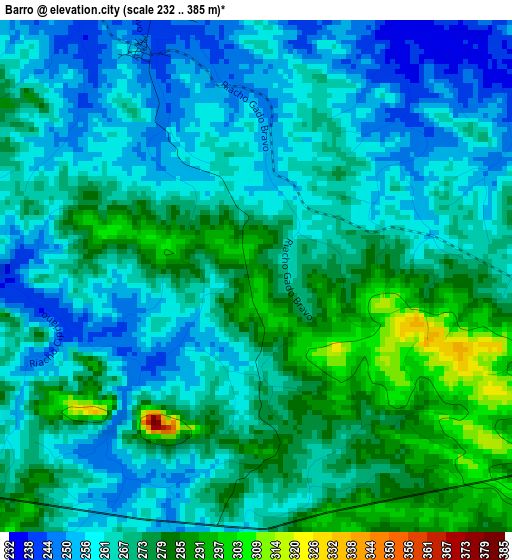
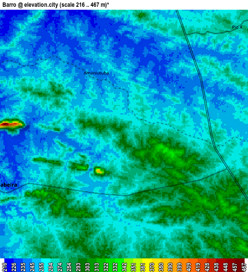
Below is the Elevation map of Barro, which displays elevation range with different colors. Scale of the first map is from 232 to 385 m (761 to 1263 ft) with average elevation of 268.1 meters (=880 ft) [note 1]
These maps also provides idea of topography and contour of this city, they are displayed at different zoom levels. More info about maps, scale and edge coordinates you can find below images.
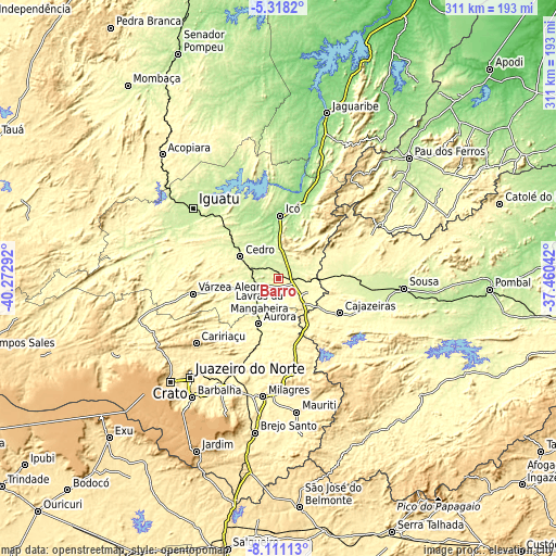
| \ | Map #1 | Map #2 | Topo.Map |
| Scale [m] | 232..385 m | 216..467 m | × |
| Scale [ft] | 761..1263 ft | 709..1532 ft | × |
| Average | 268.1 m = 880 ft | 263.9 m = 866 ft | × |
| Width | 9.71 km = 6 mi | 19.41 km = 12.1 mi | 310.5 km = 192.9 mi |
| Height | 9.71 km = 6 mi | 19.41 km = 12.1 mi | 310.6 km = 193 mi |
| ↑Max Latitude | -6.673024° | -6.629375° | -5.3182° |
| Latitude at center | -6.71667° | -6.71667° | -6.71667° |
| ↓Min Latitude | -6.760312° | -6.80395° | -8.11113° |
| ← Min Longitude | -38.910615° | -38.954561° | -40.27292° |
| Longitude center | -38.86667° | -38.86667° | -38.86667° |
| →Max Longitude | -38.822725° | -38.778779° | -37.46042° |
Nearby cities:
Cities around Barro sort by population:
• Iguatu elevation 222 m
62.1 km,  309°
309°
• Cajazeiras 305 m
39.4 km,  119°
119°
• Icó 156 m
35.1 km,  0°
0°
• Lavras da Mangabeira 241 m
11.5 km,  249°
249°
• Orós 193 m
52.8 km,  354°
354°
• Cedro 252 m
24.8 km,  299°
299°
• Missão Velha 364 m
66.7 km,  207°
207°
• Caririaçu 712 m
58.6 km,  231°
231°
• Aurora 273 m
27.5 km,  203°
203°
• Uiraúna 298 m
54.8 km,  66°
66°
• São José de Piranhas 344 m
60.3 km,  138°
138°
• Triunfo 340 m
33.8 km,  60°
60°
Multilingual:
 En español:
Barro elevación 290 m.
 En France:
Barro élévation 290 m.


Sources and notes:
- [note 1] Map square and city borders are not equal. Map elevation data is calculated only from area inside that square.
- [src 1] Elevation data from geonames database provided with same terms of usage.
- [src 2] The elevation map of Barro is generated using elevation data from NASA's 3 arcsec (90m) resolution SRTM data.
- [src 3] Base (background) map © OpenStreetMap contributors tiles are generated by Geofabrik and OpenTopoMap.
Copyright & License:
This Barro Elevation Map is licensed under CC BY-SA. You may reuse any part from this page, if you give a proper credit by linking to this URL:
 More info on terms of use page.