Jaguaribe elevation
Jaguaribe (Ceará), Brazil elevation is 127 meters and Jaguaribe elevation in feet is 417 ft above sea level [src 1]. Jaguaribe is a populated place (feature code) with elevation that is 255 meters (837 ft) smaller than average city elevation in Brazil.
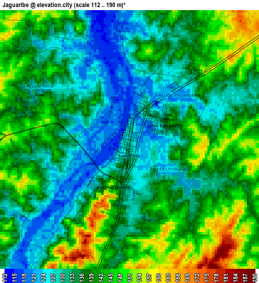
Below is the Elevation map of Jaguaribe, which displays elevation range with different colors. Scale of the first map is from 112 to 190 m (367 to 623 ft) with average elevation of 137.5 meters (=451 ft) [note 1]
These maps also provides idea of topography and contour of this city, they are displayed at different zoom levels. More info about maps, scale and edge coordinates you can find below images.
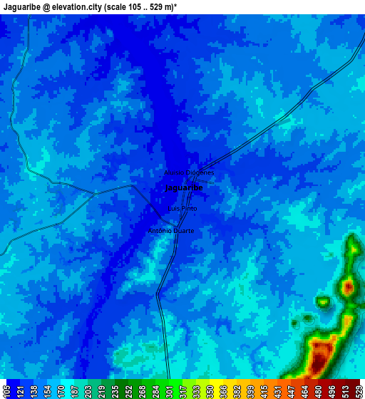

| \ | Map #1 | Map #2 | Topo.Map |
| Scale [m] | 112..190 m | 105..529 m | × |
| Scale [ft] | 367..623 ft | 344..1736 ft | × |
| Average | 137.5 m = 451 ft | 152.2 m = 499 ft | × |
| Width | 9.72 km = 6 mi | 19.44 km = 12.1 mi | 311 km = 193.2 mi |
| Height | 9.72 km = 6 mi | 19.44 km = 12.1 mi | 311.1 km = 193.3 mi |
| ↑Max Latitude | -5.846845° | -5.803127° | -4.49011° |
| Latitude at center | -5.89056° | -5.89056° | -5.89056° |
| ↓Min Latitude | -5.934272° | -5.97798° | -7.28749° |
| ← Min Longitude | -38.665885° | -38.709831° | -40.02819° |
| Longitude center | -38.62194° | -38.62194° | -38.62194° |
| →Max Longitude | -38.577995° | -38.534049° | -37.21569° |
Nearby cities:
Cities around Jaguaribe sort by population:
• Iguatu elevation 222 m
91.2 km,  235°
235°
• Morada Nova 54 m
91.4 km,  17°
17°
• Icó 156 m
62.7 km,  205°
205°
• Senador Pompeu 181 m
89.5 km,  292°
292°
• Orós 193 m
50.9 km,  219°
219°
• Cedro 252 m
93.3 km, 211°
• Alexandria 314 m
88.6 km,  130°
130°
• Umarizal 174 m
90 km,  97°
97°
• Serra Branca 327 m
81.5 km,  151°
151°
• Uiraúna 298 m
73.6 km,  161°
161°
• Triunfo 340 m
75.2 km,  178°
178°
• Severiano Melo 150 m
74.5 km,  80°
80°
Multilingual:
 En español:
Jaguaribe elevación 127 m.
 En France:
Jaguaribe élévation 127 m.
 Auf Deutsch:
Jaguaribe höhe über dem Meeresspiegel ist 127 m.

Sources and notes:
- [note 1] Map square and city borders are not equal. Map elevation data is calculated only from area inside that square.
- [src 1] Elevation data from geonames database provided with same terms of usage.
- [src 2] The elevation map of Jaguaribe is generated using elevation data from NASA's 3 arcsec (90m) resolution SRTM data.
- [src 3] Base (background) map © OpenStreetMap contributors tiles are generated by Geofabrik and OpenTopoMap.
Copyright & License:
This Jaguaribe Elevation Map is licensed under CC BY-SA. You may reuse any part from this page, if you give a proper credit by linking to this URL:
 More info on terms of use page.