Serra Branca elevation
Serra Branca (Paraíba, Vieirópolis), Brazil elevation is 327 meters and Serra Branca elevation in feet is 1073 ft above sea level [src 1]. Serra Branca is a populated place (feature code) with elevation that is 55 meters (180 ft) smaller than average city elevation in Brazil.
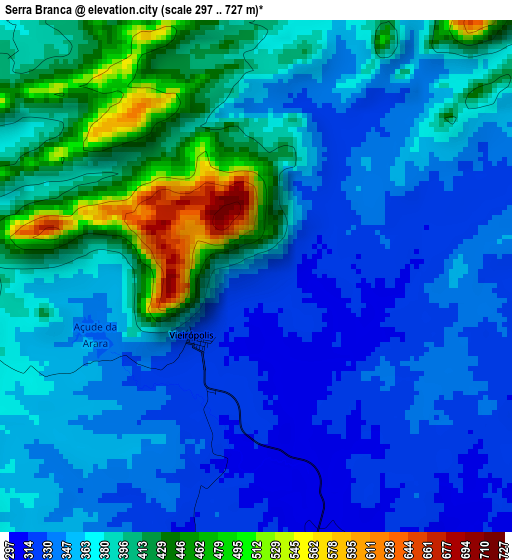
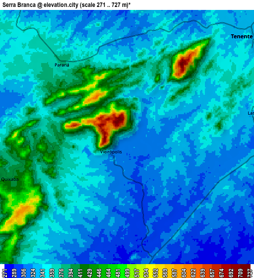
Below is the Elevation map of Serra Branca, which displays elevation range with different colors. Scale of the first map is from 297 to 727 m (974 to 2385 ft) with average elevation of 373.8 meters (=1226 ft) [note 1]
These maps also provides idea of topography and contour of this city, they are displayed at different zoom levels. More info about maps, scale and edge coordinates you can find below images.
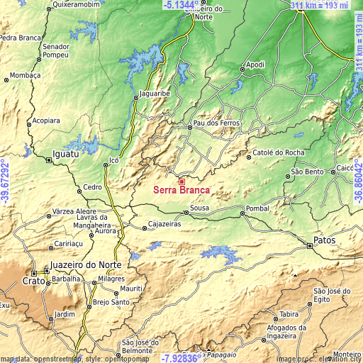
| \ | Map #1 | Map #2 | Topo.Map |
| Scale [m] | 297..727 m | 271..727 m | × |
| Scale [ft] | 974..2385 ft | 889..2385 ft | × |
| Average | 373.8 m = 1226 ft | 356.2 m = 1169 ft | × |
| Width | 9.71 km = 6 mi | 19.42 km = 12.1 mi | 310.7 km = 193.1 mi |
| Height | 9.71 km = 6 mi | 19.42 km = 12.1 mi | 310.7 km = 193.1 mi |
| ↑Max Latitude | -6.489668° | -6.446003° | -5.1344° |
| Latitude at center | -6.53333° | -6.53333° | -6.53333° |
| ↓Min Latitude | -6.576988° | -6.620642° | -7.92836° |
| ← Min Longitude | -38.310615° | -38.354561° | -39.67292° |
| Longitude center | -38.26667° | -38.26667° | -38.26667° |
| →Max Longitude | -38.222725° | -38.178779° | -36.86042° |
Nearby cities:
Cities around Serra Branca sort by population:
• Sousa elevation 229 m
25.5 km,  170°
170°
• Cajazeiras 305 m
50.9 km,  218°
218°
• Icó 156 m
67.4 km,  282°
282°
• São Bento 476 m
63.5 km,  64°
64°
• Pombal 185 m
57.7 km,  117°
117°
• Catolé do Rocha 303 m
61.2 km,  69°
69°
• Coremas 218 m
64.2 km,  146°
146°
• Barro 290 m
69.3 km,  252°
252°
• Alexandria 314 m
30.8 km, 64°
• Juàzeirinho 222 m
39.6 km,  142°
142°
• Uiraúna 298 m
16.2 km, 275°
• Triunfo 340 m
37 km,  264°
264°
Multilingual:
 En español:
Serra Branca elevación 327 m.
 En France:
Serra Branca élévation 327 m.
 Auf Deutsch:
Serra Branca höhe über dem Meeresspiegel ist 327 m.

Sources and notes:
- [note 1] Map square and city borders are not equal. Map elevation data is calculated only from area inside that square.
- [src 1] Elevation data from geonames database provided with same terms of usage.
- [src 2] The elevation map of Serra Branca is generated using elevation data from NASA's 3 arcsec (90m) resolution SRTM data.
- [src 3] Base (background) map © OpenStreetMap contributors tiles are generated by Geofabrik and OpenTopoMap.
Copyright & License:
This Serra Branca Elevation Map is licensed under CC BY-SA. You may reuse any part from this page, if you give a proper credit by linking to this URL:
 More info on terms of use page.