Guanay elevation
Guanay (La Paz, Provincia Larecaja), Bolivia elevation is 477 meters and Guanay elevation in feet is 1565 ft above sea level [src 1]. Guanay is a seat of a third-order administrative division (feature code) with elevation that is 1399 meters (4590 ft) smaller than average city elevation in Bolivia.
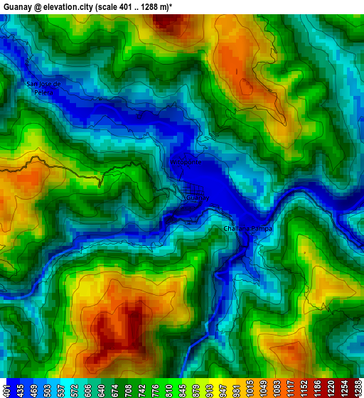
Below is the Elevation map of Guanay, which displays elevation range with different colors. Scale of the first map is from 401 to 1288 m (1316 to 4226 ft) with average elevation of 719.9 meters (=2362 ft) [note 1]
These maps also provides idea of topography and contour of this city, they are displayed at different zoom levels. More info about maps, scale and edge coordinates you can find below images.
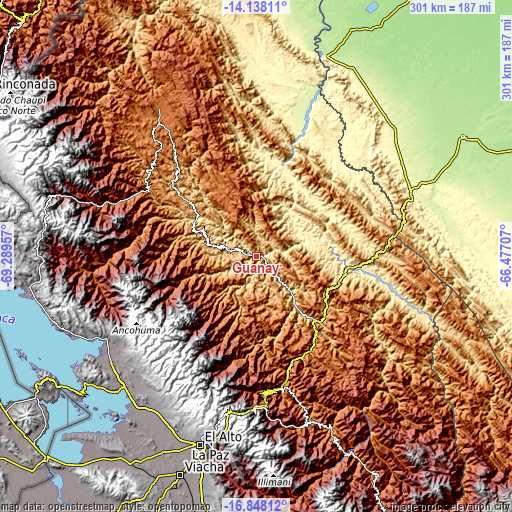
| \ | Map #1 | Topo.Map |
| Scale [m] | 401..1288 m | × |
| Scale [ft] | 1316..4226 ft | × |
| Average | 719.9 m = 2362 ft | × |
| Width | 9.42 km = 5.9 mi | 301.3 km = 187.2 mi |
| Height | 9.42 km = 5.9 mi | 301.3 km = 187.2 mi |
| ↑Max Latitude | -15.455208° | -14.13811° |
| Latitude at center | -15.49756° | -15.49756° |
| ↓Min Latitude | -15.539903° | -16.84812° |
| ← Min Longitude | -67.927265° | -69.28957° |
| Longitude center | -67.88332° | -67.88332° |
| →Max Longitude | -67.839375° | -66.47707° |
Nearby cities:
Cities around Guanay sort by population:
• La Paz elevation 3782 m
115 km,  194°
194°
• Rurrenabaque 210 m
123.5 km,  18°
18°
• Achacachi 3838 m
105.4 km,  234°
234°
• Huatajata 3943 m
115.9 km, 227°
• Chulumani 1871 m
108.1 km,  159°
159°
• Batallas 3849 m
113.1 km,  217°
217°
• Mapiri 806 m
41 km,  312°
312°
• Coroico 1575 m
79.1 km,  168°
168°
• Amarete 3842 m
121.6 km,  283°
283°
• Sorata 2697 m
87.6 km,  249°
249°
• Coripata 1688 m
94.2 km, 161°
• Huarina 3840 m
112 km, 225°
Multilingual:
 En español:
Guanay elevación 477 m.
 En France:
Guanay élévation 477 m.


Sources and notes:
- [note 1] Map square and city borders are not equal. Map elevation data is calculated only from area inside that square.
- [src 1] Elevation data from geonames database provided with same terms of usage.
- [src 2] The elevation map of Guanay is generated using elevation data from NASA's 3 arcsec (90m) resolution SRTM data.
- [src 3] Base (background) map © OpenStreetMap contributors tiles are generated by Geofabrik and OpenTopoMap.
Copyright & License:
This Guanay Elevation Map is licensed under CC BY-SA. You may reuse any part from this page, if you give a proper credit by linking to this URL:
 More info on terms of use page.