Sorata elevation
Sorata (La Paz), Bolivia elevation is 2697 meters and Sorata elevation in feet is 8848 ft above sea level [src 1]. Sorata is a populated place (feature code) with elevation that is 821 meters (2694 ft) bigger than average city elevation in Bolivia.
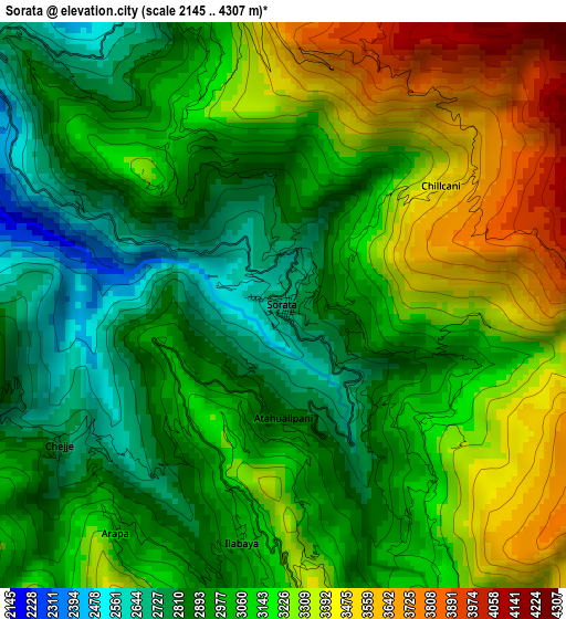
Below is the Elevation map of Sorata, which displays elevation range with different colors. Scale of the first map is from 2145 to 4307 m (7037 to 14131 ft) with average elevation of 3095.3 meters (=10155 ft) [note 1]
These maps also provides idea of topography and contour of this city, they are displayed at different zoom levels. More info about maps, scale and edge coordinates you can find below images.
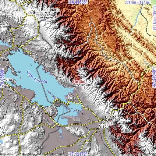
| \ | Map #1 | Topo.Map |
| Scale [m] | 2145..4307 m | × |
| Scale [ft] | 7037..14131 ft | × |
| Average | 3095.3 m = 10155 ft | × |
| Width | 9.4 km = 5.8 mi | 300.9 km = 187 mi |
| Height | 9.4 km = 5.8 mi | 300.9 km = 187 mi |
| ↑Max Latitude | -15.730755° | -14.41535° |
| Latitude at center | -15.77305° | -15.77305° |
| ↓Min Latitude | -15.815336° | -17.12172° |
| ← Min Longitude | -68.693675° | -70.05598° |
| Longitude center | -68.64973° | -68.64973° |
| →Max Longitude | -68.605785° | -67.24348° |
Nearby cities:
Cities around Sorata sort by population:
• La Paz elevation 3782 m
96.9 km,  146°
146°
• Achacachi 3838 m
31 km,  186°
186°
• San Pedro 4013 m
55.9 km,  202°
202°
• Huatajata 3943 m
47.6 km,  184°
184°
• San Pablo 3931 m
53.1 km, 201°
• Tiahuanaco 3860 m
86.7 km, 182°
• Mapiri 806 m
77.9 km,  41°
41°
• Batallas 3849 m
59.9 km,  168°
168°
• Yumani 3972 m
60.8 km,  241°
241°
• Amarete 3842 m
69.6 km,  328°
328°
• Huarina 3840 m
47.5 km, 177°
• Guanay 477 m
87.6 km,  69°
69°
Multilingual:
 En español:
Sorata elevación 2697 m.
 En France:
Sorata élévation 2697 m.


Sources and notes:
- [note 1] Map square and city borders are not equal. Map elevation data is calculated only from area inside that square.
- [src 1] Elevation data from geonames database provided with same terms of usage.
- [src 2] The elevation map of Sorata is generated using elevation data from NASA's 3 arcsec (90m) resolution SRTM data.
- [src 3] Base (background) map © OpenStreetMap contributors tiles are generated by Geofabrik and OpenTopoMap.
Copyright & License:
This Sorata Elevation Map is licensed under CC BY-SA. You may reuse any part from this page, if you give a proper credit by linking to this URL:
 More info on terms of use page.