La Paz elevation
La Paz, Bolivia elevation is 3782 meters and La Paz elevation in feet is 12408 ft above sea level [src 1]. La Paz is a seat of government of a political entity (feature code) with elevation that is 1906 meters (6253 ft) bigger than average city elevation in Bolivia.
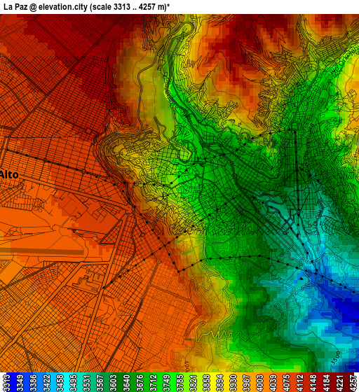
Below is the Elevation map of La Paz, which displays elevation range with different colors. Scale of the first map is from 3313 to 4257 m (10869 to 13967 ft) with average elevation of 3907.2 meters (=12819 ft) [note 1]
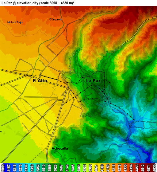
These maps also provides idea of topography and contour of this city, they are displayed at different zoom levels. More info about maps, scale and edge coordinates you can find below images.
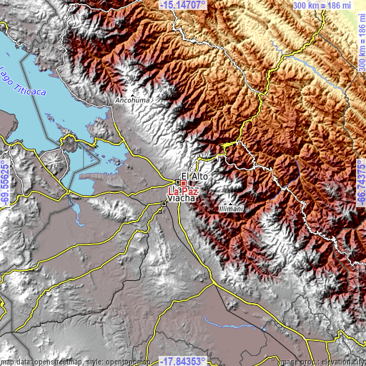
| \ | Map #1 | Map #2 | Topo.Map |
| Scale [m] | 3313..4257 m | 3098..4630 m | × |
| Scale [ft] | 10869..13967 ft | 10164..15190 ft | × |
| Average | 3907.2 m = 12819 ft | 3928.8 m = 12890 ft | × |
| Width | 9.37 km = 5.8 mi | 18.74 km = 11.6 mi | 299.8 km = 186.3 mi |
| Height | 9.37 km = 5.8 mi | 18.74 km = 11.6 mi | 299.8 km = 186.3 mi |
| ↑Max Latitude | -16.45786° | -16.41571° | -15.14707° |
| Latitude at center | -16.5° | -16.5° | -16.5° |
| ↓Min Latitude | -16.542131° | -16.584253° | -17.84353° |
| ← Min Longitude | -68.193945° | -68.237891° | -69.55625° |
| Longitude center | -68.15° | -68.15° | -68.15° |
| →Max Longitude | -68.106055° | -68.062109° | -66.74375° |
Nearby cities:
Cities around La Paz sort by population:
• Patacamaya elevation 3799 m
85.3 km,  163°
163°
• Achacachi 3838 m
75.8 km,  311°
311°
• San Pedro 4013 m
80.3 km,  291°
291°
• Huatajata 3943 m
66 km,  300°
300°
• San Pablo 3931 m
79.4 km, 293°
• Tiahuanaco 3860 m
56.7 km,  264°
264°
• Chulumani 1871 m
67 km,  81°
81°
• Batallas 3849 m
46.5 km, 298°
• Coroico 1575 m
56.3 km,  52°
52°
• Coripata 1688 m
62.7 km,  69°
69°
• Viloco 3761 m
81.2 km,  128°
128°
• Huarina 3840 m
61.4 km, 302°
Multilingual:
 En español:
La Paz elevación 3782 m.
 En France:
La Paz élévation 3782 m.


Sources and notes:
- [note 1] Map square and city borders are not equal. Map elevation data is calculated only from area inside that square.
- [src 1] Elevation data from geonames database provided with same terms of usage.
- [src 2] The elevation map of La Paz is generated using elevation data from NASA's 3 arcsec (90m) resolution SRTM data.
- [src 3] Base (background) map © OpenStreetMap contributors tiles are generated by Geofabrik and OpenTopoMap.
Copyright & License:
This La Paz Elevation Map is licensed under CC BY-SA. You may reuse any part from this page, if you give a proper credit by linking to this URL:
 More info on terms of use page.