Viloco elevation
Viloco (La Paz), Bolivia elevation is 3761 meters and Viloco elevation in feet is 12339 ft above sea level [src 1]. Viloco is a populated place (feature code) with elevation that is 1885 meters (6184 ft) bigger than average city elevation in Bolivia.
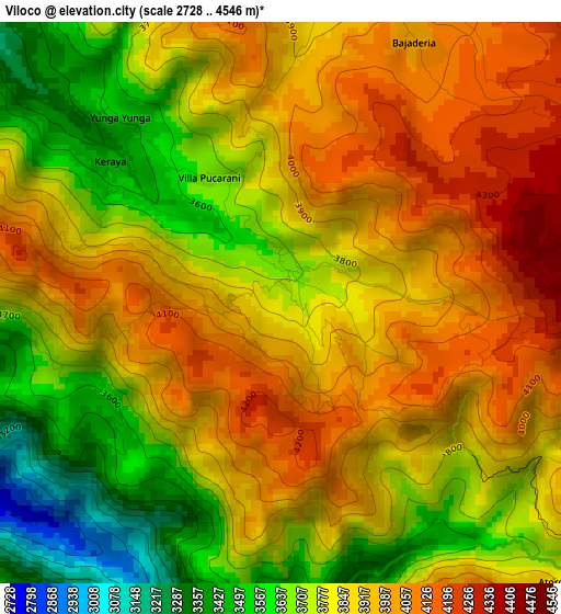
Below is the Elevation map of Viloco, which displays elevation range with different colors. Scale of the first map is from 2728 to 4546 m (8950 to 14915 ft) with average elevation of 3837.6 meters (=12591 ft) [note 1]
These maps also provides idea of topography and contour of this city, they are displayed at different zoom levels. More info about maps, scale and edge coordinates you can find below images.
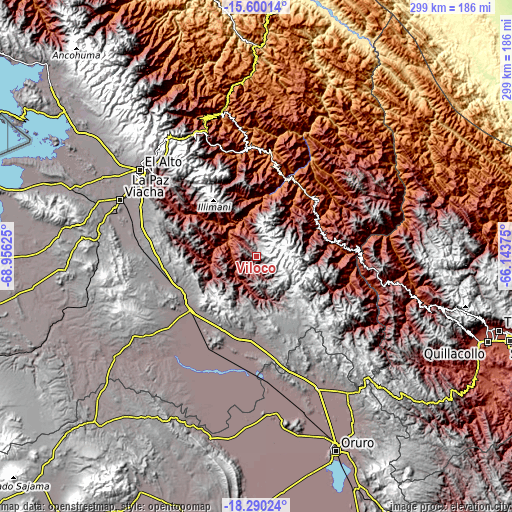
| \ | Map #1 | Topo.Map |
| Scale [m] | 2728..4546 m | × |
| Scale [ft] | 8950..14915 ft | × |
| Average | 3837.6 m = 12591 ft | × |
| Width | 9.35 km = 5.8 mi | 299.1 km = 185.9 mi |
| Height | 9.35 km = 5.8 mi | 299.1 km = 185.9 mi |
| ↑Max Latitude | -16.907959° | -15.60014° |
| Latitude at center | -16.95° | -16.95° |
| ↓Min Latitude | -16.992032° | -18.29024° |
| ← Min Longitude | -67.593945° | -68.95625° |
| Longitude center | -67.55° | -67.55° |
| →Max Longitude | -67.506055° | -66.14375° |
Nearby cities:
Cities around Viloco sort by population:
• La Paz elevation 3782 m
81.2 km,  308°
308°
• Oruro 3936 m
122.5 km,  159°
159°
• Patacamaya 3799 m
50.7 km,  231°
231°
• Colquiri 4276 m
66.4 km,  137°
137°
• Lahuachaca 3806 m
48.6 km,  195°
195°
• Chulumani 1871 m
60.2 km,  2°
2°
• Quime 3063 m
35.6 km,  95°
95°
• Eucaliptus 3734 m
70.5 km,  177°
177°
• Coroico 1575 m
86.2 km,  347°
347°
• Coripata 1688 m
72.5 km,  355°
355°
• Colchani 3411 m
97.5 km,  114°
114°
• Independencia 2638 m
79.2 km, 100°
Multilingual:
 En español:
Viloco elevación 3761 m.
 En France:
Viloco élévation 3761 m.


Sources and notes:
- [note 1] Map square and city borders are not equal. Map elevation data is calculated only from area inside that square.
- [src 1] Elevation data from geonames database provided with same terms of usage.
- [src 2] The elevation map of Viloco is generated using elevation data from NASA's 3 arcsec (90m) resolution SRTM data.
- [src 3] Base (background) map © OpenStreetMap contributors tiles are generated by Geofabrik and OpenTopoMap.
Copyright & License:
This Viloco Elevation Map is licensed under CC BY-SA. You may reuse any part from this page, if you give a proper credit by linking to this URL:
 More info on terms of use page.