Oruro elevation
Oruro, Bolivia elevation is 3936 meters and Oruro elevation in feet is 12913 ft above sea level [src 1]. Oruro is a seat of a first-order administrative division (feature code) with elevation that is 2060 meters (6759 ft) bigger than average city elevation in Bolivia.
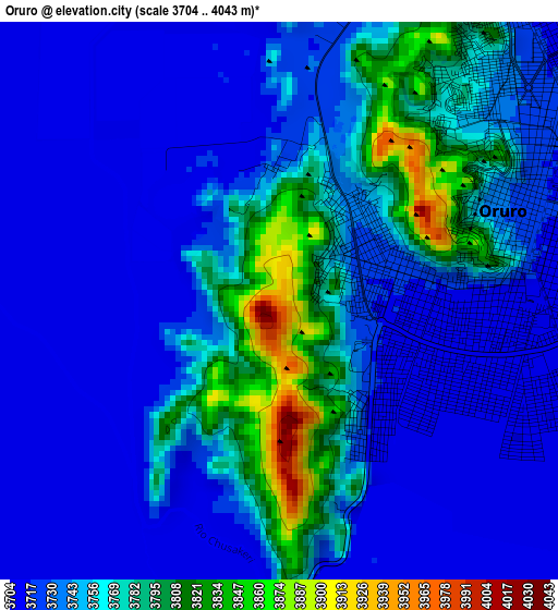
Below is the Elevation map of Oruro, which displays elevation range with different colors. Scale of the first map is from 3704 to 4043 m (12152 to 13264 ft) with average elevation of 3748 meters (=12297 ft) [note 1]
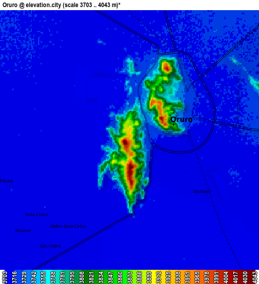
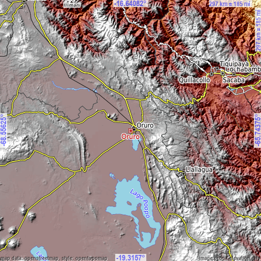
These maps also provides idea of topography and contour of this city, they are displayed at different zoom levels. More info about maps, scale and edge coordinates you can find below images.
| \ | Map #1 | Map #2 | Topo.Map |
| Scale [m] | 3704..4043 m | 3703..4043 m | × |
| Scale [ft] | 12152..13264 ft | 12149..13264 ft | × |
| Average | 3748 m = 12297 ft | 3722.4 m = 12213 ft | × |
| Width | 9.3 km = 5.8 mi | 18.59 km = 11.6 mi | 297.4 km = 184.8 mi |
| Height | 9.3 km = 5.8 mi | 18.59 km = 11.6 mi | 297.4 km = 184.8 mi |
| ↑Max Latitude | -17.941527° | -17.899713° | -16.64082° |
| Latitude at center | -17.98333° | -17.98333° | -17.98333° |
| ↓Min Latitude | -18.025123° | -18.066907° | -19.3157° |
| ← Min Longitude | -67.193945° | -67.237891° | -68.55625° |
| Longitude center | -67.15° | -67.15° | -67.15° |
| →Max Longitude | -67.106055° | -67.062109° | -65.74375° |
Nearby cities:
Cities around Oruro sort by population:
• Llallagua elevation 3897 m
77.3 km,  129°
129°
• Huanuni 3963 m
47.5 km,  135°
135°
• Capinota 2395 m
98.9 km,  72°
72°
• Colquiri 4276 m
66.1 km,  2°
2°
• Lahuachaca 3806 m
88 km,  320°
320°
• Irpa Irpa 2467 m
98.1 km, 72°
• Eucaliptus 3734 m
59 km, 318°
• Machacamarca 3728 m
25.1 km,  147°
147°
• Poopó 3756 m
48.2 km,  156°
156°
• Totoral 3900 m
64 km, 152°
• Colchani 3411 m
87.2 km,  31°
31°
• Andamarca 3751 m
96.2 km,  203°
203°
Multilingual:
 En español:
Oruro elevación 3936 m.
 En France:
Oruro élévation 3936 m.


Sources and notes:
- [note 1] Map square and city borders are not equal. Map elevation data is calculated only from area inside that square.
- [src 1] Elevation data from geonames database provided with same terms of usage.
- [src 2] The elevation map of Oruro is generated using elevation data from NASA's 3 arcsec (90m) resolution SRTM data.
- [src 3] Base (background) map © OpenStreetMap contributors tiles are generated by Geofabrik and OpenTopoMap.
Copyright & License:
This Oruro Elevation Map is licensed under CC BY-SA. You may reuse any part from this page, if you give a proper credit by linking to this URL:
 More info on terms of use page.